Mosque nearby Mushola Miftahul Khair
Indonesia
Mosque nearby Mushola Miftahul Khair
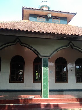
Mushola Miftahul Khair
Jalan Kampung Cikiwul No.105, Cikiwul Indonesia
contacts phone
:
+62
Latitude:
-6.3397598
, Longitude:
106.9827041
read more
nearest Mosque
31 m
Mushola Miftahul Khoir
Jalan Kampung Cikiwul No.71, Cikiwul
Mosque
read more
285 m
Masjid Al Fudhola
Jalan Gang Majlis Ta'lim No.46, Cikiwul
Mosque
read more
285 m
Masjid Al Fudhola
Cikiwul, RT. 003 RW. 006, Bantargebang, Cikiwul
Mosque
read more
327 m
Masjid ARMED
20,, Jalan Kampung Cikiwul No.19, Cikiwul
Mosque
read more
347 m
Masjid Al Wasilah
Jalan Cikiwul No.70, Cikiwul
Mosque
read more
350 m
Masjid Al Magfiroh
Jalan Cikiwul No.70, Cikiwul
Mosque
read more
517 m
Mushola Miftahul Huda
Jalan Cikiwul No.17, Cikiwul
Mosque
read more
540 m
Masjid Jami' Al Hamidiyah
Jalan Raya Narogong KM 11 No.13, Cikiwul
Mosque
read more
549 m
Masjid Al Almidiyah
Jalan Raya Narogong Cikiwul Bantar Gebang Bekasi, Cikiwul
Mosque
read more
573 m
Mushola Al Jannah
Jl. Kemuning 1, Blok g Blok g No.10, Cikiwul
Mosque
read more
626 m
MUSHOLLA AL-AMANAH
Gang Sa'on, Cikiwul
Mosque
read more
754 m
Masjid Baiturahim
Jl. Raya TPA Blok, Rama Blok Rama No.93, Cikiwul
Mosque
read more
805 m
Mushola Al Kamilah
Cikiwul
Mosque
read more
836 m
Jami Masjid Nurul Hikmah
Jalan Rawa Tengah, Cikiwul
Mosque
read more
859 m
Masjid Jami Ar-Ramdhan
Jl. Bali Rotan RT.02 RW. 05, 17152, Cikiwul
Mosque
read more
894 m
Masjid Arrayyan
Ciangsana
Mosque
read more
945 m
Mushola Al-barkah
Unnamed Road, Cikiwul
Mosque
read more
1.039 km
Ad-dyar
Jalan Pangkalan 2, Cikiwul
Mosque
read more
1.078 km
Musholla Nurul Istiqomah
Jalan Kampung Ciketing Udik No.56, Ciketing Udik
Mosque
read more
1.086 km
Masjid Pangkalan 2
Jalan Pangkalan 2 No.315, Cikiwul
Mosque
read more
1.095 km
Masjid Nurul Amal
Jalan Pangkalan 2, Cikiwul
Mosque
read more
1.166 km
masjid al-jihad
Jalan Pangkalan V No.7500, Ciketing Udik
Mosque
read more
1.238 km
Mushola Daarul Mu'miniin
Bojong Kulur
Mosque
read more
2.002 km
Musholla Arrohman
Jalan Raya Ciangsana No.88, Ciangsana
Mosque
read more
2.497 km
Masjid Bojong Kulur
Jalan Raya Bojong Kulur No.68, Bojong Kulur
Mosque
read more
📑
all categories
Accounting
Administrative area level 1
Administrative area level 2
Airport
Amusement park
Aquarium
Art gallery
Atm
Bakery
Bank
Bar
Beauty salon
Bicycle store
Book store
Bowling alley
Bus station
Cafe
Campground
Car dealer
Car rental
Car repair
Car wash
Casino
Cemetery
Church
City hall
Clothing store
Colloquial area
Convenience store
Courthouse
Dentist
Department store
Doctor
Electrician
Electronics store
Embassy
Finance
Fire station
Florist
Food
Funeral home
Furniture store
Gas station
General contractor
Grocery or supermarket
Gym
Hair care
Hardware store
Health
Hindu Temple
Home goods store
Hospital
Insurance agency
Intersection
Jewelry store
Laundry
Lawyer
Library
Liquor store
Local government office
Locality
Locksmith
Lodging
Meal delivery
Meal takeaway
Mosque
Movie rental
Movie theater
Moving company
Museum
Natural feature
Neighborhood
Night club
Painter
Park
Parking
Pet store
Pharmacy
Physiotherapist
Place of worship
Plumber
Point of interest
Police
Political
Post office
Premise
Real estate agency
Restaurant
Roofing contractor
Route
Rv park, camping
School
Shoe store
Shopping mall
Spa
Stadium
Storage
Store
Subpremise
Supermarket
Synagogue
Taxi stand
Train station
Transit station
Travel agency
University
Veterinary care
Zoo
administrative area level 3
administrative area level 4
administrative area level 5
sublocality level 1
↑