Lodging nearby Villa H. Nana
Indonesia
Lodging nearby Villa H. Nana
Villa H. Nana
Bojong Murni, Ciawi, Bogor, West Java 16720, Indonesia
contacts phone
:
+62
Latitude:
-6.700511
, Longitude:
106.8967895
larger map & directions
read more
nearest Lodging
285 m
Villa Keluarga DIVA
Jalan Karakal No.10, Bojong Murni
Lodging
read more
480 m
Ajengan Suja Bojong
Jalan Karakal
Lodging
read more
816 m
Nursery Area Camp Hulu Cai
Cibedug
Lodging
read more
820 m
Jeep Station Indonesia
Jalan Raya Pasir Muncang No.218, Sukamanah
Lodging
read more
832 m
Villa Rafain
Jalan Raya Pasir Muncang No.155, Sukamanah
Lodging
read more
839 m
Saung Riyadhoh Guru SaBaTin
Cijeruk, Sukamanah
Lodging
read more
1.052 km
Camp Hulu Cai
Jl. Veteran III Cibedug, Ciawi, Cibedug
Lodging
read more
1.104 km
Wisma CP Arca
Jalan Raya Pasir Muncang, Sukaresmi
Lodging
read more
1.139 km
JEEP STATION INDONESIA
Sukaresmi
Lodging
read more
1.141 km
Ponpes Al Idrisiyyah
Sukamanah
Lodging
read more
1.217 km
Villa Palapa Ganda
Jalan Karakal No.57, Jambu Luwuk
Lodging
read more
1.504 km
Cherokee Tent JSI
Sukagalih
Lodging
read more
1.528 km
Villa Hijau Hasanah
Unnamed Road, Sukamanah
Lodging
read more
1.599 km
Ci Anjawar
cianjawar, Sukamanah
Lodging
read more
1.775 km
Hardi VILLA 88
Cibedug
Lodging
read more
1.836 km
Vila Pelangi
Jalan Tapos Lbc No.23, Citapen
Lodging
read more
1.856 km
Villa 88
Jl. Pasir Kalong No. 37, Megamendung, Sukagalih
Lodging
read more
1.881 km
SEDAP ALAMI
Jalan Cikopo Selatan, Sukagalih
Lodging
read more
1.98 km
Almor Stable
Sukamanah
Lodging
read more
2.086 km
Vila Bumi Elok Resort
Sukagalih
Lodging
read more
2.315 km
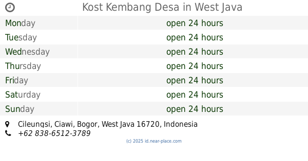
Kost Kembang Desa
Cileungsi
Lodging
read more
2.323 km
Bungalow Yongky
Jalan Tapos Lbc, Cileungsi
Lodging
read more
2.358 km
Villa Faijo
Jalan Waru Doyong No.41, Kuta
Lodging
read more
2.63 km
Villa Gunung Alam
Cileungsi
Lodging
read more
2.63 km
Villa Lembah Alam
Cileungsi
Lodging
read more
📑
all categories
Accounting
Administrative area level 1
Administrative area level 2
Airport
Amusement park
Aquarium
Art gallery
Atm
Bakery
Bank
Bar
Beauty salon
Bicycle store
Book store
Bowling alley
Bus station
Cafe
Campground
Car dealer
Car rental
Car repair
Car wash
Casino
Cemetery
Church
City hall
Clothing store
Colloquial area
Convenience store
Courthouse
Dentist
Department store
Doctor
Electrician
Electronics store
Embassy
Finance
Fire station
Florist
Food
Funeral home
Furniture store
Gas station
General contractor
Grocery or supermarket
Gym
Hair care
Hardware store
Health
Hindu Temple
Home goods store
Hospital
Insurance agency
Intersection
Jewelry store
Laundry
Lawyer
Library
Liquor store
Local government office
Locality
Locksmith
Lodging
Meal delivery
Meal takeaway
Mosque
Movie rental
Movie theater
Moving company
Museum
Natural feature
Neighborhood
Night club
Painter
Park
Parking
Pet store
Pharmacy
Physiotherapist
Place of worship
Plumber
Point of interest
Police
Political
Post office
Premise
Real estate agency
Restaurant
Roofing contractor
Route
Rv park, camping
School
Shoe store
Shopping mall
Spa
Stadium
Storage
Store
Subpremise
Supermarket
Synagogue
Taxi stand
Train station
Transit station
Travel agency
University
Veterinary care
Zoo
administrative area level 3
administrative area level 4
administrative area level 5
sublocality level 1
↑