Cafe nearby SNUFF cafe
Indonesia
Cafe nearby SNUFF cafe
SNUFF cafe
Jalan Nasional III, Sukamanah Indonesia
contacts phone
:
+62
Latitude:
-6.9098247
, Longitude:
106.8939992
read more
nearest Cafe
208 m
Cappucino Cincau Idano
Jalan Raya Cisaat, Sukamanah
Cafe
read more
214 m
Warung S O C B
Sukamanah
Cafe
read more
243 m
Coffee Mandiri
Gelanggang samping damkar, Jalan Cikiray Kidul, Sukamanah
Cafe
read more
292 m
Kedai Masbro
Cisaat
Cafe
read more
294 m
Hansip Gor Squad
Jalan Pasar Baru, Sukamanah
Cafe
read more
313 m
ZILDAN waroeng roti & kopi
Cisaat
Cafe
read more
347 m
Rajufood
Jalan Sukamanah II, Sukamanah
Cafe
read more
364 m
Kedai Coffee Pasteu 02
Komplek Alun-Alun, Samping Baznas
Cafe
read more
369 m
Coffee Pasteu 02
Cisaat
Cafe
read more
369 m
Coffee Pasteu 02
Cafe
read more
382 m
Chandoo Cheese Tea
Jalan Raya Rambay No.3A, Sukamanah
Cafe
read more
382 m
Warung Abee
Jalan Raya Sukaraja - Sukabumi, Sukamanah
Cafe
read more
409 m
Warkop Gen
Cisaat
Cafe
read more
491 m
Warung Elang
Jalan Cikiray-Cijambu, Sukamanah
Cafe
read more
534 m
Roti Bakar CS
Jalan Raya Cisaat, Sukamanah
Cafe
read more
540 m
Nutrition Club NCD Ceria
Jl. Raya Rambay no.49 Depan Koramil, Sukamantri
Cafe
read more
568 m
Waroeng D'es krim
Jalan Raya Veteran, Cisaat
Cafe
read more
571 m
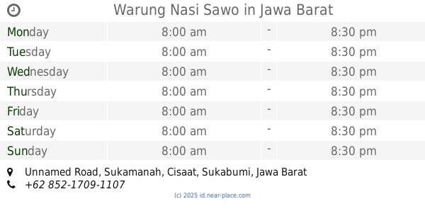
Warung Nasi Sawo
Unnamed Road, Sukamanah
Cafe
read more
697 m
Audya Alamsyah
Sukamanah, Cisaat, Sukamanah
Cafe
read more
726 m
Sate Abg Sobur
Jalan Pajajaran I No.36, Sukamantri
Cafe
read more
744 m
Kedai Bananaboy
Jalan Raya Veteran, Cisaat
Cafe
read more
810 m
Kedai Alfath/tutut Surudut Ummi
Jalan Raya Veteran, Cisaat
Cafe
read more
810 m
YAN'S PIZZA & CAKE
Jalan Citengkor - Mangkalaya, Cisaat
Cafe
read more
853 m
Warnet JAWA-RA
Nagrak
Cafe
read more
1.278 km
basecamp grabbike BGS pusat
Cisaat
Cafe
read more
📑
all categories
Accounting
Administrative area level 1
Administrative area level 2
Airport
Amusement park
Aquarium
Art gallery
Atm
Bakery
Bank
Bar
Beauty salon
Bicycle store
Book store
Bowling alley
Bus station
Cafe
Campground
Car dealer
Car rental
Car repair
Car wash
Casino
Cemetery
Church
City hall
Clothing store
Colloquial area
Convenience store
Courthouse
Dentist
Department store
Doctor
Electrician
Electronics store
Embassy
Finance
Fire station
Florist
Food
Funeral home
Furniture store
Gas station
General contractor
Grocery or supermarket
Gym
Hair care
Hardware store
Health
Hindu Temple
Home goods store
Hospital
Insurance agency
Intersection
Jewelry store
Laundry
Lawyer
Library
Liquor store
Local government office
Locality
Locksmith
Lodging
Meal delivery
Meal takeaway
Mosque
Movie rental
Movie theater
Moving company
Museum
Natural feature
Neighborhood
Night club
Painter
Park
Parking
Pet store
Pharmacy
Physiotherapist
Place of worship
Plumber
Point of interest
Police
Political
Post office
Premise
Real estate agency
Restaurant
Roofing contractor
Route
Rv park, camping
School
Shoe store
Shopping mall
Spa
Stadium
Storage
Store
Subpremise
Supermarket
Synagogue
Taxi stand
Train station
Transit station
Travel agency
University
Veterinary care
Zoo
administrative area level 3
administrative area level 4
administrative area level 5
sublocality level 1
↑