Cafe nearby Qori Anisah Kafe
Indonesia
Cafe nearby Qori Anisah Kafe
Qori Anisah Kafe
West Kosambi Indonesia
contacts phone
:
+62
Latitude:
-6.0743986
, Longitude:
106.6937936
read more
nearest Cafe
6 m
Rumah Makan Muhiya Yanti
West Kosambi
Cafe
read more
108 m
Hamchoikon Cafe
West Kosambi
Cafe
read more
826 m
Giss Gemilang Studio Musik
Jalan Kampung Rawa Lumpang, Salembaran Jati
Cafe
read more
942 m
TDRT KOSAMBI
Jalan Raya Kosambi Timur No.19, Kosambi Timur
Cafe
read more
1.004 km
Warung Sdn Cengklong 3
SDN CENGKLONG 3, Cengklong
Cafe
read more
1.06 km
Liong Cafe
Salembaran Jati
Cafe
read more
1.191 km
Warung Bacang Cang Rani
Jalan Nurul Falah No.18, Kosambi Timur
Cafe
read more
1.246 km
Patpatlin Cafe
Unnamed Road, Salembaran Jati
Cafe
read more
1.284 km
Cafe Noah 4
no., Jalan Raya Salembaran No.7, Kampung Melayu Timur
Cafe
read more
1.289 km
Warung Xibox
Unnamed Road, Cengklong
Cafe
read more
1.362 km
Alim Sosis
Cengklong
Cafe
read more
1.453 km
Boemen Motor Custom BMC
Jatimulya
Cafe
read more
1.574 km
Minang Cafe
Jalan Perancis Blok Bd No.1, Dadap
Cafe
read more
1.73 km
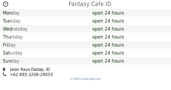
Fantasy Cafe
Jalan Raya Dadap
Cafe
read more
1.864 km
Villa Taman Permai Airport
Jalan Perancis Blok Bc No.19, Dadap
Cafe
read more
1.872 km
Warung Bp.Nasir
Jalan Villa Taman Bandara 2 Blok O-1 No.33, Dadap
Cafe
read more
1.888 km
GDC Cafe
Blok N-2, Jalan Villa Taman Bandara 2 Blok N-2 No.46, Dadap
Cafe
read more
1.894 km
Kggb Garuda Dadap
Jalan Villa Taman Bandara 2, Dadap
Cafe
read more
1.902 km
KAFE HOLIDAY
Blok N-2, Jalan Villa Taman Bandara 2 Blok N-2 No.3, Dadap
Cafe
read more
1.917 km
Big Big Thai Tea 2
Garuda, Dadap
Cafe
read more
1.923 km
warung kang nana
Dadap
Cafe
read more
1.954 km
Jojo Thai Tea
Blok O-5, Jalan Villa Taman Bandara 2 Blok O-5 No.20, Dadap
Cafe
read more
1.999 km
Sate Bakut Babi Tan Dean
Jalan Perancis Blok B5 No.22, Kosambi Timur
Cafe
read more
2.252 km
Waroeng Oos
Jalan Perancis, Dadap
Cafe
read more
2.266 km
Warung Mamih Sulyang
Unnamed Road, Dadap
Cafe
read more
📑
all categories
Accounting
Administrative area level 1
Administrative area level 2
Airport
Amusement park
Aquarium
Art gallery
Atm
Bakery
Bank
Bar
Beauty salon
Bicycle store
Book store
Bowling alley
Bus station
Cafe
Campground
Car dealer
Car rental
Car repair
Car wash
Casino
Cemetery
Church
City hall
Clothing store
Colloquial area
Convenience store
Courthouse
Dentist
Department store
Doctor
Electrician
Electronics store
Embassy
Finance
Fire station
Florist
Food
Funeral home
Furniture store
Gas station
General contractor
Grocery or supermarket
Gym
Hair care
Hardware store
Health
Hindu Temple
Home goods store
Hospital
Insurance agency
Intersection
Jewelry store
Laundry
Lawyer
Library
Liquor store
Local government office
Locality
Locksmith
Lodging
Meal delivery
Meal takeaway
Mosque
Movie rental
Movie theater
Moving company
Museum
Natural feature
Neighborhood
Night club
Painter
Park
Parking
Pet store
Pharmacy
Physiotherapist
Place of worship
Plumber
Point of interest
Police
Political
Post office
Premise
Real estate agency
Restaurant
Roofing contractor
Route
Rv park, camping
School
Shoe store
Shopping mall
Spa
Stadium
Storage
Store
Subpremise
Supermarket
Synagogue
Taxi stand
Train station
Transit station
Travel agency
University
Veterinary care
Zoo
administrative area level 3
administrative area level 4
administrative area level 5
sublocality level 1
↑