Mosque nearby Mesjid Jamie Al Ikhlas
Indonesia
Mosque nearby Mesjid Jamie Al Ikhlas
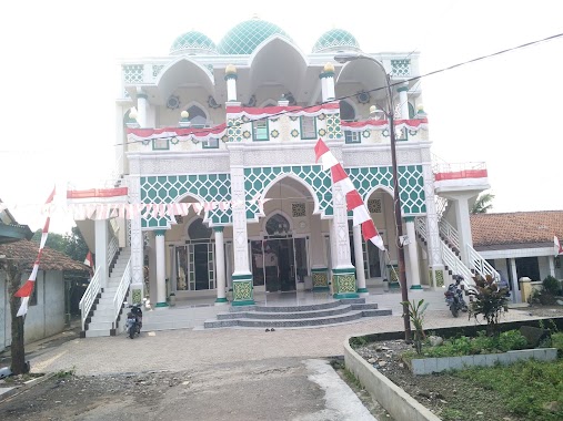
Mesjid Jamie Al Ikhlas
Kampung Kaleng, Jalan Kampung Dukuh, Pasir Mukti Indonesia
contacts phone
:
+62
Latitude:
-6.5089769
, Longitude:
106.8926425
read more
nearest Mosque
517 m
Masjid Al Muslih
Jalan Raya Tajur Pasir Mukti No.512, Pasir Mukti
Mosque
read more
633 m
Musholla As Saidiyyah
Jalan Raya Tajur Pasir Mukti, Pasir Mukti
Mosque
read more
822 m
MASJID JAMI HAMIDUL ANWAR
Unnamed Road, Pasir Mukti
Mosque
read more
866 m
Mesjid Albarokah
Pasir Mukti
Mosque
read more
1.042 km
As Shidiq, Bumi Rancamanyar
Jalan Sebayak Ngerajai Blok B2 No.9-10, Citeureup, Sukahati
Mosque
read more
1.402 km
Masjid Al Muqqarabin
Jalan Kampung Tonggoh, Gunung Sari
Mosque
read more
1.408 km
Masjid Alhidayah
No., Jalan Raya Tajur No.8, Tajur
Mosque
read more
1.448 km
Masjid At - Taqwa
Tarikolot
Mosque
read more
1.462 km
Masjid At Torihiyah
JL. Tajur, RT. 04 RW. 03, Bogor Timur, Tarikolot
Mosque
read more
1.488 km
Masjid Jami Nurul Huda
Kp. Sangkali, Desa, Jalan Pangeran Samiaji Kampung Nagrog, Sukahati
Mosque
read more
1.488 km
Masjid Jami' Nurul Huda
Jalan Kampung Sangkali, Sukahati
Mosque
read more
1.653 km
Mushola Al-hidayah Tarikolot RT.02/07
Tarikolot
Mosque
read more
1.689 km
Masjid Al-Mustofa'iyah
Jalan Sabililah No.119, Citeureup
Mosque
read more
1.711 km
Masjid Al Hurriyah
Tarikolot
Mosque
read more
1.821 km
Masjid Al-ikhlas Tarikolot
Jalan Industri No.27, Tarikolot
Mosque
read more
1.886 km
Masjid Balai Desa
Jalan Industri No.65, Tarikolot
Mosque
read more
1.902 km
Nurul Islam Mosque
odeng desa. leuwikaret
Mosque
read more
2.001 km
Masjid Al-Muhsanat
Perum Pondok Citeureup Indah, Jalan Elang, Sukahati, Citeureup, Sukahati
Mosque
read more
2.006 km
Masjid Darussalam
Jalan Industri Tengah, RT. 03 / RW. 03, Gunung Sari, Citeureup, Gunung Sari
Mosque
read more
2.026 km
Mushalla Asy Syababiyah
JL. Kyai Haji Natsir, RT. 01 RW. 03, Citeureup, Hambalang
Mosque
read more
2.119 km
Masjid Ponpes Mamba'ul Hikam
Gg. Dalam Maksan, Karang Asem Timur
Mosque
read more
2.327 km
Masjid Al Ishlah
Gang Mesjid Karang Asem Timur, Karang Asem Timur
Mosque
read more
2.422 km
Musholah Al-hidayah
Jalan Pahlawan No.100, Karang Asem Barat
Mosque
read more
2.424 km
Masjid Jami' Yaa Qoyyuumm Kawasan IPSC
Jalan Anyar, Sukahati
Mosque
read more
2.745 km
Mesjid AL-HUDA
Jalan Kenanga, Karang Asem Barat
Mosque
read more
📑
all categories
Accounting
Administrative area level 1
Administrative area level 2
Airport
Amusement park
Aquarium
Art gallery
Atm
Bakery
Bank
Bar
Beauty salon
Bicycle store
Book store
Bowling alley
Bus station
Cafe
Campground
Car dealer
Car rental
Car repair
Car wash
Casino
Cemetery
Church
City hall
Clothing store
Colloquial area
Convenience store
Courthouse
Dentist
Department store
Doctor
Electrician
Electronics store
Embassy
Finance
Fire station
Florist
Food
Funeral home
Furniture store
Gas station
General contractor
Grocery or supermarket
Gym
Hair care
Hardware store
Health
Hindu Temple
Home goods store
Hospital
Insurance agency
Intersection
Jewelry store
Laundry
Lawyer
Library
Liquor store
Local government office
Locality
Locksmith
Lodging
Meal delivery
Meal takeaway
Mosque
Movie rental
Movie theater
Moving company
Museum
Natural feature
Neighborhood
Night club
Painter
Park
Parking
Pet store
Pharmacy
Physiotherapist
Place of worship
Plumber
Point of interest
Police
Political
Post office
Premise
Real estate agency
Restaurant
Roofing contractor
Route
Rv park, camping
School
Shoe store
Shopping mall
Spa
Stadium
Storage
Store
Subpremise
Supermarket
Synagogue
Taxi stand
Train station
Transit station
Travel agency
University
Veterinary care
Zoo
administrative area level 3
administrative area level 4
administrative area level 5
sublocality level 1
↑