Cafe nearby Exitgluck Cafe, Cinere
Indonesia
Cafe nearby Exitgluck Cafe, Cinere
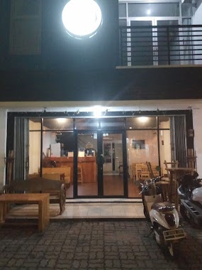
Exitgluck Cafe, Cinere
36, Jalan Raya Meruyung, 16514, Kota Depok, Jawa Barat, ID Indonesia
contacts phone
:
+62
Latitude:
-6.3511014
, Longitude:
106.7760644
larger map & directions
read more
nearest Cafe
248 m
Warung Pintar Bojongsari 2
Jalan Limo Raya No.44-18, Limo
Cafe
read more
248 m
Warung Pintar Limo Raya 1
Limo
Cafe
read more
267 m
Rockace
Jalan Limo Raya No.28, Limo
Cafe
read more
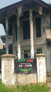
284 m
Shelter Go'han
Cafe
read more
285 m
Warpool (Waroeng Ngoempool)
Jalan Limo Raya No.23, Limo
Cafe
read more
335 m
Warung Kopi
Limo
Cafe
read more
356 m
The Buncitmen Coffee
Jalan Ambon, Cinere
Cafe
read more
356 m
Cafe Atap Laju
Jalan Ambon, Cinere
Cafe
read more
541 m
Dippylicious
Jalan Limo Raya RT 03 RW 05 #86 Limo, Limo
Cafe
read more
676 m
Cafe ugig
Jalan Masjid No.3, Cinere
Cafe
read more
684 m
Warkop Nandah
Jalan Garuda Ujung, Limo
Cafe
read more
688 m
Warkop Bumi Ayu
Jalan Garuda Ujung #162A Cinere Limo, Limo
Cafe
read more
715 m
Warung Bapongka
Pondok Cabe Udik
Cafe
read more
737 m
Warkop Nongkrong Kalangan Remaja Indonesia
Limo
Cafe
read more
737 m
Warkop Nongkrong Kalangan Remaja Indonesia
Indonesia
Cafe
read more
753 m
Deaf Cafe Fingertalk
Jalan Cinere Raya No.26-29, Cinere
Cafe
read more
770 m
Grand Cinere C7
Jalan Pinang Dua, Limo
Cafe
read more
829 m
Warung TAKOYAKI /SEBLAK
Jalan Kayu Manis Raya, Pondok Cabe Udik
Cafe
read more
851 m
CentralPark The Palm, Modernhill
Unnamed Road, Pondok Cabe Udik
Cafe
read more
867 m
BeDee Cafe & Kedai Mis-u
Blok OD No.54, Jalan Cinere Raya, Cinere
Cafe
read more
890 m
Wardi Niken
Cafe
read more
897 m
Misu kopsurat
Magelang, Jl. Raya cinere Blok F1 No 10 A Lantai 1 diatas kupat tahu cinere
Cafe
read more
901 m
Dapur Si Princess
griya cinere 1, Jalan Parkit I Blok B4 No.28, Limo
Cafe
read more
918 m
Cloud Nine Cakery
Jalan Alam Pesanggrahan I No.25, Cinere
Cafe
read more
1.348 km
Ketupat Sayur Padang UNI MELLY
Bukit Selatan 13 Blok g No.17, Cinangka
Cafe
read more
📑
all categories
Accounting
Administrative area level 1
Administrative area level 2
Airport
Amusement park
Aquarium
Art gallery
Atm
Bakery
Bank
Bar
Beauty salon
Bicycle store
Book store
Bowling alley
Bus station
Cafe
Campground
Car dealer
Car rental
Car repair
Car wash
Casino
Cemetery
Church
City hall
Clothing store
Colloquial area
Convenience store
Courthouse
Dentist
Department store
Doctor
Electrician
Electronics store
Embassy
Finance
Fire station
Florist
Food
Funeral home
Furniture store
Gas station
General contractor
Grocery or supermarket
Gym
Hair care
Hardware store
Health
Hindu Temple
Home goods store
Hospital
Insurance agency
Intersection
Jewelry store
Laundry
Lawyer
Library
Liquor store
Local government office
Locality
Locksmith
Lodging
Meal delivery
Meal takeaway
Mosque
Movie rental
Movie theater
Moving company
Museum
Natural feature
Neighborhood
Night club
Painter
Park
Parking
Pet store
Pharmacy
Physiotherapist
Place of worship
Plumber
Point of interest
Police
Political
Post office
Premise
Real estate agency
Restaurant
Roofing contractor
Route
Rv park, camping
School
Shoe store
Shopping mall
Spa
Stadium
Storage
Store
Subpremise
Supermarket
Synagogue
Taxi stand
Train station
Transit station
Travel agency
University
Veterinary care
Zoo
administrative area level 3
administrative area level 4
administrative area level 5
sublocality level 1
↑