Supermarket nearby Warung Mas Agus
Indonesia
Supermarket nearby Warung Mas Agus
Warung Mas Agus
18, Jalan Teuku Umar, 35123, Kota Bandar Lampung, Lampung, ID Indonesia
contacts phone
:
+62
Latitude:
-5.3956415
, Longitude:
105.2615795
larger map & directions
read more
nearest Supermarket
290 m
Warung Eyang Bobby Jawa
Jalan Danau Tondano, Surabaya
Supermarket
read more
349 m
Warung Bang Yura
Sidodadi
Supermarket
read more
363 m
INDOMARET Teuku Umar
Jalan Teuku Umar No.21, Sidodadi
Supermarket
read more
372 m
Warung Mully
Sidodadi
Supermarket
read more
389 m
Warung Bang Ali
Sidodadi
Supermarket
read more
405 m
Bintang Mart
Jalan Badak, Sidodadi
Supermarket
read more
503 m
Badak Mart
Sidodadi
Supermarket
read more
584 m
Warung Reyhan
Gang Sejahtera No.10, Sidodadi
Supermarket
read more
600 m
WR TAWAKKAL
jl. Pandawa Raya No. 112 Korpri Jaya, Jagabaya II
Supermarket
read more
661 m
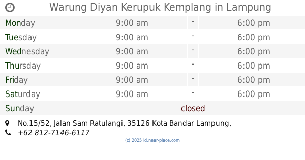
Warung Diyan Kerupuk Kemplang
Jalan Sam Ratulangi No.15/52, Penengahan
Supermarket
read more
672 m
Warung Ayu
Jalan Danau Towuti, Surabaya
Supermarket
read more
706 m
Indomaret Teuku Umar 2
Jalan Teuku Umar No.11a, Sidodadi
Supermarket
read more
727 m
GENTA ANJANI
Gang Selada 2 No.43, Jagabaya II
Supermarket
read more
788 m
lontong pak kentus
Gang Inabah No, 168, Jalan Danau Towuti, Surabaya
Supermarket
read more
850 m
Warung Umi Lia
A, Jalan Tomat No.26, Jagabaya II
Supermarket
read more
872 m
Kolam Pemancingan Gobang Berkah Dan Warung Grosir Sembako
Unnamed Road, Sukamenanti
Supermarket
read more
876 m
warung zainal
Jaga Baya I
Supermarket
read more
979 m
Toko Helm Rido Jaya Pajajran
Jalan Pajajaran No.157b, Gunung Sulah
Supermarket
read more
985 m
Zea R Q
Jalan Narada No.23, Sawah Brebes
Supermarket
read more
1.078 km
Src Swalayan Dina
Jalan Urip Sumoharjo No.66, Surabaya
Supermarket
read more
1.179 km
WARUNG DEWI
Gunung Sulah
Supermarket
read more
1.297 km
Warung Amel
Gang Setia, Gunung Sulah
Supermarket
read more
1.782 km
LAMBAN Design
Jalan Imam Bonjol Gang Beringin No. 43 Lebak Manis Sukajawa Baru, Suka Jawa
Supermarket
read more
1.832 km
Toko Horison Jaya Bambu Kuning
Jalan Bukit Tinggi No.19D, Kelapa Tiga
Supermarket
read more
2.11 km
SUSANTO FISHING
Tanjung Baru
Supermarket
read more
📑
all categories
Accounting
Administrative area level 1
Administrative area level 2
Airport
Amusement park
Aquarium
Art gallery
Atm
Bakery
Bank
Bar
Beauty salon
Bicycle store
Book store
Bowling alley
Bus station
Cafe
Campground
Car dealer
Car rental
Car repair
Car wash
Casino
Cemetery
Church
City hall
Clothing store
Colloquial area
Convenience store
Courthouse
Dentist
Department store
Doctor
Electrician
Electronics store
Embassy
Finance
Fire station
Florist
Food
Funeral home
Furniture store
Gas station
General contractor
Grocery or supermarket
Gym
Hair care
Hardware store
Health
Hindu Temple
Home goods store
Hospital
Insurance agency
Intersection
Jewelry store
Laundry
Lawyer
Library
Liquor store
Local government office
Locality
Locksmith
Lodging
Meal delivery
Meal takeaway
Mosque
Movie rental
Movie theater
Moving company
Museum
Natural feature
Neighborhood
Night club
Painter
Park
Parking
Pet store
Pharmacy
Physiotherapist
Place of worship
Plumber
Point of interest
Police
Political
Post office
Premise
Real estate agency
Restaurant
Roofing contractor
Route
Rv park, camping
School
Shoe store
Shopping mall
Spa
Stadium
Storage
Store
Subpremise
Supermarket
Synagogue
Taxi stand
Train station
Transit station
Travel agency
University
Veterinary care
Zoo
administrative area level 3
administrative area level 4
administrative area level 5
sublocality level 1
↑