Supermarket nearby Toko Lubuk Raya
Coronavirus disease (COVID-19) Situation
confirmed cases
6829221
deaths
162063
Indonesia
Supermarket nearby Toko Lubuk Raya
Toko Lubuk Raya
Kramat Indonezja
contacts phone
:
+62
Latitude:
-6.0462334
, Longitude:
106.6005205
read more
nearest Supermarket
107 m
Indomaret Kalang Anyar, Kalibaru
Kramat
Supermarket
read more
175 m
Alfamart
Kramat
Supermarket
read more
757 m
Toko H.Predi
Kramat
Supermarket
read more
800 m
Toko Madura (Jaka)
Kramat
Supermarket
read more
927 m
Kode Bengkel (Kairos Abadi Motor)
Jalan Raya Cituis No.5, Kramat
Supermarket
read more
1.379 km
Nazwa Cell
Sukawali
Supermarket
read more
1.834 km
Warung Judin Kumis
Buaran Bambu
Supermarket
read more
1.972 km
Warung Dirli
Buaran Bambu
Supermarket
read more
2.446 km
Warung ABI
Perumahan Pondok Cituis Indah, Ds. Suryabahari, Kec. Pakuhaji, Surya Bahari
Supermarket
read more
2.456 km
Cv. Anugrah Cahaya Putra Mandiri
Jalan Raya BTN Cituis Indah No.E no.26, Surya Bahari
Supermarket
read more
2.598 km
Warung Bang Kuya
Buaran Bambu
Supermarket
read more
2.633 km
Tatashop
Jalan Laksana, Buaran Bambu
Supermarket
read more
2.692 km
Warung Rokok Ibu Onih
Jalan Raya Kali Baru No.raya, Pangkalan
Supermarket
read more
2.82 km
(SAHABAT STEAM)
Kohod
Supermarket
read more
2.839 km
Toko Oong
Surya Bahari
Supermarket
read more
2.935 km
Toko Jaelani
Surya Bahari
Supermarket
read more
3.378 km
Toko Sembako Bpk. Fendi 38
Paku Alam
Supermarket
read more
3.55 km
Warung Jihan
Jalan Raya Tanjung Burung, Tanjung Burung
Supermarket
read more
3.551 km
Toko Sembako Hj. Yuyun H.Dadang
Paku Alam
Supermarket
read more
4.645 km
Warung Bang Panca
Jalan Rawa Badak, Laksana
Supermarket
read more
4.765 km
Warung Bang Tarip
Laksana
Supermarket
read more
4.962 km
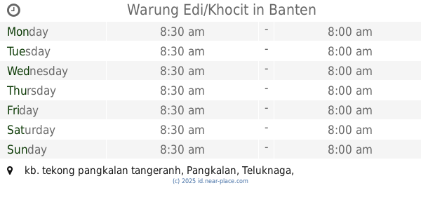
Warung Edi/Khocit
kb. tekong pangkalan tangeranh, Pangkalan
Supermarket
read more
5.245 km
toko Rahayu Jaya - Iwan
Gaga
Supermarket
read more
5.493 km
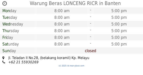
Warung Beras LONCENG RICR
Jl. Teladan II No.28, (belakang koramil) Kp. Melayu Barat, 15510, Kampung Melayu Barat
Supermarket
read more
5.562 km
Warung Teh lia
Jalan Kampung Kalijaya, Kampung Melayu Barat
Supermarket
read more
📑
all categories
Accounting
Administrative area level 1
Administrative area level 2
Airport
Amusement park
Aquarium
Art gallery
Atm
Bakery
Bank
Bar
Beauty salon
Bicycle store
Book store
Bowling alley
Bus station
Cafe
Campground
Car dealer
Car rental
Car repair
Car wash
Casino
Cemetery
Church
City hall
Clothing store
Colloquial area
Convenience store
Courthouse
Dentist
Department store
Doctor
Electrician
Electronics store
Embassy
Finance
Fire station
Florist
Food
Funeral home
Furniture store
Gas station
General contractor
Grocery or supermarket
Gym
Hair care
Hardware store
Health
Hindu Temple
Home goods store
Hospital
Insurance agency
Intersection
Jewelry store
Laundry
Lawyer
Library
Liquor store
Local government office
Locality
Locksmith
Lodging
Meal delivery
Meal takeaway
Mosque
Movie rental
Movie theater
Moving company
Museum
Natural feature
Neighborhood
Night club
Painter
Park
Parking
Pet store
Pharmacy
Physiotherapist
Place of worship
Plumber
Point of interest
Police
Political
Post office
Premise
Real estate agency
Restaurant
Roofing contractor
Route
Rv park, camping
School
Shoe store
Shopping mall
Spa
Stadium
Storage
Store
Subpremise
Supermarket
Synagogue
Taxi stand
Train station
Transit station
Travel agency
University
Veterinary care
Zoo
administrative area level 3
administrative area level 4
administrative area level 5
sublocality level 1
↑