Supermarket nearby Si Kancil Cell
Indonesia
Supermarket nearby Si Kancil Cell
Si Kancil Cell
kp, Jalan Dadap Bubulak RT.003/RW.002, Pangadegan Indonesia
contacts phone
:
+62
Latitude:
-6.134165
, Longitude:
106.5568947
read more
nearest Supermarket
9 m
Lestari Alam Duck
Kp, Dadap Rt. 003, 002, Pangadegan
Supermarket
read more
920 m
Warung Bu Mahpujoh
Unnamed Road, Pangadegan
Supermarket
read more
968 m
RikaJaya Depot Air Minum Isi Ulang
Pangadegan
Supermarket
read more
1.048 km
Agen Telur Barkah
Sukasari
Supermarket
read more
1.177 km
clontreng shop iwan
Pangadegan
Supermarket
read more
1.883 km
tk ayam bp sidup
Kampung Bolang, Sukasari
Supermarket
read more
1.883 km
Toko Ayam Bp Sidup
Kampung Bolang, Sukasari
Supermarket
read more
1.954 km
Warung Pak ILHAM
Jalan Panorama Hijau, Sukamantri
Supermarket
read more
1.973 km
Farhan Cosmetik
Sukamantri
Supermarket
read more
2.054 km
warung mirja
Mekarsari
Supermarket
read more
2.057 km
warung al inayah 1
Unnamed Road, Sukasari
Supermarket
read more
2.058 km
Warung Pak Agus
Kutabumi
Supermarket
read more
2.132 km
Warung H. Jenal
Sukasari
Supermarket
read more
2.19 km
Zahra Store
taman raya rajeg blok i5/27, Mekarsari
Supermarket
read more
2.467 km
Warung Lulud
Jalan Pesut I, Kuta Baru
Supermarket
read more
2.488 km
Warung Mama Tiwi
Unnamed Road, Mekarsari
Supermarket
read more
2.526 km
Warung Ibu Ani
Jalan Pesut I Blok B24 No.22, Kuta Baru
Supermarket
read more
2.631 km
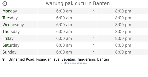
warung pak cucu
Unnamed Road, Pisangan Jaya
Supermarket
read more
2.685 km
SME'sCo Mart
Jalan Raya Mauk No.428, Sepatan
Supermarket
read more
2.741 km
Alfamidi Sepatan
Jalan Raya Mauk No.428, Sepatan
Supermarket
read more
2.772 km
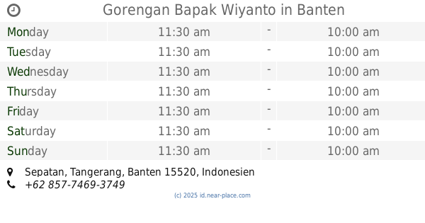
Gorengan Bapak Wiyanto
Sepatan
Supermarket
read more
2.845 km
Alfamart Sepatan 3
Jalan Raya Mauk, Pisangan Jaya
Supermarket
read more
2.963 km
indomaret mekarsari rajeg
Mekarsari
Supermarket
read more
3.085 km
Warung Jurai SN
Pisangan Jaya
Supermarket
read more
3.326 km
Warung Pak Kumis
Rajeg Mulya
Supermarket
read more
📑
all categories
Accounting
Administrative area level 1
Administrative area level 2
Airport
Amusement park
Aquarium
Art gallery
Atm
Bakery
Bank
Bar
Beauty salon
Bicycle store
Book store
Bowling alley
Bus station
Cafe
Campground
Car dealer
Car rental
Car repair
Car wash
Casino
Cemetery
Church
City hall
Clothing store
Colloquial area
Convenience store
Courthouse
Dentist
Department store
Doctor
Electrician
Electronics store
Embassy
Finance
Fire station
Florist
Food
Funeral home
Furniture store
Gas station
General contractor
Grocery or supermarket
Gym
Hair care
Hardware store
Health
Hindu Temple
Home goods store
Hospital
Insurance agency
Intersection
Jewelry store
Laundry
Lawyer
Library
Liquor store
Local government office
Locality
Locksmith
Lodging
Meal delivery
Meal takeaway
Mosque
Movie rental
Movie theater
Moving company
Museum
Natural feature
Neighborhood
Night club
Painter
Park
Parking
Pet store
Pharmacy
Physiotherapist
Place of worship
Plumber
Point of interest
Police
Political
Post office
Premise
Real estate agency
Restaurant
Roofing contractor
Route
Rv park, camping
School
Shoe store
Shopping mall
Spa
Stadium
Storage
Store
Subpremise
Supermarket
Synagogue
Taxi stand
Train station
Transit station
Travel agency
University
Veterinary care
Zoo
administrative area level 3
administrative area level 4
administrative area level 5
sublocality level 1
↑