Supermarket nearby Konter Ayo Cellular
Indonesia
Supermarket nearby Konter Ayo Cellular
Konter Ayo Cellular
Gintung, Sukadiri, Tangerang, Banten 15330, Indonesien
contacts phone
:
+62
Latitude:
-6.0954136
, Longitude:
106.5566124
larger map & directions
read more
nearest Supermarket
548 m
Mauk alfamart Gintung
Jalan Raya Mauk, Gintung
Supermarket
read more
573 m
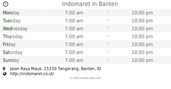
Indomaret Kosambi Sepatan
Jalan Raya Mauk, Sepatan
Supermarket
read more
1.223 km
Toko Arum Jaya H.santoso
Kosambi
Supermarket
read more
1.285 km
Zhian Susu
Unnamed Road,, Kosambi
Supermarket
read more
1.414 km
Indomaret
Jalan Raya Mauk, Kosambi
Supermarket
read more
1.548 km
Alfamart
Jatiwaringin
Supermarket
read more
1.732 km
warung al inayah madura
Pisangan Jaya
Supermarket
read more
1.774 km
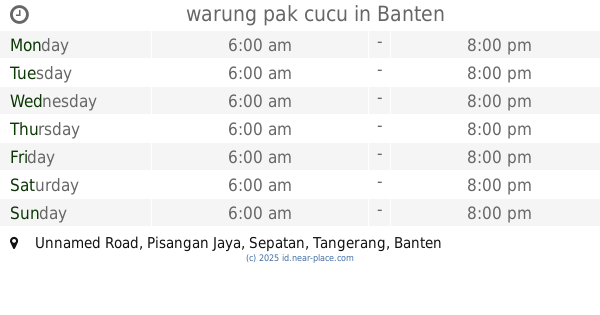
warung pak cucu
Unnamed Road, Pisangan Jaya
Supermarket
read more
1.787 km
Warung Wa Kari
Sukasari
Supermarket
read more
1.841 km
toko sederhana 3
Jalan Raya Mauk, Jatiwaringin
Supermarket
read more
1.9 km
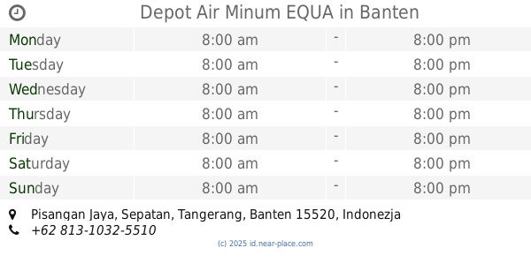
Depot Air Minum EQUA
Pisangan Jaya
Supermarket
read more
1.908 km
Warung Naufal I512a
Pisangan Jaya
Supermarket
read more
1.958 km
Toko Toni
Jalan Jati Tanjakan, Jatiwaringin
Supermarket
read more
1.966 km
Warung Jurai SN
Pisangan Jaya
Supermarket
read more
1.979 km
Warung Nurina
Jalan Raya Mauk, Banyu Asih
Supermarket
read more
2.042 km
Alfa Mart
Jalan Ahmad Yani No.16, Pisangan Jaya
Supermarket
read more
2.064 km
Gardenia alfamart Sepatan
Jalan Raya Mauk, Sepatan, Pisangan Jaya
Supermarket
read more
2.17 km
Toko Rayhan
Perumahan, Grand Permata, Jln, GPS RAYA VI, Blok:EA/4, RT.11/RW.10, Pisangan Jaya
Supermarket
read more
2.339 km
Warung H. Jenal
Sukasari
Supermarket
read more
2.421 km
warung al inayah 1
Unnamed Road, Sukasari
Supermarket
read more
2.55 km
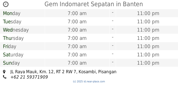
Gem Indomaret Sepatan
JL Raya Mauk, Km. 12, RT 2 RW 7, Kosambi, Pisangan Jaya, Sepatan, Rawa Kidang
Supermarket
read more
2.595 km
Alfamart Sepatan 3
Jalan Raya Mauk, Pisangan Jaya
Supermarket
read more
2.637 km
TOKO SUSU FABIAN
Jalan Raya Mauk, Kedung Dalem
Supermarket
read more
2.914 km
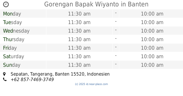
Gorengan Bapak Wiyanto
Sepatan
Supermarket
read more
3.799 km
indomaret mekarsari rajeg
Mekarsari
Supermarket
read more
📑
all categories
Accounting
Administrative area level 1
Administrative area level 2
Airport
Amusement park
Aquarium
Art gallery
Atm
Bakery
Bank
Bar
Beauty salon
Bicycle store
Book store
Bowling alley
Bus station
Cafe
Campground
Car dealer
Car rental
Car repair
Car wash
Casino
Cemetery
Church
City hall
Clothing store
Colloquial area
Convenience store
Courthouse
Dentist
Department store
Doctor
Electrician
Electronics store
Embassy
Finance
Fire station
Florist
Food
Funeral home
Furniture store
Gas station
General contractor
Grocery or supermarket
Gym
Hair care
Hardware store
Health
Hindu Temple
Home goods store
Hospital
Insurance agency
Intersection
Jewelry store
Laundry
Lawyer
Library
Liquor store
Local government office
Locality
Locksmith
Lodging
Meal delivery
Meal takeaway
Mosque
Movie rental
Movie theater
Moving company
Museum
Natural feature
Neighborhood
Night club
Painter
Park
Parking
Pet store
Pharmacy
Physiotherapist
Place of worship
Plumber
Point of interest
Police
Political
Post office
Premise
Real estate agency
Restaurant
Roofing contractor
Route
Rv park, camping
School
Shoe store
Shopping mall
Spa
Stadium
Storage
Store
Subpremise
Supermarket
Synagogue
Taxi stand
Train station
Transit station
Travel agency
University
Veterinary care
Zoo
administrative area level 3
administrative area level 4
administrative area level 5
sublocality level 1
↑