Supermarket nearby Alfamart
Indonesia
Supermarket nearby Alfamart
Alfamart
26, Jalan Taman Kirana Surya, 15730, Tangerang, Banten, ID Indonesia
contacts phone
:
+62 1 500 959
website:
alfamartku.com
Latitude:
-6.2950983
, Longitude:
106.4172233
larger map & directions
read more
nearest Supermarket
263 m
Yayan Cell
Jalan Raya Cisoka, Pasanggrahan
Supermarket
read more
358 m
Toko Sarmin
Solear
Supermarket
read more
680 m
Toko sembako teteh iceu
Unnamed Road, Pasanggrahan
Supermarket
read more
783 m
Warung Azdra Pane
Jalan Raya Cisoka No.6500, Pasanggrahan
Supermarket
read more
982 m
Warung Begeng RT Edih
cirahong, Cikareo
Supermarket
read more
984 m
Pasanggrahan Poultry Shop
Jalan Raya Cibogo, Pasanggrahan
Supermarket
read more
1.024 km
Toko Dian
kp.ancol, Cikareo
Supermarket
read more
1.295 km
Halimah Cake "Alfito-aldito"
Supermarket
read more
1.472 km
Pasanggrahan Poultry Shop
Pasanggrahan
Supermarket
read more
1.617 km
Warung Teh Anis
Solear
Supermarket
read more
2.245 km
Indo Berkah Bangunan (Supermarket Bangunan)
Jalan Raya Cisoka, Sukatani
Supermarket
read more
2.683 km
Kodel Mart
Jalan Bantarpanjang - Cikareo, Cileles
Supermarket
read more
2.778 km
Jumantara Anugrah
Cempaka
Supermarket
read more
2.866 km
Warung Bu Endang
perumahan puri adiyasa blok B5 no, 28, Cikuya
Supermarket
read more
3.21 km
warung ibu Abeng
Cileles
Supermarket
read more
3.345 km
WARUNG SABRUL
Jeungjing
Supermarket
read more
3.475 km
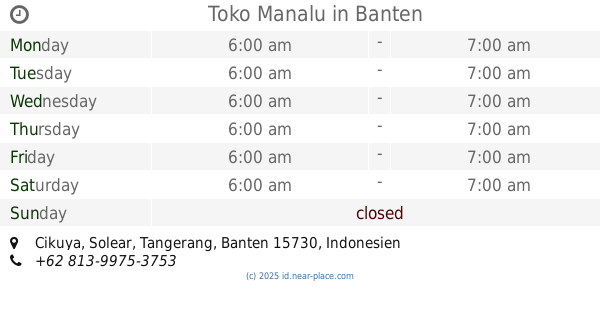
Toko Manalu
Cikuya
Supermarket
read more
3.478 km
Toko Ciki Tris Snack
Pasar
Supermarket
read more
3.579 km
Toko Sendal Dafa
Cempaka
Supermarket
read more
3.586 km
Warung Yusri
Cikasungka
Supermarket
read more
3.677 km
Alfamart Raya Megu
Jalan Cisoka - Megu, Cempaka
Supermarket
read more
3.762 km
Panji Cell
Desa Ranca Sumur, Mekarbaru
Supermarket
read more
3.919 km
Toko Badriyah
Bojongloa, Cisoka
Supermarket
read more
4.153 km
Foto Copy & Pulsa Strom Aki Amanah
Munjul Permai Blok D11 No 51, Munjul
Supermarket
read more
5.084 km
Warung Jeri
Jalan Lingkar Caringin, Caringin
Supermarket
read more
📑
all categories
Accounting
Administrative area level 1
Administrative area level 2
Airport
Amusement park
Aquarium
Art gallery
Atm
Bakery
Bank
Bar
Beauty salon
Bicycle store
Book store
Bowling alley
Bus station
Cafe
Campground
Car dealer
Car rental
Car repair
Car wash
Casino
Cemetery
Church
City hall
Clothing store
Colloquial area
Convenience store
Courthouse
Dentist
Department store
Doctor
Electrician
Electronics store
Embassy
Finance
Fire station
Florist
Food
Funeral home
Furniture store
Gas station
General contractor
Grocery or supermarket
Gym
Hair care
Hardware store
Health
Hindu Temple
Home goods store
Hospital
Insurance agency
Intersection
Jewelry store
Laundry
Lawyer
Library
Liquor store
Local government office
Locality
Locksmith
Lodging
Meal delivery
Meal takeaway
Mosque
Movie rental
Movie theater
Moving company
Museum
Natural feature
Neighborhood
Night club
Painter
Park
Parking
Pet store
Pharmacy
Physiotherapist
Place of worship
Plumber
Point of interest
Police
Political
Post office
Premise
Real estate agency
Restaurant
Roofing contractor
Route
Rv park, camping
School
Shoe store
Shopping mall
Spa
Stadium
Storage
Store
Subpremise
Supermarket
Synagogue
Taxi stand
Train station
Transit station
Travel agency
University
Veterinary care
Zoo
administrative area level 3
administrative area level 4
administrative area level 5
sublocality level 1
↑