School nearby SDN Cangkudu III
Indonesia
School nearby SDN Cangkudu III
SDN Cangkudu III
Cangkudu Indonesien
contacts phone
:
+62
Latitude:
-6.22927
, Longitude:
106.4327799
read more
nearest School
87 m
Bengkel IDI
Jalan Raya Cisoka No.17, Cangkudu
School
read more
128 m
TKQ Ar-Rahmah
Perum Griya Permata Cisoka blok C3,, Cibugel
School
read more
160 m
TK Salsabila
Jalan Raya Serang, Cangkudu
School
read more
163 m
TK Salsabila Bani Said
Ciapus,, Cangkudu
School
read more
379 m
SMP Haradiksa
Perumahan Bukit Gading, Sentul Jaya, Balaraja, Cangkudu
School
read more
418 m
SD Negri Cangkudu 1 & 2
Jalan Raya Serang Cangkudu Balaraja, Cangkudu
School
read more
594 m
SDN Cangkudu IV
Jalan Raya Serang No.6, Cangkudu
School
read more
643 m
TK Waladun Sholeh
Selapajang
School
read more
657 m
TK AN-NUR
Selapajang
School
read more
730 m
SMP CISOKA 2
Cangkudu
School
read more
852 m
SMP HARADIKSA
Selapajang
School
read more
854 m
SDN Curug Kulon III
Selapajang
School
read more
909 m
TPA Dan SDIT Hidayatul Iman
Jalan Raya Serang KM.28, Cangkudu
School
read more
943 m
Pon-pes Almansuriyah
Selapajang
School
read more
1.029 km
SDN Slapajang IV
Selapajang
School
read more
1.101 km
Pesantren Darussalam
kp.nagrak rt.02/03, Gembong
School
read more
1.109 km
SDN Selapanjang 3
JL Raya Cangkudu - Cisoka, Km. 2, Kampung Panggang, Cisoka, Selapajang
School
read more
1.286 km
Ponpes Alfalahiyah Bani Ardani
Jalan Raya Cisoka No.68, Selapajang
School
read more
1.302 km
MIS AL HUSNA
Sentul
School
read more
1.711 km
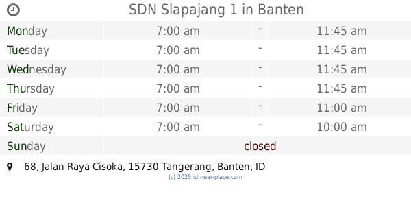
SDN Slapajang 1
Jalan Raya Cisoka No.68, Selapajang
School
read more
1.712 km
SD N Salapajang
Jalan Raya Cisoka No.68, Selapajang
School
read more
1.716 km
SDN Nagrog
Selapajang
School
read more
2.032 km
Sdn Sukamurni 2
Suka Murni
School
read more
2.803 km
SDN Jalupang
Cisereh
School
read more
3.399 km
SD Negeri Pete
Tegalsari, Tigaraksa, Tegalsari
School
read more
📑
all categories
Accounting
Administrative area level 1
Administrative area level 2
Airport
Amusement park
Aquarium
Art gallery
Atm
Bakery
Bank
Bar
Beauty salon
Bicycle store
Book store
Bowling alley
Bus station
Cafe
Campground
Car dealer
Car rental
Car repair
Car wash
Casino
Cemetery
Church
City hall
Clothing store
Colloquial area
Convenience store
Courthouse
Dentist
Department store
Doctor
Electrician
Electronics store
Embassy
Finance
Fire station
Florist
Food
Funeral home
Furniture store
Gas station
General contractor
Grocery or supermarket
Gym
Hair care
Hardware store
Health
Hindu Temple
Home goods store
Hospital
Insurance agency
Intersection
Jewelry store
Laundry
Lawyer
Library
Liquor store
Local government office
Locality
Locksmith
Lodging
Meal delivery
Meal takeaway
Mosque
Movie rental
Movie theater
Moving company
Museum
Natural feature
Neighborhood
Night club
Painter
Park
Parking
Pet store
Pharmacy
Physiotherapist
Place of worship
Plumber
Point of interest
Police
Political
Post office
Premise
Real estate agency
Restaurant
Roofing contractor
Route
Rv park, camping
School
Shoe store
Shopping mall
Spa
Stadium
Storage
Store
Subpremise
Supermarket
Synagogue
Taxi stand
Train station
Transit station
Travel agency
University
Veterinary care
Zoo
administrative area level 3
administrative area level 4
administrative area level 5
sublocality level 1
↑