School nearby Rumah Ilmu
Coronavirus disease (COVID-19) Situation
confirmed cases
6829221
deaths
162063
Indonesia
School nearby Rumah Ilmu
Rumah Ilmu
2, Jalan Wadas Buntu, 17411, Kota Bekasi, Jawa Barat, ID Indonesia
contacts phone
:
+62 857-2828-2811
website:
www.ngefast.id
Latitude:
-6.2608194
, Longitude:
106.9176686
larger map & directions
read more
nearest School
309 m
Mt.ibadurrahman
Jalan Haji Muhyin No.79-80, Jaticempaka
School
read more
337 m
PAUD Seroja
Jaticempaka
School
read more
550 m
Taman Kanak-Kanak Islam Nurul Ikhlas
Jalan Elang Indopura I No.22, RT.5/RW.8, Cipinang Melayu
School
read more
604 m
SDIT AL AMAL
Jalan Wadas Raya No.105, Jaticempaka
School
read more
677 m
RA/BA/TA Syafi'ul Ikhwan
JL. Kemang Raya, RT. 002 RW. 07 No. 98, Pondok Gede, Jaticempaka
School
read more
704 m
PAUD SOKA
I, Jalan Rawa Indah, Jaticempaka
School
read more
772 m
Paud Seruni
JL. Elang Thanesia, Blok C2-7, RT.2/RW.8, Cipinang Melayu
School
read more
810 m
Kampus UIA
Jalan Raya Jatiwaringin, Jatiwaringin
School
read more
811 m
Kelompok Bermain Tom-Tom Lin
JL. Sentosa, Blok D.II No. 8, Pasirsari, Cikarang Selatan
School
read more
819 m
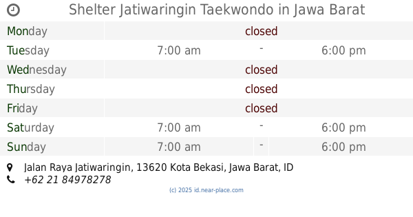
Shelter Jatiwaringin Taekwondo
Jalan Raya Jatiwaringin, Jatiwaringin
School
read more
847 m
SMK Mitra Nusantara
Jalan Kemang Raya No.53G, RT.5/RW.7, Jatibening Baru
School
read more
856 m
Jami Masjid Al-Marzukiyah
Jalan Kemang Raya No.12, Jatibening Baru
School
read more
860 m
MIS Al Marzukiyah
JL. Raya Kemang, No. 12, Jati Cempaka, Pondok Gede, Jatibening Baru
School
read more
886 m
Agit dan lina
Jalan Raya Jatiwaringin, Jatiwaringin
School
read more
899 m
Sekolah Menengah Kejuruan Pembangunan Nasional Bekasi
Jalan Setia 1 No.86, RT.03/RW.018, Jaticempaka
School
read more
900 m
Madrasah Aliyah Assyafiiyah 2
Jl. Jatiwaringin Raya 8 RT 010 RW 05 Jati Waringin Pondok Gede Bekasi Jawa Barat, Jatimakmur
School
read more
911 m
Akademi Keperawatan As-Syafi'Iyah
Jalan Rawa Indah No.05, Jaticempaka
School
read more
934 m
TK Orchid
JL Selecta, Blok C12 No. 99, Jaticempaka
School
read more
961 m
Sekolah Menengah Pertama Islam As-Syafiiyah 04
Jalan Raya Jatiwaringin No.45, Jaticempaka
School
read more
991 m
Bimbel MEDIKA Plus
Jalan Delta Zamrud No.190, Jatiwaringin
School
read more
1.008 km
Pondok Pesantren Hudatul Ummah
Jalan Masjid Raya No.88, RT.4/RW.19, Jaticempaka
School
read more
1.047 km
SD Muslim Brotherhood Syafiul
Jalan Syafiul Ikhwan RT.007/02, No. 45, Jaticempaka, Pondokgede, Jatibening Baru, Kota Bks
School
read more
1.065 km
Merin Math
blok f no 13450, Jalan Permata Timur Raya Blok F No.8, RT.1/RW.8, Pondok Kelapa
School
read more
1.097 km
Warbune Jakarta
1, RT.1/RW.8, Pondok Kelapa
School
read more
1.3 km
PRIMAGAMA KALIMALANG
Jalan Raya Jatiwaringin No.2, RT.4/RW.5, Cipinang Melayu
School
read more
📑
all categories
Accounting
Administrative area level 1
Administrative area level 2
Airport
Amusement park
Aquarium
Art gallery
Atm
Bakery
Bank
Bar
Beauty salon
Bicycle store
Book store
Bowling alley
Bus station
Cafe
Campground
Car dealer
Car rental
Car repair
Car wash
Casino
Cemetery
Church
City hall
Clothing store
Colloquial area
Convenience store
Courthouse
Dentist
Department store
Doctor
Electrician
Electronics store
Embassy
Finance
Fire station
Florist
Food
Funeral home
Furniture store
Gas station
General contractor
Grocery or supermarket
Gym
Hair care
Hardware store
Health
Hindu Temple
Home goods store
Hospital
Insurance agency
Intersection
Jewelry store
Laundry
Lawyer
Library
Liquor store
Local government office
Locality
Locksmith
Lodging
Meal delivery
Meal takeaway
Mosque
Movie rental
Movie theater
Moving company
Museum
Natural feature
Neighborhood
Night club
Painter
Park
Parking
Pet store
Pharmacy
Physiotherapist
Place of worship
Plumber
Point of interest
Police
Political
Post office
Premise
Real estate agency
Restaurant
Roofing contractor
Route
Rv park, camping
School
Shoe store
Shopping mall
Spa
Stadium
Storage
Store
Subpremise
Supermarket
Synagogue
Taxi stand
Train station
Transit station
Travel agency
University
Veterinary care
Zoo
administrative area level 3
administrative area level 4
administrative area level 5
sublocality level 1
↑