School nearby Project
Indonesia
School nearby Project
Project
79, Jalan Pinang Raya, 15417, Kota Tangerang Selatan, Banten, ID Indonesia
contacts phone
:
+62 838-0807-7045
Latitude:
-6.3592222
, Longitude:
106.7381481
larger map & directions
read more
nearest School
306 m
Pondok Pesantren Al-Adzkar Pamulang
Jalan Pinang Raya No.29, Pamulang Timur
School
read more
321 m
Mental Aritmatika
JL Durian I, Pamulang, Komplek Pamulang Estate, Pamulang Timur
School
read more
330 m
SLTP ARRAISSIYAH
Bar., Pamulang Barat
School
read more
560 m
Sekolah Dasar Negeri Pamulang V
Jalan Kemuning 3 No.21, RT.1/RW.6, Pamulang Barat
School
read more
666 m
PKBM HIMATS
Jalan Suryakencana No.37, Pamulang Barat
School
read more
672 m
Integrated Islamic Preschool
Jalan Nangka 1, Pamulang Timur
School
read more
687 m
Taman Bacaan Daun Kelapa
Pondok Petir
School
read more
705 m
Sekolah Menengah Atas Al-Ma’mun Education Center-2
Jalan Haji Nawi Malik No.14, RT.1/RW.4, Pondok Petir
School
read more
711 m
Rumah Majesty
Jalan Nangka 1 Blok F2 No. 28 East Pamulang, Pamulang Timur, Pamulang, Pamulang Timur
School
read more
766 m
Sekolah Menengah Pertama Muhammadiyah 22 Pamulang
Jalan Tanjung, Serua
School
read more
775 m
SDIT Az - Zahra
Jalan Tanjung, Serua
School
read more
797 m
YPB 45 TK UMMI
West Pamulang
School
read more
808 m
Syarifa Daycare Depok
Unnamed Road, Serua
School
read more
841 m
Madrasah Tsanawiyah Daarul Hikmah
Jalan Suryakencana No.24, RT.5/RW.5, Pamulang Barat
School
read more
846 m
Madrasah Aliyah Daarul Hikmah
Jalan Suryakencana No.24, RT.5/RW.5, Pamulang Barat
School
read more
888 m
Ikhlashul Amin Kindergarten
Jalan Kenari Raya Utama No.4, Pamulang Barat
School
read more
888 m
Tk Ikhlashul Amin
Jalan Kenari Raya Utama No.4, Pamulang Barat
School
read more
938 m
TK lslam Alifah
jl.melati blok A/7 RT01 RW14,pamulang elok,pondok petir, Pondok Petir
School
read more
948 m
TK KUNTUM MAWAR
Jalan Ketapang 3 No.136, Pamulang Barat
School
read more
999 m
The Progressive School of Islam
Jalan Suryakencana No.71, Pamulang Barat
School
read more
1.01 km
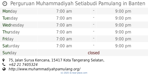
Perguruan Muhammadiyah Setiabudi Pamulang
Jalan Surya Kencana No.75, Pamulang Barat
School
read more
1.03 km
Sekolah Menengah Atas Kharismawita
Jalan Raya Parung-Ciputat No.462, Serua
School
read more
1.035 km
Matriks Pamulang
Jalan Suryakencana Blok Haji Mutiri No.71, Pamulang Barat
School
read more
1.052 km
PUSDIKLAT PEGAWAI KEMENTRIAN PENDIKIKAN DAN KEBUDAYAAN
Jalan Raya Parung-Ciputat, Kedaung
School
read more
1.111 km
SD Serua 3
JL. Serua Raya, RT. 001 RW. 05, Serua
School
read more
📑
all categories
Accounting
Administrative area level 1
Administrative area level 2
Airport
Amusement park
Aquarium
Art gallery
Atm
Bakery
Bank
Bar
Beauty salon
Bicycle store
Book store
Bowling alley
Bus station
Cafe
Campground
Car dealer
Car rental
Car repair
Car wash
Casino
Cemetery
Church
City hall
Clothing store
Colloquial area
Convenience store
Courthouse
Dentist
Department store
Doctor
Electrician
Electronics store
Embassy
Finance
Fire station
Florist
Food
Funeral home
Furniture store
Gas station
General contractor
Grocery or supermarket
Gym
Hair care
Hardware store
Health
Hindu Temple
Home goods store
Hospital
Insurance agency
Intersection
Jewelry store
Laundry
Lawyer
Library
Liquor store
Local government office
Locality
Locksmith
Lodging
Meal delivery
Meal takeaway
Mosque
Movie rental
Movie theater
Moving company
Museum
Natural feature
Neighborhood
Night club
Painter
Park
Parking
Pet store
Pharmacy
Physiotherapist
Place of worship
Plumber
Point of interest
Police
Political
Post office
Premise
Real estate agency
Restaurant
Roofing contractor
Route
Rv park, camping
School
Shoe store
Shopping mall
Spa
Stadium
Storage
Store
Subpremise
Supermarket
Synagogue
Taxi stand
Train station
Transit station
Travel agency
University
Veterinary care
Zoo
administrative area level 3
administrative area level 4
administrative area level 5
sublocality level 1
↑