School nearby GlobalComp
Indonesia
School nearby GlobalComp
GlobalComp
Pesona Wibawa Praja blok C3 no.4, Jeungjing Indonesien
contacts phone
:
+62
Latitude:
-6.2610923
, Longitude:
106.4413676
read more
nearest School
222 m
MTSS Asmaul Husna
Jeungjing
School
read more
258 m
Kelompok Bermain Garden Fruits
JL. Tegal Sari
School
read more
393 m
TK/PAUD Khadafi
JL Tigakarsa-Cisoka, RT 022 RW 03, Jeungjing
School
read more
439 m
Yayasan Pendidikan islam Al-Habibah
Jeungjing
School
read more
501 m
MI MTS Asmaul Husana
Jl. Desa Jeungjing Rt 05/03 Cisoka Tangerang Banten, Jeungjing
School
read more
654 m
SD CISOKA 1 2
Jeungjing
School
read more
667 m
SDN Jeungjing 1
Jeungjing
School
read more
699 m
SDN Kadu III
Jeungjing
School
read more
843 m
SDN GURADOG
Pete
School
read more
878 m
SMAN CISOKA
Caringin
School
read more
954 m
MA Swasta Arrohmah
JL. Masjid Agung Arrohmah, Cisoka, Pete
School
read more
960 m
SMP Citra Madinah Cisoka
Caringin
School
read more
1.165 km
SD Negeri Pete
Tegalsari, Tigaraksa, Tegalsari
School
read more
1.353 km
Sdn Munjul 2
Jeungjing
School
read more
1.474 km
SMPS YAPISDA CISOKA
Jalan Raya Cisoka-Tigaraksa, Kp. Saga Rt. 001/001, Caringin
School
read more
1.55 km
SDN Jeungjing 3
Jeungjing
School
read more
1.763 km
Mis Al Mubarok
Jalan Syeh Mubarok, Pete
School
read more
1.815 km
SDN Cisoka III
Cisoka
School
read more
1.86 km
TBM literasi Merah-Putih cisoka
Cisoka
School
read more
1.908 km
SDN Tigaraksa 2
JL Raya Syeh Mubarok, Km. 5, Cisoka, Pete
School
read more
1.966 km
SDN Kadu Tigaraksa
Pete
School
read more
2.014 km
MA Swasta Syekh Mubarok
JL. Raya Taman Adiyasa, KM. 33, Cisoka, Tangerang, Sukatani
School
read more
2.315 km
SMPN 4 TIGARAKSA
Unnamed Road, Pete
School
read more
2.328 km
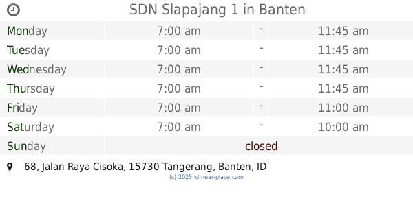
SDN Slapajang 1
Jalan Raya Cisoka No.68, Selapajang
School
read more
2.377 km
SDN Nagrog
Selapajang
School
read more
📑
all categories
Accounting
Administrative area level 1
Administrative area level 2
Airport
Amusement park
Aquarium
Art gallery
Atm
Bakery
Bank
Bar
Beauty salon
Bicycle store
Book store
Bowling alley
Bus station
Cafe
Campground
Car dealer
Car rental
Car repair
Car wash
Casino
Cemetery
Church
City hall
Clothing store
Colloquial area
Convenience store
Courthouse
Dentist
Department store
Doctor
Electrician
Electronics store
Embassy
Finance
Fire station
Florist
Food
Funeral home
Furniture store
Gas station
General contractor
Grocery or supermarket
Gym
Hair care
Hardware store
Health
Hindu Temple
Home goods store
Hospital
Insurance agency
Intersection
Jewelry store
Laundry
Lawyer
Library
Liquor store
Local government office
Locality
Locksmith
Lodging
Meal delivery
Meal takeaway
Mosque
Movie rental
Movie theater
Moving company
Museum
Natural feature
Neighborhood
Night club
Painter
Park
Parking
Pet store
Pharmacy
Physiotherapist
Place of worship
Plumber
Point of interest
Police
Political
Post office
Premise
Real estate agency
Restaurant
Roofing contractor
Route
Rv park, camping
School
Shoe store
Shopping mall
Spa
Stadium
Storage
Store
Subpremise
Supermarket
Synagogue
Taxi stand
Train station
Transit station
Travel agency
University
Veterinary care
Zoo
administrative area level 3
administrative area level 4
administrative area level 5
sublocality level 1
↑