Police nearby Pospol Pondok Indah
Coronavirus disease (COVID-19) Situation
confirmed cases
6829221
deaths
162063
Indonesia
Police nearby Pospol Pondok Indah
Pospol Pondok Indah
Jalan Metro Pondok Indah, 12310, Kota Jakarta Selatan, Daerah Khusus Ibukota Jakarta, ID Indonesia
contacts phone
:
+62 21 7512175
Latitude:
-6.275959
, Longitude:
106.781886
larger map & directions
read more
nearest Police
127 m
Kepolisian Negara Republik Indonesia
Jalan Metro Pondok Indah SB 2, Kebayoran Lama, RT.2/RW.15, Pondok Pinang
Police
read more
317 m
Polisi Pondok Pinang
Jalan Alam Asri II Blok Sb No.10, RT.11/RW.15, Pondok Pinang
Police
read more
1.449 km
Kantor PJR Jaya 4
RT.5/RW.7, Bintaro
Police
read more
1.493 km
Polsek CILANDAK
Jalan Caringin Utara No.1, RT.15/RW.10, Cilandak Barat
Police
read more
1.493 km
Polsek CILANDAK
Jalan Caringin Utara No.1, Cilandak Barat, Cilandak
Police
read more
1.513 km
Polsek Cilandak
Jalan Caringin Utara, RT.15/RW.10, Cilandak Barat, Cilandak, RT.15/RW.10, Cilandak Barat
Police
read more
1.714 km
Pospol Pondok Labu
Jalan Rs. Fatmawati RT.3/RW.10, Cilandak Barat
Police
read more
1.742 km
Police Sespimma Hall
Jalan Ciputat Raya No.30, RT.6 / RW.9, Pondok Pinang, Kebayoran Lama, RT.1/RW.9, Pondok Pinang
Police
read more
1.797 km
Markas Besar Kepolisian Negara Republik
RT.1/RW.9, Pondok Pinang
Police
read more
1.995 km
Dormitory Khusus Sepolwan
Jalan Cempaka No.143, RT.8/RW.9, Pondok Pinang
Police
read more
2.05 km
Polisi Pos
Jalan Djunaedi RT.2/RW.3, Cipete Selatan
Police
read more
2.789 km
Pos Polisi Metropolitan
Jalan Gaharu I No.15, RT.9/RW.4, Cilandak Barat
Police
read more
2.895 km
Pos Polisi / Bkpm
Jalan Bdn Raya RT.6/RW.1, Cipete Selatan
Police
read more
2.902 km
Police Bintaro V
Jl. Bintaro V, RT.8/RW.10, Bintaro
Police
read more
2.918 km
Polsek Kebayoran Lama
Jalan Praja II No.1, RT 05 / RW 01, Kebayoran Lama Selatan, Kebayoran Lama, RT.5/RW.1, Kebayoran Lama Selatan
Police
read more
2.936 km
Pospol Bintaro Jaya
Jalan Bintaro Taman Barat No.18, RT.15/RW.8, Bintaro
Police
read more
2.989 km
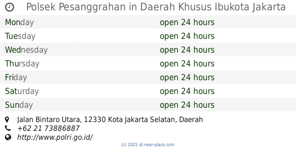
Polsek Pesanggrahan
Jalan Bintaro Utara RT.11/RW.8, Bintaro
Police
read more
2.989 km
Polsek Pesangrahan
RT.9/RW.2, Pesanggrahan
Police
read more
3.116 km
South Jakarta Metro Police
Jalan Wijaya II No.42, RT.2/RW.1, Pulo
Police
read more
3.26 km
Pos Lantas Fatmawati
Jl. Raya Fatmawati
Police
read more
3.422 km
Pospol Permai
Jalan delman elok lV No.14, RT.6/RW.1, Pesanggrahan
Police
read more
4.312 km
Pos Polisi Pondok Ranji
Pondok Ranji
Police
read more
4.339 km
Polsek Pondok Labu
Jalan Margasatwa Blok Hj. Saleh No.10, RT.15/RW.1, Pondok Labu
Police
read more
4.652 km
Pospol Pejaten
Jalan Pejaten Barat RT.2/RW.8, Pejaten Barat
Police
read more
5.711 km
Pospol Ragunan
Jl. Kebon Binatang, RT.10/RW.7, Ragunan
Police
read more
📑
all categories
Accounting
Administrative area level 1
Administrative area level 2
Airport
Amusement park
Aquarium
Art gallery
Atm
Bakery
Bank
Bar
Beauty salon
Bicycle store
Book store
Bowling alley
Bus station
Cafe
Campground
Car dealer
Car rental
Car repair
Car wash
Casino
Cemetery
Church
City hall
Clothing store
Colloquial area
Convenience store
Courthouse
Dentist
Department store
Doctor
Electrician
Electronics store
Embassy
Finance
Fire station
Florist
Food
Funeral home
Furniture store
Gas station
General contractor
Grocery or supermarket
Gym
Hair care
Hardware store
Health
Hindu Temple
Home goods store
Hospital
Insurance agency
Intersection
Jewelry store
Laundry
Lawyer
Library
Liquor store
Local government office
Locality
Locksmith
Lodging
Meal delivery
Meal takeaway
Mosque
Movie rental
Movie theater
Moving company
Museum
Natural feature
Neighborhood
Night club
Painter
Park
Parking
Pet store
Pharmacy
Physiotherapist
Place of worship
Plumber
Point of interest
Police
Political
Post office
Premise
Real estate agency
Restaurant
Roofing contractor
Route
Rv park, camping
School
Shoe store
Shopping mall
Spa
Stadium
Storage
Store
Subpremise
Supermarket
Synagogue
Taxi stand
Train station
Transit station
Travel agency
University
Veterinary care
Zoo
administrative area level 3
administrative area level 4
administrative area level 5
sublocality level 1
↑