Pharmacy nearby Sejahtera
Indonesia
Pharmacy nearby Sejahtera
Sejahtera
Jalan Teuku Umar No.80 B, Penengahan Indonesia
contacts phone
:
+62
Latitude:
-5.401667
, Longitude:
105.2608209
read more
nearest Pharmacy
31 m
Apotek Unggul Arum
Jalan Teuku Umar No.96, Penengahan
Pharmacy
read more
171 m
Apotek Agung
Jalan Sam Ratulangi No.27, Penengahan
Pharmacy
read more
208 m
PENTOL PEDAS BDL
Gang Patriot, Penengahan
Pharmacy
read more
211 m
Apotek Dinata
Jalan Dr. Sutomo No.8, Penengahan
Pharmacy
read more
217 m
Austen Jaya Utama. PT
JL. Teuku Umar, No.99/A, Bandar Lampung, Penengahan
Pharmacy
read more
417 m
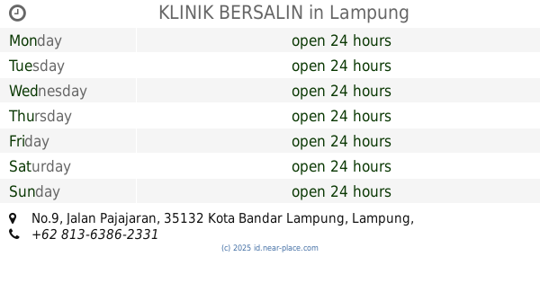
KLINIK BERSALIN
Jalan Pajajaran No.9, Jagabaya II
Pharmacy
read more
419 m
apotik santosa
Jalan Gajah No.17, Sidodadi
Pharmacy
read more
543 m
Apotik Jagabaya
Jalan Pajajaran No.10, Jagabaya II
Pharmacy
read more
579 m
Sidomari
Jalan Sri Kresna No.48, Sawah Brebes
Pharmacy
read more
631 m
Apotek Sehat
Jalan Teuku Umar No.44, Sidodadi
Pharmacy
read more
749 m
Kedaton Farma. PT
JL. Teuku Umar, No. 73, Kedaton, Sidodadi
Pharmacy
read more
817 m
Bithania
Jalan Teuku Umar No.34 C, Surabaya
Pharmacy
read more
830 m
arshop
Jagabaya II
Pharmacy
read more
830 m
century healtcare bandarlampung
Jagabaya II
Pharmacy
read more
830 m
Di Meja Kerja
Jagabaya II
Pharmacy
read more
844 m
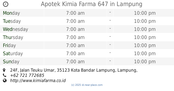
Apotek Kimia Farma 647
Jalan Teuku Umar No.24F, Sidodadi
Pharmacy
read more
870 m
Apotek Pertiwi
Jalan Teuku Umar No.48, Surabaya
Pharmacy
read more
887 m
Apotek Assipa
Pasir Gintung
Pharmacy
read more
895 m
Assiya Apotik
Jalan Imam Bonjol No.58, Pasir Gintung
Pharmacy
read more
900 m
Afifah
Gunung Sari
Pharmacy
read more
970 m
Timor Toko
JL. Sibolga, Blok B2, No. 24, Gunung Sari
Pharmacy
read more
979 m
Apotek Ananda Farma
JL Sibolga, No. 29 Blok A, Tanjung Karang, Gunung Sari
Pharmacy
read more
996 m
Anda Farma
Jalan Sibolga Blok A No.29, Gunung Sari
Pharmacy
read more
1.007 km
Raisha Medica
Jalan Teuku Umar No.48, Surabaya
Pharmacy
read more
1.133 km
Pajajaran
Jalan Pajajaran No.127, Jagabaya II
Pharmacy
read more
📑
all categories
Accounting
Administrative area level 1
Administrative area level 2
Airport
Amusement park
Aquarium
Art gallery
Atm
Bakery
Bank
Bar
Beauty salon
Bicycle store
Book store
Bowling alley
Bus station
Cafe
Campground
Car dealer
Car rental
Car repair
Car wash
Casino
Cemetery
Church
City hall
Clothing store
Colloquial area
Convenience store
Courthouse
Dentist
Department store
Doctor
Electrician
Electronics store
Embassy
Finance
Fire station
Florist
Food
Funeral home
Furniture store
Gas station
General contractor
Grocery or supermarket
Gym
Hair care
Hardware store
Health
Hindu Temple
Home goods store
Hospital
Insurance agency
Intersection
Jewelry store
Laundry
Lawyer
Library
Liquor store
Local government office
Locality
Locksmith
Lodging
Meal delivery
Meal takeaway
Mosque
Movie rental
Movie theater
Moving company
Museum
Natural feature
Neighborhood
Night club
Painter
Park
Parking
Pet store
Pharmacy
Physiotherapist
Place of worship
Plumber
Point of interest
Police
Political
Post office
Premise
Real estate agency
Restaurant
Roofing contractor
Route
Rv park, camping
School
Shoe store
Shopping mall
Spa
Stadium
Storage
Store
Subpremise
Supermarket
Synagogue
Taxi stand
Train station
Transit station
Travel agency
University
Veterinary care
Zoo
administrative area level 3
administrative area level 4
administrative area level 5
sublocality level 1
↑