Park nearby YATIMPLAY PEKALONGAN
Indonesia
Park nearby YATIMPLAY PEKALONGAN
YATIMPLAY PEKALONGAN
Gang 19 No.19, Landungsari Indonesia
contacts phone
:
+62
Latitude:
-6.9047991
, Longitude:
109.6789394
read more
nearest Park
484 m
Omah Sinau SOGAN
Gang 3, Kuripan Lor
Park
read more
548 m
Taman Kuripan Pekalongan "Nursery Horikultura
Jalan Hos Cokroaminoto, Kuripan Lor
Park
read more
771 m
Zona Aman
No., Jalan Raya Pantura No.102, Kebulen
Park
read more
1.598 km
Alun - Alun Kota Pekalongan
Jalan. Nusantara, Keputran
Park
read more
1.915 km
Taman Binatur
Podosugih
Park
read more
1.926 km
Mataram Park
Podosugih
Park
read more
1.972 km
Hutan Kota
Jalan Mataram, Podosugih
Park
read more
1.99 km
Lapangan Sorogenen
Poncol, Pekalongan Timur, Poncol
Park
read more
2.011 km
Sorogenen Public Park
Jalan Seruni, Poncol
Park
read more
2.165 km
Tugu Bambu Runcing
Bar., Bendan
Park
read more
2.177 km
Taman Bunga Wilis Pekalongan
Pringlangu
Park
read more
2.225 km
Taman Wilis Pekalongan
Podosugih
Park
read more
2.235 km
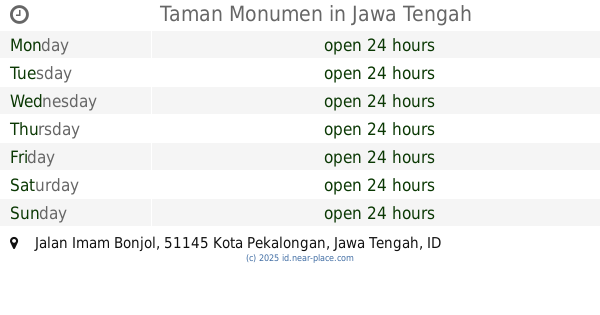
Taman Monumen
Jalan Imam Bonjol, Bendan
Park
read more
2.242 km
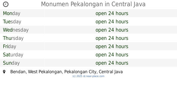
Monumen Pekalongan
Bendan
Park
read more
2.262 km
Stadion fc putra batik
Dekoro
Park
read more
2.437 km
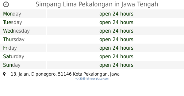
Simpang Lima Pekalongan
No., Jalan. Diponegoro No.13, Kergon
Park
read more
2.567 km
Taman Kecamatan Pekalongan Selatan
Kuripan Kidul
Park
read more
2.724 km
Bumimas Park
Klego Gg. 2b Rt. 09-Rw. 03 No. 30, Tim.,, Klego
Park
read more
2.754 km
Patiunus Garden
Jalan Pati Unus, Sugihwaras
Park
read more
2.761 km
Taman Jlamprang
Klego
Park
read more
2.911 km
Lapangan Jatayu
Panjang Wetan
Park
read more
2.939 km
Graha Tamansari
Jalan Angkatan 66, Kramatsari
Park
read more
2.952 km
Jatayu Cultural District
Jalan Jatayu, Kauman
Park
read more
2.965 km
Alun Alun Jatayu, Pekalongan
Panjang Wetan, Pekalongan Utara, Dukuh
Park
read more
3.591 km
Kendang Mas Tenun & Batik
Jl. Jlamprang Krapyak Lor, depan Mahakam, Krapyak Lor
Park
read more
📑
all categories
Accounting
Administrative area level 1
Administrative area level 2
Airport
Amusement park
Aquarium
Art gallery
Atm
Bakery
Bank
Bar
Beauty salon
Bicycle store
Book store
Bowling alley
Bus station
Cafe
Campground
Car dealer
Car rental
Car repair
Car wash
Casino
Cemetery
Church
City hall
Clothing store
Colloquial area
Convenience store
Courthouse
Dentist
Department store
Doctor
Electrician
Electronics store
Embassy
Finance
Fire station
Florist
Food
Funeral home
Furniture store
Gas station
General contractor
Grocery or supermarket
Gym
Hair care
Hardware store
Health
Hindu Temple
Home goods store
Hospital
Insurance agency
Intersection
Jewelry store
Laundry
Lawyer
Library
Liquor store
Local government office
Locality
Locksmith
Lodging
Meal delivery
Meal takeaway
Mosque
Movie rental
Movie theater
Moving company
Museum
Natural feature
Neighborhood
Night club
Painter
Park
Parking
Pet store
Pharmacy
Physiotherapist
Place of worship
Plumber
Point of interest
Police
Political
Post office
Premise
Real estate agency
Restaurant
Roofing contractor
Route
Rv park, camping
School
Shoe store
Shopping mall
Spa
Stadium
Storage
Store
Subpremise
Supermarket
Synagogue
Taxi stand
Train station
Transit station
Travel agency
University
Veterinary care
Zoo
administrative area level 3
administrative area level 4
administrative area level 5
sublocality level 1
↑