Park nearby Taman Kota Mareleng
Indonesia
Park nearby Taman Kota Mareleng
Taman Kota Mareleng
Bojongsari Indonesia
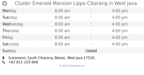
contacts phone
:
+62
Latitude:
-6.2678154
, Longitude:
107.2524579
read more
nearest Park
530 m
Taman Kota Pacing
Jalan Raya Rengas-Lemahabang, Waringinjaya
Park
read more
2.292 km
Lapangan Perum KDW
Jalan Raya Pebayuran, Kedungwaringin
Park
read more
2.975 km
REHAN CELL
Tunggakjati
Park
read more
3.087 km
Balong Bah Ewon Tunggak Jati
Jalan Raya Rengasdengklok, No.55, Karawang Barat, Tanjungmekar
Park
read more
3.695 km
CV. SARANA HUTAMA
Perumahan Karawang Festivalle Blok Q No, 2, Purwadana
Park
read more
5.134 km
Central Park, Grand Taruma
Sukamakmur
Park
read more
5.603 km
Tugu Padi Karawang
Jalan Kertabumi No.2, Karawang Kulon
Park
read more
5.657 km
Taman Kota Gonggo
Karawang Kulon
Park
read more
5.713 km
Taman Kota
No., Jalan Arif Rahman Hakim No.123, Karawang Kulon
Park
read more
6.502 km
Town Square Karawang
Jalan Tuparev, Nagasari
Park
read more
6.517 km
Alun-alun Karawang
Karawang Kulon, Karawang Barat, Karawang Kulon
Park
read more
7.368 km
Taman ARJUNA
Jalan Arjuna 10, Waluya
Park
read more
7.451 km
Air Mancur Taman Kota
Nagasari
Park
read more
8.282 km
Taman Ibu
Jalan Parahyangan No.46, Adiarsa Barat
Park
read more
9.446 km
Taman Peruri DOSKI
Telukjambe
Park
read more
11.008 km
Kost Tedi Wijaya
Pasirgombong
Park
read more
11.279 km
sukaraya regensi
Sukaraya
Park
read more
11.977 km
Lapangan Sepak Bola Buni Asih
Blok V No., Jalan Jababeka IV-E Blok V No.82, Karangbaru
Park
read more
12.383 km
Pos Blok H Gpp
Sukajaya
Park
read more
12.39 km
pos security blok O
Perumahan Gramapuri persada, Sukajaya
Park
read more
12.411 km
Pos Blok K GPP
Unnamed Road,, Sukajaya
Park
read more
13.16 km
Forest Green Lippo Cikarang
Jalan Gunung Batur No.17, Cibatu
Park
read more
14.024 km
Kefir Kitchen
Cibatu
Park
read more
14.326 km
Taman Bukit Marwa
Jalan Perum Telaga Sakinah, Telagamurni
Park
read more
14.375 km
Cluster Emerald Mansion Lippo Cikarang
Sukaresmi
Park
read more
📑
all categories
Accounting
Administrative area level 1
Administrative area level 2
Airport
Amusement park
Aquarium
Art gallery
Atm
Bakery
Bank
Bar
Beauty salon
Bicycle store
Book store
Bowling alley
Bus station
Cafe
Campground
Car dealer
Car rental
Car repair
Car wash
Casino
Cemetery
Church
City hall
Clothing store
Colloquial area
Convenience store
Courthouse
Dentist
Department store
Doctor
Electrician
Electronics store
Embassy
Finance
Fire station
Florist
Food
Funeral home
Furniture store
Gas station
General contractor
Grocery or supermarket
Gym
Hair care
Hardware store
Health
Hindu Temple
Home goods store
Hospital
Insurance agency
Intersection
Jewelry store
Laundry
Lawyer
Library
Liquor store
Local government office
Locality
Locksmith
Lodging
Meal delivery
Meal takeaway
Mosque
Movie rental
Movie theater
Moving company
Museum
Natural feature
Neighborhood
Night club
Painter
Park
Parking
Pet store
Pharmacy
Physiotherapist
Place of worship
Plumber
Point of interest
Police
Political
Post office
Premise
Real estate agency
Restaurant
Roofing contractor
Route
Rv park, camping
School
Shoe store
Shopping mall
Spa
Stadium
Storage
Store
Subpremise
Supermarket
Synagogue
Taxi stand
Train station
Transit station
Travel agency
University
Veterinary care
Zoo
administrative area level 3
administrative area level 4
administrative area level 5
sublocality level 1
↑