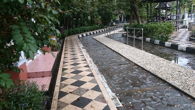
Park nearby Kawasan Hutan Kota
Indonesia
Park nearby Kawasan Hutan Kota
Kawasan Hutan Kota
Jalan Yos Sudarso, Prapatan Indonesia
contacts phone
:
+62
Latitude:
-1.2708944
, Longitude:
116.8141673
read more
nearest Park
863 m
Taman Volker Dorb
Prapatan
Park
read more
1.753 km
Puspoyudo I Park
Jalan Wiluyo Puspoyudo, Klandasan Ulu
Park
read more
1.783 km
Parks Wiluyo Puspo Yudho
Jalan Wiluyo Puspoyudo, Klandasan Ulu
Park
read more
1.798 km
Taman Wiloejo Poespojoedo
Jalan Wiluyo Puspoyudo, Klandasan Ulu
Park
read more
2.289 km
Taman Bekapai
Jalan Jenderal Sudirman, Klandasan Ulu, Balikpapan Kota, Klandasan Ulu
Park
read more
3.33 km
Taman Adipura
Jalan Pangeran Antasari, Karang Rejo
Park
read more
3.501 km
Tugu Peringatan Peristiwa Demonstrasi Rakyat Balikpapan
Mekar Sari
Park
read more
3.679 km
Hutan Mangrove
Marga Sari
Park
read more
3.839 km
X-Mac Fishing Workshop
Jalan Letjen S. Parman, Gunungsari Ulu
Park
read more
3.866 km
Depot Gunung Guntur Asri
Gunungsari Ulu, Balikpapan Tengah, Gunungsari Ulu
Park
read more
4.211 km
Toko Hasbi Plaza Kebun Sayur
Jalan Letjen Suprapto No.1, Marga Sari, Balikpapan Bar., Kota Balikpapan, Kalimantan Timur 76131, Marga Sari
Park
read more
4.353 km
Terminal Angkutan Kota - Kelurahan Baru Tengah
Jalan 21 Januari, Baru Tengah
Park
read more
4.664 km
Merpati YR Little Wing
Margo Mulyo
Park
read more
5.027 km
Mangrove Margo Mulyo
Jalan AMD Gunung Empat RT 42, Margomulyo, Balikpapan, Margo Mulyo
Park
read more
5.07 km
Kawasan Konservasi Mangrove Margomulyo
Margo Mulyo
Park
read more
5.572 km
Lapangan Jumpi
Bar., Baru Ulu
Park
read more
5.661 km
Depo Air Berlian
Gunung Samarinda
Park
read more
5.98 km
Diajengfarm
Jl. MT haryono perum bukit tanjung RT 1 no 43, Damai
Park
read more
6.097 km
BHJ Catering Dormitory
Perum Wahana Y-153, Stal Kuda, Gunung Bahagia
Park
read more
6.11 km
Pos Yandu Rt 51
Gunung Samarinda
Park
read more
6.122 km
Orlando Park
Damai
Park
read more
6.744 km
CAMP SATRIA UNITED futsal
Tim., Gunung Samarinda
Park
read more
8.082 km
Bendali 4 Lapangan Tenis
Gunung Bahagia
Park
read more
9.814 km
Bendali 1 Balikpapan
Unnamed Rd, Sel., Provinsi Kalimantan Tim., Sepinggan
Park
read more
10.069 km
Baitul Jannah Yenny Afandi
Batu Ampar
Park
read more
📑
all categories
Accounting
Administrative area level 1
Administrative area level 2
Airport
Amusement park
Aquarium
Art gallery
Atm
Bakery
Bank
Bar
Beauty salon
Bicycle store
Book store
Bowling alley
Bus station
Cafe
Campground
Car dealer
Car rental
Car repair
Car wash
Casino
Cemetery
Church
City hall
Clothing store
Colloquial area
Convenience store
Courthouse
Dentist
Department store
Doctor
Electrician
Electronics store
Embassy
Finance
Fire station
Florist
Food
Funeral home
Furniture store
Gas station
General contractor
Grocery or supermarket
Gym
Hair care
Hardware store
Health
Hindu Temple
Home goods store
Hospital
Insurance agency
Intersection
Jewelry store
Laundry
Lawyer
Library
Liquor store
Local government office
Locality
Locksmith
Lodging
Meal delivery
Meal takeaway
Mosque
Movie rental
Movie theater
Moving company
Museum
Natural feature
Neighborhood
Night club
Painter
Park
Parking
Pet store
Pharmacy
Physiotherapist
Place of worship
Plumber
Point of interest
Police
Political
Post office
Premise
Real estate agency
Restaurant
Roofing contractor
Route
Rv park, camping
School
Shoe store
Shopping mall
Spa
Stadium
Storage
Store
Subpremise
Supermarket
Synagogue
Taxi stand
Train station
Transit station
Travel agency
University
Veterinary care
Zoo
administrative area level 3
administrative area level 4
administrative area level 5
sublocality level 1
↑