Natural feature nearby Gunung Kunyit
Indonesia
Natural feature nearby Gunung Kunyit
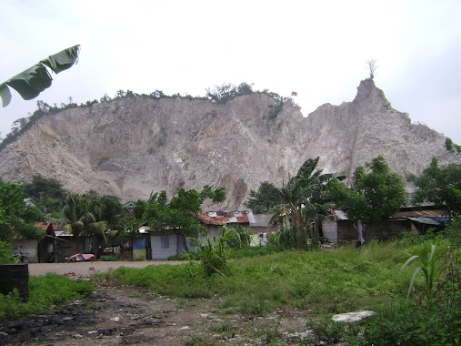
Gunung Kunyit
Gn. Kunyit, Bumi Waras, Kota Bandar Lampung, Lampung, Indonesia
contacts phone
:
+62
Latitude:
-5.4461111
, Longitude:
105.2797222
larger map & directions
read more
nearest Natural feature
2.385 km
Gunung Pahoman
Indonesia
Natural feature
read more
2.465 km
Basaran
Indonesia
Natural feature
read more
2.562 km
Pulau Pasaran
Indonesia
Natural feature
read more
4.342 km
Panjang
Indonesia
Natural feature
read more
4.383 km
Pamunggutan
Indonesia
Natural feature
read more
4.467 km
Gunung Balau
Indonesia
Natural feature
read more
4.551 km
DUTA Wisata
Jalan Laksamana R.E.Martadinata
Natural feature
read more
4.987 km
Teluk Lampung
Indonesia
Natural feature
read more
4.994 km
Cahaya Anugrah Rudevi. PT
JL. Kom. L. Yos Sudarso, No. 17/46, Panjang Utara, Panjang, Pidada
Natural feature
read more
5.192 km
Pulau Kubur
Indonesia
Natural feature
read more
5.495 km
Gunung Sahal
Indonesia
Natural feature
read more
5.569 km
Gunung Sigumur
Indonesia
Natural feature
read more
6.572 km
Pematang Segobak
Indonesia
Natural feature
read more
6.64 km
Bukit Bunut
Indonesia
Natural feature
read more
6.733 km
Pematang Tangkit
Indonesia
Natural feature
read more
7.058 km
Bukit Kedatuan
Indonesia
Natural feature
read more
7.379 km
Bukit Ranggal
Indonesia
Natural feature
read more
9.61 km
Tangkit Redok
Indonesia
Natural feature
read more
9.708 km
Pematang Kawat
Indonesia
Natural feature
read more
11.228 km
Pematang Wailimus
Indonesia
Natural feature
read more
📑
all categories
Accounting
Administrative area level 1
Administrative area level 2
Airport
Amusement park
Aquarium
Art gallery
Atm
Bakery
Bank
Bar
Beauty salon
Bicycle store
Book store
Bowling alley
Bus station
Cafe
Campground
Car dealer
Car rental
Car repair
Car wash
Casino
Cemetery
Church
City hall
Clothing store
Colloquial area
Convenience store
Courthouse
Dentist
Department store
Doctor
Electrician
Electronics store
Embassy
Finance
Fire station
Florist
Food
Funeral home
Furniture store
Gas station
General contractor
Grocery or supermarket
Gym
Hair care
Hardware store
Health
Hindu Temple
Home goods store
Hospital
Insurance agency
Intersection
Jewelry store
Laundry
Lawyer
Library
Liquor store
Local government office
Locality
Locksmith
Lodging
Meal delivery
Meal takeaway
Mosque
Movie rental
Movie theater
Moving company
Museum
Natural feature
Neighborhood
Night club
Painter
Park
Parking
Pet store
Pharmacy
Physiotherapist
Place of worship
Plumber
Point of interest
Police
Political
Post office
Premise
Real estate agency
Restaurant
Roofing contractor
Route
Rv park, camping
School
Shoe store
Shopping mall
Spa
Stadium
Storage
Store
Subpremise
Supermarket
Synagogue
Taxi stand
Train station
Transit station
Travel agency
University
Veterinary care
Zoo
administrative area level 3
administrative area level 4
administrative area level 5
sublocality level 1
↑