Mosque nearby Mushollah As-syafi'iyyah
Indonesia
Mosque nearby Mushollah As-syafi'iyyah
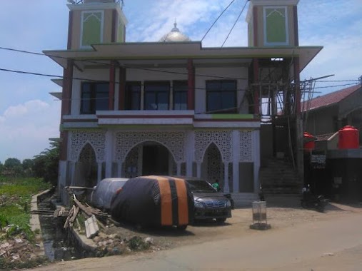
Mushollah As-syafi'iyyah
Jalan Raya Kosambi Timur No.14, Kosambi Timur Indonesia
contacts phone
:
+62
Latitude:
-6.0821636
, Longitude:
106.6928535
read more
nearest Mosque
138 m
Majelis Al-Yusuffiyah Kosambi
Jalan Raya Kosambi Timur No.17, Kosambi Timur
Mosque
read more
245 m
Musolah Nur Jannah
Cengklong
Mosque
read more
322 m
Masjid nurul Falah
Jalan Raya Kosambi Timur No.14, Kosambi Timur
Mosque
read more
446 m
Masjid Al-Fattah
No., Jalan Nurul Falah No.32, Kosambi Timur
Mosque
read more
783 m
Masjid Jami' Al Makmur.
West Kosambi
Mosque
read more
906 m
Masjid Jihadul Mukminin
Jalan Raya Kosambi Timur, Kosambi Timur
Mosque
read more
949 m
Musholla Nurul Iman
Dadap
Mosque
read more
956 m
Musola Nurul Iman
Cengklong
Mosque
read more
962 m
Mushola Baitul Muttaqin
East Kosambi
Mosque
read more
1.128 km
Masjid Baiturohman
Tim., Kosambi Timur
Mosque
read more
1.152 km
Masjid Jami Nurul Huda
Jalan Cengklong, Jatimulya
Mosque
read more
1.208 km
Musholla Al-Muhtaddiin
Jalan Jati Mulya No.6, RT.2/RW.3, Jatimulya
Mosque
read more
1.211 km
Jami Masjid Al-Hidayah
Jalan Raya Salembaran, Cengklong
Mosque
read more
1.227 km
Masjid Nurul Jannah
Cengklong
Mosque
read more
1.553 km
Masjid Jami An-nur
1 Kosambi Gg. Sahabat Kp.Talok, Jalan SMPN, Cengklong
Mosque
read more
1.708 km
Masjid Daaruth Thayyibah
Perumahan Duta Bandara Permai, Jatimulya, Kosambi, Jatimulya
Mosque
read more
1.83 km
Masjid At-Taqwa
Jalan Kebon Dua Ratus No.59, RT.5/RW.6, Kamal
Mosque
read more
1.912 km
Mushola Darusalam
Jl. Kp. Dadap Sawah RT.7 Dadap Tangerang Banten, Republik, Dadap
Mosque
read more
1.957 km
Masjid Al-Idrusiyah
Jalan Raya Perancis Blok Ff No.18, Dadap
Mosque
read more
1.982 km
Masjid Al Barkah
Desa Dadap, Kecamatan Kosambi, Dadap
Mosque
read more
2.009 km
Masjid Jami Baiturrohim
Belimbing
Mosque
read more
2.285 km
Mushola Nurul Iman
I, Sawah Mede No.23, RT.7/RW.6, Kamal
Mosque
read more
2.299 km
Masjid SDN Kamal
Jalan Kebon Dua Ratus RT.3/RW.6, Kamal
Mosque
read more
2.477 km
Masjid Hidayat Syakirin
Jalan Bakti Pramuka No.2, RT.10/RW.1, Kamal
Mosque
read more
2.504 km
MASJID LDII hidayatussyakiriin kebon kelapa
Blok Haji Amjani No.19A, Jalan Bakti Pramuka RT.10/RW.1, Kamal
Mosque
read more
📑
all categories
Accounting
Administrative area level 1
Administrative area level 2
Airport
Amusement park
Aquarium
Art gallery
Atm
Bakery
Bank
Bar
Beauty salon
Bicycle store
Book store
Bowling alley
Bus station
Cafe
Campground
Car dealer
Car rental
Car repair
Car wash
Casino
Cemetery
Church
City hall
Clothing store
Colloquial area
Convenience store
Courthouse
Dentist
Department store
Doctor
Electrician
Electronics store
Embassy
Finance
Fire station
Florist
Food
Funeral home
Furniture store
Gas station
General contractor
Grocery or supermarket
Gym
Hair care
Hardware store
Health
Hindu Temple
Home goods store
Hospital
Insurance agency
Intersection
Jewelry store
Laundry
Lawyer
Library
Liquor store
Local government office
Locality
Locksmith
Lodging
Meal delivery
Meal takeaway
Mosque
Movie rental
Movie theater
Moving company
Museum
Natural feature
Neighborhood
Night club
Painter
Park
Parking
Pet store
Pharmacy
Physiotherapist
Place of worship
Plumber
Point of interest
Police
Political
Post office
Premise
Real estate agency
Restaurant
Roofing contractor
Route
Rv park, camping
School
Shoe store
Shopping mall
Spa
Stadium
Storage
Store
Subpremise
Supermarket
Synagogue
Taxi stand
Train station
Transit station
Travel agency
University
Veterinary care
Zoo
administrative area level 3
administrative area level 4
administrative area level 5
sublocality level 1
↑