Mosque nearby Musholah An Nur
Indonesia
Mosque nearby Musholah An Nur
Musholah An Nur
Cibogo, Cisauk, Tangerang, Banten 15344, Indonesia
contacts phone
:
+62
Latitude:
-6.3259835
, Longitude:
106.6479067
larger map & directions
read more
nearest Mosque
143 m
Mushola Miftahul Huda
Perum Green BSD Cibogo Permai, Cibogo
Mosque
read more
306 m
musholla al awwabin
Fasum, Cibogo
Mosque
read more
322 m
Masjid Jami Al Wustho
Kampung Kedokan, RT. 010 RW. 02, Desa Cibogo, Cisauk, Cibogo
Mosque
read more
322 m
Masjid Jamie Al-Wustho
Jalan Kampung Cibogo No.12, Cibogo
Mosque
read more
366 m
Mushola Nurul Iman
Cibogo
Mosque
read more
382 m
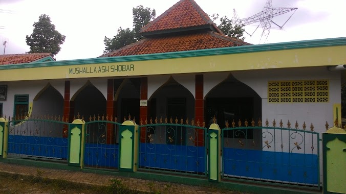
Mushalla Ash Shobar
No., Jalan Kampung Kedokan No.28, Cibogo
Mosque
read more
477 m
Musolah Aljannah Cibelut
Jalan Kampung Cibelut No.001, RT.002, Cibogo
Mosque
read more
497 m
Mushola As-Salam
Jalan Grahapura, Cibogo
Mosque
read more
517 m
Masjid Perum Eko Mandiri
Cibogo
Mosque
read more
666 m
Masjid Ummu Anas
Cibogo
Mosque
read more
876 m
Ikatan Remaja Masjid Sabilal Muhtadin
Jalan Raya Cisauk - Lapan No.8, Sampora
Mosque
read more
889 m
Masjid Sabilal Muhtadin Ibmas
Jalan Raya Cisauk - Lapan No.5-10, Sampora
Mosque
read more
1.148 km
Musholla Nurul Jalal
Jalan Padat karya, Situ Gadung
Mosque
read more
1.263 km
Masjid Al Ukhuwah BSD
Gerbang Utama The Avani, BSD City, Jalan Raya Cisauk - Lapan
Mosque
read more
1.263 km
Masjid Al Ukhuwah BSD
Gerbang Utama The Avani, BSD City, Jalan Raya Cisauk - Lapan, Sampora
Mosque
read more
1.348 km
Musholla Baitur Rohman
Jl. H. Madsyari, RT.02 / RW.01, Kranggan, Setu, Kranggan
Mosque
read more
1.452 km
Masjid Jami' Al-Ichlas
Jalan Kampung Cisauk Sinyal, Cisauk
Mosque
read more
1.515 km
Masjid Sabilun Najah
Sampora
Mosque
read more
1.593 km
Musholla Al Hikmah
kp koceak, Kranggan
Mosque
read more
1.689 km
Raudhatul Jannah Mosque
Kademangan
Mosque
read more
1.875 km
Masjid Mauzah Ali
Perumahan Citra Prima Serpong 1 Blok G No. 15, Muncul, Setu, Muncul
Mosque
read more
1.922 km
Masjid Al-Mabrur
No., Jalan Nn No.112, Serpong
Mosque
read more
1.973 km
Masjid Jami Nurul Huda Sampora
Jalan Alsintan No.44, Sampora
Mosque
read more
2.105 km
Masjid Jami' Al Latif Kademangan
Jalan Masjid Al Latif, Kademangan
Mosque
read more
2.11 km
Masjid Alatif
Jalan Kampung Kademangan, Kademangan
Mosque
read more
📑
all categories
Accounting
Administrative area level 1
Administrative area level 2
Airport
Amusement park
Aquarium
Art gallery
Atm
Bakery
Bank
Bar
Beauty salon
Bicycle store
Book store
Bowling alley
Bus station
Cafe
Campground
Car dealer
Car rental
Car repair
Car wash
Casino
Cemetery
Church
City hall
Clothing store
Colloquial area
Convenience store
Courthouse
Dentist
Department store
Doctor
Electrician
Electronics store
Embassy
Finance
Fire station
Florist
Food
Funeral home
Furniture store
Gas station
General contractor
Grocery or supermarket
Gym
Hair care
Hardware store
Health
Hindu Temple
Home goods store
Hospital
Insurance agency
Intersection
Jewelry store
Laundry
Lawyer
Library
Liquor store
Local government office
Locality
Locksmith
Lodging
Meal delivery
Meal takeaway
Mosque
Movie rental
Movie theater
Moving company
Museum
Natural feature
Neighborhood
Night club
Painter
Park
Parking
Pet store
Pharmacy
Physiotherapist
Place of worship
Plumber
Point of interest
Police
Political
Post office
Premise
Real estate agency
Restaurant
Roofing contractor
Route
Rv park, camping
School
Shoe store
Shopping mall
Spa
Stadium
Storage
Store
Subpremise
Supermarket
Synagogue
Taxi stand
Train station
Transit station
Travel agency
University
Veterinary care
Zoo
administrative area level 3
administrative area level 4
administrative area level 5
sublocality level 1
↑