Mosque nearby Mushola Nurul Iman Sumur Setapak
Indonesia
Mosque nearby Mushola Nurul Iman Sumur Setapak
Mushola Nurul Iman Sumur Setapak
Pakojan Indonesia
contacts phone
:
+62
Latitude:
-6.2111175
, Longitude:
106.6519693
read more
nearest Mosque
328 m
Musola Al Bahari
Jalan Hr. Rasuna Said No.17, Pakojan
Mosque
read more
427 m
Masjid Pakojan
Pakojan, Pinang, Pakojan
Mosque
read more
427 m
Mushollah Nurul Iman
Pakojan
Mosque
read more
432 m
Masjid Al Mubarok
Pakojan, Rt. 02 Rw. 04, Pinang, Pakojan
Mosque
read more
435 m
Masjid Nurul Haq
Pakojan, Rt. 02 Rw. 02, Pinang, Pakojan
Mosque
read more
436 m
Masjid Torikul Jannah
Pakojan, RT. 02 RW. 04, Pinang, Pakojan
Mosque
read more
581 m
Masjid Thariqul Jannah
Jalan Sultan Ageng Tirtayasa, Cipete
Mosque
read more
655 m
Masjid Al-Hidayah Sawah Dalam Tangerang
Jalan H. Aba, Panunggangan Utara
Mosque
read more
664 m
Nuurul Haq Mosque
Jalan Hr. Rasuna Said, Pakojan
Mosque
read more
681 m
Masjid Al Iklas
Cikokol
Mosque
read more
740 m
Musholla Jannatunaim
Jalan Sultan Ageng Tirtayasa, Pakojan
Mosque
read more
818 m
Masjid Al Quraisy Cipete
Jalan Hr. Rasuna Said, Cipete
Mosque
read more
859 m
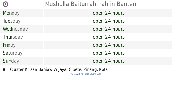
Musholla Baiturrahmah
Cluster Krisan Banjaw Wijaya, Cipete
Mosque
read more
869 m
Musholla Abu Bakar
Jalan Sultan Ageng Tirtayasa, Cipete
Mosque
read more
979 m
Masjid Darussa'adah
Jalan Gajah Mada, Cipete
Mosque
read more
1.012 km
Yayasan AR Rohman
Jl KH Akhmad Dahlan 17 RT 005%2F02 Ketapang Cipondoh Tangerang Banten, Kelapa Indah
Mosque
read more
1.117 km
Musholla Baitussalam - Cluster Grassia
Blok, Jalan Palem Puniks Blok B39 No.22, Cipete
Mosque
read more
1.169 km
Masjid Jami Darul
Komplek Cipondoh Makmur Blok E-5 RT 007 RW 05 Cipondoh Cipondoh Tangerang Banten, Kelapa Indah
Mosque
read more
1.238 km
Masjid Cipete
Jalan H.Risin Blok L2 No.1, RT.2/RW.9, Cipete
Mosque
read more
1.244 km
Masjid Al Ikhlash
Cipete, Rt. 01 Rw. 04, Pinang, Cipete
Mosque
read more
1.289 km
Kp Kunciran Gang Masjid Nurul Hikmah
no, Jalan Haji Rasuna Said Blok Gajah Mada No.10, RT.2/RW.2, Pakojan
Mosque
read more
1.317 km
Masjid LDII Annafiun
Jalan Kampung Sawah Dalam, Panunggangan Utara
Mosque
read more
1.317 km
Masjid LDII Annafiun
Tangerang, Jalan Kampung Sawah Dalam rt07 rw 04, Panunggangan Utara
Mosque
read more
1.407 km
Masjid Al Muhajirin
Komplek Pinang, RT. 02 RW. 06, Cipete
Mosque
read more
2.133 km
Mushola al'hikmah
Buaran Indah
Mosque
read more
📑
all categories
Accounting
Administrative area level 1
Administrative area level 2
Airport
Amusement park
Aquarium
Art gallery
Atm
Bakery
Bank
Bar
Beauty salon
Bicycle store
Book store
Bowling alley
Bus station
Cafe
Campground
Car dealer
Car rental
Car repair
Car wash
Casino
Cemetery
Church
City hall
Clothing store
Colloquial area
Convenience store
Courthouse
Dentist
Department store
Doctor
Electrician
Electronics store
Embassy
Finance
Fire station
Florist
Food
Funeral home
Furniture store
Gas station
General contractor
Grocery or supermarket
Gym
Hair care
Hardware store
Health
Hindu Temple
Home goods store
Hospital
Insurance agency
Intersection
Jewelry store
Laundry
Lawyer
Library
Liquor store
Local government office
Locality
Locksmith
Lodging
Meal delivery
Meal takeaway
Mosque
Movie rental
Movie theater
Moving company
Museum
Natural feature
Neighborhood
Night club
Painter
Park
Parking
Pet store
Pharmacy
Physiotherapist
Place of worship
Plumber
Point of interest
Police
Political
Post office
Premise
Real estate agency
Restaurant
Roofing contractor
Route
Rv park, camping
School
Shoe store
Shopping mall
Spa
Stadium
Storage
Store
Subpremise
Supermarket
Synagogue
Taxi stand
Train station
Transit station
Travel agency
University
Veterinary care
Zoo
administrative area level 3
administrative area level 4
administrative area level 5
sublocality level 1
↑