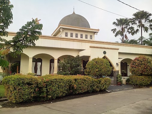
Mosque nearby Mushola Al Hidayah
Indonesia
Mosque nearby Mushola Al Hidayah
Mushola Al Hidayah
Jalan Raya Tapos, Cimpaeun Indonesien
contacts phone
:
+62
Latitude:
-6.4505155
, Longitude:
106.8649604
read more
nearest Mosque
58 m
Masjid Jami Al Asi
Jalan Raya Tapos, Cimpaeun
Mosque
read more
64 m
Kantor Sekretariat Masjid Al Asi
Jalan Raya Tapos, Cimpaeun
Mosque
read more
138 m
Masjid Al-Muhajirin
Jalan Tapos No.41, RT.2/RW.5, Cimpaeun
Mosque
read more
138 m
Masjid Al-Asyah
Jalan Tapos No.41, RT.2/RW.5, Cimpaeun
Mosque
read more
149 m
Masjid Al-Muawanah
Ciriung, RT. 04 RW. 01, Cimpaeun
Mosque
read more
239 m
Mushola Al Barokah
Jalan Raya Tapos RT.02/RW.-8, Cimpaeun
Mosque
read more
307 m
Masjid DARUL JANNAH
Perumahan Persada Depok,, Cimpaeun
Mosque
read more
370 m
Masjid Jami Nuruttaqwa
Jalan Tapos RT.05/RW.05, Cimpaeun
Mosque
read more
530 m
Mesjid Jami' Ar Rohman
Jalan Raya Tapos RT.01/RW.07, Cimpaeun
Mosque
read more
601 m
Masjid Roudhatul Muhajirin
Jalan Raya Tapos No.13, RT.1/RW.7, Cimpaeun
Mosque
read more
601 m
Masjid Hamidatul Mujahid
Jalan Raya Tapos No.1, RT.1/RW.7, Cilangkap
Mosque
read more
601 m
Masjid Zainul Rohman
Jalan Raya Tapos No.1, RT.1/RW.7, Cilangkap
Mosque
read more
620 m
Masjid Jami Nurul Iman
Cimpaeun
Mosque
read more
738 m
Masjid Jami' Nur Hasanah
Cimpaeun
Mosque
read more
749 m
Masjid Al Kautsar
Jalan Griya Telaga Permai, Cilangkap
Mosque
read more
773 m
masjid jami nur hasanah
Jalan Raya Cibinong Tapos Kampung Cimpaeun, Cimpaeun
Mosque
read more
836 m
Masjid Al Falah
Jalan Cilangkap, Cilangkap
Mosque
read more
841 m
Assadiyah
kp,nyencle.rt05, RW.01, Cilangkap
Mosque
read more
910 m
musholla Ash-shohabah
Cilangkap
Mosque
read more
923 m
Masjid Jamie Nurul Huda
Jalan Tapos Raya, Gang Hj. Alwi No.88, Cimpaeun, Tapos, Cimpaeun
Mosque
read more
1.078 km
Masjid Al-Ittihad, Permata Cimanggis
Jl. Boulevard Utama, Permata Cimanggis, Cimpaeun, Tapos, Cimpaeun
Mosque
read more
1.125 km
Masjid Nurul Falah
JL. Tapos, Rt. 44/06, Cijeruk, Ciriung
Mosque
read more
1.155 km
Masjid Attawwabiin
Jalan Cilangkap No.8, Cilangkap
Mosque
read more
1.232 km
Masjid Awaliyah
Jalan Raya Bogor / Kampung Kranji Blok Central No.3, Ciriung
Mosque
read more
1.246 km
Masjid Jami Arrohah
Ciriung
Mosque
read more
📑
all categories
Accounting
Administrative area level 1
Administrative area level 2
Airport
Amusement park
Aquarium
Art gallery
Atm
Bakery
Bank
Bar
Beauty salon
Bicycle store
Book store
Bowling alley
Bus station
Cafe
Campground
Car dealer
Car rental
Car repair
Car wash
Casino
Cemetery
Church
City hall
Clothing store
Colloquial area
Convenience store
Courthouse
Dentist
Department store
Doctor
Electrician
Electronics store
Embassy
Finance
Fire station
Florist
Food
Funeral home
Furniture store
Gas station
General contractor
Grocery or supermarket
Gym
Hair care
Hardware store
Health
Hindu Temple
Home goods store
Hospital
Insurance agency
Intersection
Jewelry store
Laundry
Lawyer
Library
Liquor store
Local government office
Locality
Locksmith
Lodging
Meal delivery
Meal takeaway
Mosque
Movie rental
Movie theater
Moving company
Museum
Natural feature
Neighborhood
Night club
Painter
Park
Parking
Pet store
Pharmacy
Physiotherapist
Place of worship
Plumber
Point of interest
Police
Political
Post office
Premise
Real estate agency
Restaurant
Roofing contractor
Route
Rv park, camping
School
Shoe store
Shopping mall
Spa
Stadium
Storage
Store
Subpremise
Supermarket
Synagogue
Taxi stand
Train station
Transit station
Travel agency
University
Veterinary care
Zoo
administrative area level 3
administrative area level 4
administrative area level 5
sublocality level 1
↑