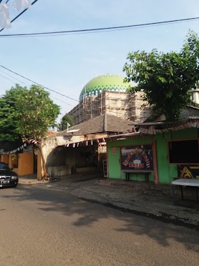
Mosque nearby Masjid Yamp - Makasar
Coronavirus disease (COVID-19) Situation
confirmed cases
6829221
deaths
162063
Indonesia
Mosque nearby Masjid Yamp - Makasar
Masjid Yamp - Makasar
82, Jalan Artileri, 13620, Kota Jakarta Timur, Daerah Khusus Ibukota Jakarta, ID Indonesia
contacts phone
:
+62
Latitude:
-6.250422
, Longitude:
106.9156529
larger map & directions
read more
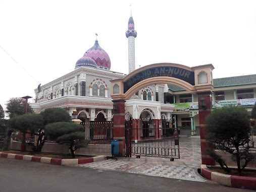
nearest Mosque
397 m
Masjid Agung Abadiah
Jl. Manunggal Raya 1 RT 011/RW 006, Kp. Curug, Cipinang melayu, Jaticempaka
Mosque
read more
431 m
Masjid Al-Aniyah
Kp. Jawa,, Cipinang Melayu
Mosque
read more
432 m
Masjid Jami Al-Maghfirah
Jalan Kompleks Dolog RT.3/RW.16, Duren Sawit
Mosque
read more
521 m
BC U1 X Malang
RT.3/RW.7, Cipinang Melayu
Mosque
read more
533 m
Mosque Riyadhus Righteous
Jl. Kav Agraria, RT.02/RW.16, Kel. Durensawit, RT.2/RW.16, Duren Sawit
Mosque
read more
591 m
Masjid Al Mujtaba Dahlan
Jalan Raden Inten II RT.2/RW.7, Duren Sawit
Mosque
read more
599 m
Masjid Jami Al Mujtaba
JL. H. Dahlan, RT. 02 RW. 07, Rawa Domba, Duren Sawit, RT.2/RW.7, Duren Sawit
Mosque
read more
600 m
Musholla Puri Sentra Niaga
RT.12/RW.7, Cipinang Melayu
Mosque
read more
776 m
Masjid An Nur
RT.8/RW.8, Pondok Kelapa
Mosque
read more
813 m
Mushollah Al-Mabrur
Jalan Ganesha No.20C, RT.1/RW.8, Pondok Kelapa
Mosque
read more
831 m
Masjid Al Huda
Kelapa Kopyor 10 Blok a3 No.5, RT.12/RW.7, Pondok Kelapa
Mosque
read more
869 m
Mushollah Al Misaniyah
Gang Swadaya XI, Jaticempaka
Mosque
read more
880 m
Musholla Al-Ihsan
Jalan Mushola Al-Ihsan No.13B, RT.6/RW.7, Duren Sawit
Mosque
read more
931 m
Masjid Al-Abraar
Jalan Anugrah Raya RW.8, Jaticempaka
Mosque
read more
954 m
Masjid Taman Duren Sawit
Jalan Kompleks Taman Duren Sawit RT.8/RW.16, Duren Sawit
Mosque
read more
974 m
Yayasan Masjid Jami Assa Adah
Jl. Pangkalan Jati VI No. 2 RT 015 RW 05 Cipinang Melayu Makasar Jakarta Timur DKI Jakarta, RT.7/RW.13, Cipinang Melayu
Mosque
read more
992 m
Masjid Jami Ash Shomad
Jalan Swadaya Raya No.15, RT.5/RW.5, Duren Sawit
Mosque
read more
1000 m
Masjid An Nuur Permata Timur
Blok, Jalan Raya Permata Timur Blok L No.9, RT.8/RW.8, Pondok Kelapa
Mosque
read more
1.023 km
Mushola Al Misbah
Jalan Pangkalan Jati V RT.3/RW.5, Cipinang Melayu
Mosque
read more
1.043 km
Masjid Al-Wustho
Jalan Masjid Al-Wustho RT.17/RW.7, Pondok Bambu
Mosque
read more
1.091 km
Kantor Polisi Jatiwaringin
Jalan Raya Jatiwaringin No.4, Jaticempaka
Mosque
read more
1.099 km
Masjid Andi Soraya
Jalan SMP 135 RT.7/RW.7, Pondok Bambu
Mosque
read more
1.116 km
Mushola Al Basyariah
Jalan Haji Basyar 1 No.4, Jaticempaka
Mosque
read more
1.163 km
Masjid Baiturosidin Klp 2
Jalan Pangkalan Jati VII No.61, RT.3/RW.9, Cipinang Melayu
Mosque
read more
1.165 km
masjid LDII
Unnamed Road, RT.3/RW.9, Cipinang Melayu
Mosque
read more
📑
all categories
Accounting
Administrative area level 1
Administrative area level 2
Airport
Amusement park
Aquarium
Art gallery
Atm
Bakery
Bank
Bar
Beauty salon
Bicycle store
Book store
Bowling alley
Bus station
Cafe
Campground
Car dealer
Car rental
Car repair
Car wash
Casino
Cemetery
Church
City hall
Clothing store
Colloquial area
Convenience store
Courthouse
Dentist
Department store
Doctor
Electrician
Electronics store
Embassy
Finance
Fire station
Florist
Food
Funeral home
Furniture store
Gas station
General contractor
Grocery or supermarket
Gym
Hair care
Hardware store
Health
Hindu Temple
Home goods store
Hospital
Insurance agency
Intersection
Jewelry store
Laundry
Lawyer
Library
Liquor store
Local government office
Locality
Locksmith
Lodging
Meal delivery
Meal takeaway
Mosque
Movie rental
Movie theater
Moving company
Museum
Natural feature
Neighborhood
Night club
Painter
Park
Parking
Pet store
Pharmacy
Physiotherapist
Place of worship
Plumber
Point of interest
Police
Political
Post office
Premise
Real estate agency
Restaurant
Roofing contractor
Route
Rv park, camping
School
Shoe store
Shopping mall
Spa
Stadium
Storage
Store
Subpremise
Supermarket
Synagogue
Taxi stand
Train station
Transit station
Travel agency
University
Veterinary care
Zoo
administrative area level 3
administrative area level 4
administrative area level 5
sublocality level 1
↑