Mosque nearby Masjid Muhammadiyah
Indonesia
Mosque nearby Masjid Muhammadiyah
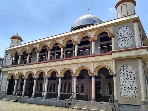
Masjid Muhammadiyah
JL Mayor Oking, Bogor, Gn. Putri, Bogor, Jawa Barat 16961, Indonesia
contacts phone
:
+62
Latitude:
-6.4673957
, Longitude:
106.8891559
larger map & directions
read more
nearest Mosque
238 m
Masjid Sabilul Jannah
Jalan Raya Gunung Putri No.10, Gunung Putri
Mosque
read more
274 m
Musholah Al-Hikmah
Jalan Kampung Gunung Putri No.34, Gunung Putri
Mosque
read more
301 m
Masjid Bogor Utara
Gunung Putri
Mosque
read more
306 m
Masjid LDII Baitul Kabir
Gunung Putri
Mosque
read more
311 m
Masjid Jami'Nurul Iman
Jalan Raya Gunung Putri, Gunung Putri
Mosque
read more
322 m
Masjid Nurul Iman Gunung Putri
Gang Mu'alim Asik Sulaeman, Gunung Putri
Mosque
read more
387 m
Masjid Al Ikhlas
16961, Jalan Sudi Mampir No.02/06, Cimanggis
Mosque
read more
409 m
Masjid Al Ikhlas
Jalan Raya Gunung Putri
Mosque
read more
543 m
Mushola Al Barokah
Gg mushola al barokah rt 03 rw 06 gunung putri, Kampung Parung Jambu, Gunung Putri
Mosque
read more
587 m
Masjid ASSA'ADAH
Puspanegara
Mosque
read more
620 m
Masjid As Salam Indocement
Cicadas
Mosque
read more
620 m
Masjid As Salam Indocement
Jalan Raya Bogasari No.5, Gunung Putri
Mosque
read more
637 m
Musholla Bojong Kidul
Puspanegara
Mosque
read more
639 m
Masjid As Salaam PT. Indocement Tunggal Prakarsa Tbk
Jalan Raya Bogasari, Citeureup
Mosque
read more
701 m
Masjid Al-hidayah
kp.blok mede rt 01/01, Jalan Raya Gunung Putri RT.3/RW.12, Gunung Putri
Mosque
read more
799 m
Mushola Al - Istiqomah
Citeureup
Mosque
read more
823 m
Musholah Al-Ibanah
Puspanegara
Mosque
read more
885 m
Mushola Pusaka
Klp., Bantar Jati
Mosque
read more
982 m
Mushola Al Barokah
Jalan Raya Gunung Putri, Bojong Nangka
Mosque
read more
988 m
As Salam Mosque
Jalan Kampung Gunung Putri No.45, Citeureup, Bogor, Jawa Barat 16810, Citeureup
Mosque
read more
1.001 km
Masjid Jamialhikmah
Jalan Gunung Putri Selatan No.3, Citeureup
Mosque
read more
1.023 km
Masjid Agung Al- Muqorrobin
Jalan Raya Gunung Putri, Gunung Putri
Mosque
read more
1.044 km
Masjid Jami Baiturrohim
Klp., Bantar Jati
Mosque
read more
1.116 km
Musholla ath-thoriq
Jalan Kampung Kamurang RT.01/RW.06, Puspasari
Mosque
read more
1.121 km
Musholla Al-Amiin
Jl Kp Puspa Negara No.10, Puspanegara
Mosque
read more
📑
all categories
Accounting
Administrative area level 1
Administrative area level 2
Airport
Amusement park
Aquarium
Art gallery
Atm
Bakery
Bank
Bar
Beauty salon
Bicycle store
Book store
Bowling alley
Bus station
Cafe
Campground
Car dealer
Car rental
Car repair
Car wash
Casino
Cemetery
Church
City hall
Clothing store
Colloquial area
Convenience store
Courthouse
Dentist
Department store
Doctor
Electrician
Electronics store
Embassy
Finance
Fire station
Florist
Food
Funeral home
Furniture store
Gas station
General contractor
Grocery or supermarket
Gym
Hair care
Hardware store
Health
Hindu Temple
Home goods store
Hospital
Insurance agency
Intersection
Jewelry store
Laundry
Lawyer
Library
Liquor store
Local government office
Locality
Locksmith
Lodging
Meal delivery
Meal takeaway
Mosque
Movie rental
Movie theater
Moving company
Museum
Natural feature
Neighborhood
Night club
Painter
Park
Parking
Pet store
Pharmacy
Physiotherapist
Place of worship
Plumber
Point of interest
Police
Political
Post office
Premise
Real estate agency
Restaurant
Roofing contractor
Route
Rv park, camping
School
Shoe store
Shopping mall
Spa
Stadium
Storage
Store
Subpremise
Supermarket
Synagogue
Taxi stand
Train station
Transit station
Travel agency
University
Veterinary care
Zoo
administrative area level 3
administrative area level 4
administrative area level 5
sublocality level 1
↑