Mosque nearby Masjid Monalissa
Indonesia
Mosque nearby Masjid Monalissa
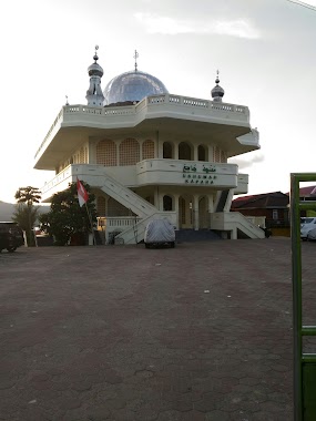
Masjid Monalissa
Jalan Monalisa, Kota Ambon, Maluku, ID Indonesia
contacts phone
:
+62
Latitude:
-3.6781033
, Longitude:
128.1918753
larger map & directions
read more
nearest Mosque
196 m
Masjid Al-Furqan
Batu Merah
Mosque
read more
246 m
Masjid Arema
Batu Merah
Mosque
read more
246 m
Masjid Tantui Atas
Batu Merah
Mosque
read more
252 m
Masjid AL-HIJRAH
Pandan Kasturi
Mosque
read more
327 m
Masjid Alim Pattimura
Teluk, Pandan Kasturi
Mosque
read more
354 m
Mesjid Mujiburahman
Batu Merah
Mosque
read more
383 m
Masjid Pandan Kasturi
Pandan Kasturi
Mosque
read more
389 m
Masjid Raya (Kapaha)
Jalan Sultan Hasanudin, Pandan Kasturi
Mosque
read more
577 m
Masjid Jabal Qubais (Tanjong Bawa)
Jalan Sultan Hasanudin, Batu Merah
Mosque
read more
594 m
Batu Merah Kepala Air
BMK, Batumerah
Mosque
read more
595 m
Masjid Tanjong Batu Merah
Batu Merah
Mosque
read more
614 m
Masjid Nurul Ikhlas Galunggung
Jalan Jenderal Sudirman, Galunggung, Batu Merah
Mosque
read more
705 m
Masjid Batu Merah Atas
Batu Merah
Mosque
read more
708 m
Masjid Al-Muhajirin
Batu Merah
Mosque
read more
742 m
Masjid ONGKO LIONG
Batu Merah
Mosque
read more
762 m
Sin Alauddin
Batu Merah
Mosque
read more
793 m
Abu Bakr Ash Shiddiq
Jalan Pergam, Batu Merah
Mosque
read more
827 m
Masjid Nurul Iman
KEPALA AIR, Batu Merah
Mosque
read more
854 m
Masjid Annur Tana Rata
Hative Kecil
Mosque
read more
922 m
Masjid Asrama Batumerah
Jalan Dokter Wem Tehupeiory, Kel Amantelu
Mosque
read more
927 m
Masjid Al-Ma'ruf (Bt. Merah)
Batu Merah
Mosque
read more
935 m
Mesjid Agung An-Nur Batu Merah
Batu Merah, Sirimau, Batu Merah
Mosque
read more
947 m
Mesjid Al Anshor
Jalan Pinang, Pasir Putih
Mosque
read more
1.016 km
masjid abu bakar ash shidiq
Jalan Kebun Cengkeh, Batu Merah, Sirimau, Batu Merah
Mosque
read more
1.22 km
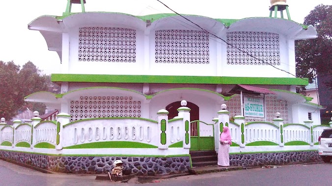
As'Syukur Mosque
Hative Kecil
Mosque
read more
📑
all categories
Accounting
Administrative area level 1
Administrative area level 2
Airport
Amusement park
Aquarium
Art gallery
Atm
Bakery
Bank
Bar
Beauty salon
Bicycle store
Book store
Bowling alley
Bus station
Cafe
Campground
Car dealer
Car rental
Car repair
Car wash
Casino
Cemetery
Church
City hall
Clothing store
Colloquial area
Convenience store
Courthouse
Dentist
Department store
Doctor
Electrician
Electronics store
Embassy
Finance
Fire station
Florist
Food
Funeral home
Furniture store
Gas station
General contractor
Grocery or supermarket
Gym
Hair care
Hardware store
Health
Hindu Temple
Home goods store
Hospital
Insurance agency
Intersection
Jewelry store
Laundry
Lawyer
Library
Liquor store
Local government office
Locality
Locksmith
Lodging
Meal delivery
Meal takeaway
Mosque
Movie rental
Movie theater
Moving company
Museum
Natural feature
Neighborhood
Night club
Painter
Park
Parking
Pet store
Pharmacy
Physiotherapist
Place of worship
Plumber
Point of interest
Police
Political
Post office
Premise
Real estate agency
Restaurant
Roofing contractor
Route
Rv park, camping
School
Shoe store
Shopping mall
Spa
Stadium
Storage
Store
Subpremise
Supermarket
Synagogue
Taxi stand
Train station
Transit station
Travel agency
University
Veterinary care
Zoo
administrative area level 3
administrative area level 4
administrative area level 5
sublocality level 1
↑