Mosque nearby Masjid Jami Nurul Haq
Indonesia
Mosque nearby Masjid Jami Nurul Haq
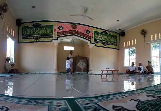
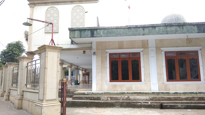
Masjid Jami Nurul Haq
Ragajaya, Bojong Gede, Bogor, West Java, Indonesia
contacts phone
:
+62
Latitude:
-6.4513323
, Longitude:
106.7842315
larger map & directions
read more
nearest Mosque
232 m
Musholla At-Taqwa
Ragajaya
Mosque
read more
300 m
musholla jabal rahmah
musholla jabal rahmah perumahan bukit pesanggrahan indah 1, Ragajaya
Mosque
read more
311 m
Mushola Mardhitillah
Jalan Tugu Macan No.59, Ragajaya
Mosque
read more
435 m
Musholla An-Nur Tamut
Ragajaya
Mosque
read more
512 m
Masjid Asmaurrahmah
Nanggerang
Mosque
read more
537 m
Mushalla Al-Faayyiz
Duren Baru Rt 02/06, Susukan
Mosque
read more
541 m
Masjid Al Amanah Bonecom
komplek bonecom.kp bambon rt 01rw07 ragajaya.bojonggede, Kampung Parung Jambu, Ragajaya
Mosque
read more
652 m
Mushola Al Ittihad
Jalan Duren Baru, Susukan
Mosque
read more
738 m
Mushalla Attaqwa
Jalan Puri Lestari 35 Blok 222 No.13, Pabuaran
Mosque
read more
745 m
Masjid Nurul Falah
JL. Kecubung Raya, RT. 03 RW. 12, Ragajaya, Bojong Gede, Ragajaya
Mosque
read more
752 m
Masjid Darul Mu'minin
Jalan Desa Bagajaya No.38, Ragajaya
Mosque
read more
778 m
masjid ataqwa
16920, Jalan Masjid At Taqwa, Susukan
Mosque
read more
796 m
Mushola Gemilang Citayam
Jalan Duren Baru No.58, Susukan
Mosque
read more
806 m
mushola al muhajirin
Susukan
Mosque
read more
869 m
Masjid Sendok
Jalan Tugu Macan No.59, Ragajaya
Mosque
read more
884 m
Masjid Sendok
Jalan Setapak No.11, Ragajaya
Mosque
read more
899 m
Masjid Kampung Sawah
No., Jalan Mushollah Al-Mukhtar No.86, Ragajaya
Mosque
read more
903 m
Jl. Masjid Annaja ( Sendok ) Citayam
Jalan Setapak No.45, RT.1/RW.2, Susukan
Mosque
read more
905 m
Masjid Al-Barkah
Depok, Jl. Kayu Manis 2, Pertanian, Bakti Jaya
Mosque
read more
943 m
Musholla Al Hidayah
Komp. Pegawai Dept. Pertanian Atsiri Permai, Jalan Widuri 4 No.20, Ragajaya
Mosque
read more
955 m
MASJID DUREN BARU PERMAI
Jalan Raya Pesona Citayam No.66, Susukan
Mosque
read more
961 m
Masjid Jami Al-Barkah
Jalan Dadap I No.17, Ragajaya
Mosque
read more
1.003 km
Masjid Jami Nurul Iman
Jalan Kampung Bulak, Nanggerang
Mosque
read more
1.143 km
Mushola Al-furqon
Jalan Kenanga III, Ragajaya
Mosque
read more
1.188 km
masjid Al ikhwan
Jalan Puri Lestari Raya, Pabuaran
Mosque
read more
📑
all categories
Accounting
Administrative area level 1
Administrative area level 2
Airport
Amusement park
Aquarium
Art gallery
Atm
Bakery
Bank
Bar
Beauty salon
Bicycle store
Book store
Bowling alley
Bus station
Cafe
Campground
Car dealer
Car rental
Car repair
Car wash
Casino
Cemetery
Church
City hall
Clothing store
Colloquial area
Convenience store
Courthouse
Dentist
Department store
Doctor
Electrician
Electronics store
Embassy
Finance
Fire station
Florist
Food
Funeral home
Furniture store
Gas station
General contractor
Grocery or supermarket
Gym
Hair care
Hardware store
Health
Hindu Temple
Home goods store
Hospital
Insurance agency
Intersection
Jewelry store
Laundry
Lawyer
Library
Liquor store
Local government office
Locality
Locksmith
Lodging
Meal delivery
Meal takeaway
Mosque
Movie rental
Movie theater
Moving company
Museum
Natural feature
Neighborhood
Night club
Painter
Park
Parking
Pet store
Pharmacy
Physiotherapist
Place of worship
Plumber
Point of interest
Police
Political
Post office
Premise
Real estate agency
Restaurant
Roofing contractor
Route
Rv park, camping
School
Shoe store
Shopping mall
Spa
Stadium
Storage
Store
Subpremise
Supermarket
Synagogue
Taxi stand
Train station
Transit station
Travel agency
University
Veterinary care
Zoo
administrative area level 3
administrative area level 4
administrative area level 5
sublocality level 1
↑