Mosque nearby Masjid Baiturrahman
Indonesia
Mosque nearby Masjid Baiturrahman
Masjid Baiturrahman
Ragemanunggal, Setu, Bekasi, West Java 17320, Indonezja
contacts phone
:
+62
Latitude:
-6.384927
, Longitude:
107.0142536
larger map & directions
read more
nearest Mosque
498 m
Musholla Ar Royyan OA
Ragemanunggal
Mosque
read more
652 m
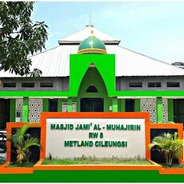
Masjid Al Muhajirin
Ragemanunggal
Mosque
read more
753 m
Masjid Al-Jaronah
Kp.Sadang Rt 01/01 Desa, Ragemanunggal
Mosque
read more
753 m
AL-JARONAH
Kp.Sadang Rt 01/01 Desa, Ragemanunggal
Mosque
read more
759 m
Masjid Radhwa Binti Salamah
Jalan Orchid Raya, Cikarageman
Mosque
read more
881 m
Musholla Al Himmatu
Perumahan Harvest City, Cluster Orchid Blok.H, Desa Cikarageman, Kecamatan Setu, Ragemanunggal
Mosque
read more
1.073 km
Masjid Smp Negeri 2 Setu, Bekasi
masjid smp negeri No.2, Cikarageman
Mosque
read more
1.109 km
Mushola An Nisa
perumahan griya pratama mas, Cikarageman
Mosque
read more
1.262 km
Baitul Rahman Mosque
Perumahan Griya Pratama Mas, Setu, Cikarageman
Mosque
read more
1.296 km
Musholla Al-Hikkam Metland Cileungsi
Jalan Metland Raya 3 No.9, Cipenjo
Mosque
read more
1.31 km
Masjid Al Hidayah
Harvest city, cluster orchid OE, Cikarageman
Mosque
read more
1.351 km
Musholla AL-FATTAH
Metland, Cipenjo, Cileungsi, Cipenjo
Mosque
read more
1.463 km
Masjid Abdullah Bin Mas'ud
Jalan Metland Raya 1, Cipenjo
Mosque
read more
1.47 km
Masjid Al Muhajirin RW 08 Metland Cileungsi
Jalan Metland Raya 3 No.8, Cipenjo
Mosque
read more
1.576 km
Masjid As Safir Cluster Edelweiss B
Cipenjo
Mosque
read more
1.589 km
Musholla Baitul Ma'mur, QB, Harvest City
Harvest City Quince Blossom
Mosque
read more
1.614 km
masjid jami' miftahul khoir
Jalan MT. Haryono No.53, Taman Rahayu
Mosque
read more
1.665 km
Mushola Babul Hidayah
jl MT. Haryono Kp Serang RT 01/03, Taman Rahayu
Mosque
read more
1.752 km
Masjid Al-Furqon (PLAN)
Rosemary, Blok RA, Harvest City, Cikarageman
Mosque
read more
1.779 km
Mushalla Al Furqon
Cipenjo
Mosque
read more
1.781 km
Majelis Raudhatul Muttalimin
Taman Rahayu
Mosque
read more
1.998 km
Musholla Al-Karomah
Taman Sari
Mosque
read more
2.113 km
Musola Almagfirah
Bekasi, Cikarageman
Mosque
read more
2.24 km
Masjid Sabilu Rohim
Cipenjo
Mosque
read more
2.28 km
Musolah Nurul Jannah
Taman Rahayu
Mosque
read more
📑
all categories
Accounting
Administrative area level 1
Administrative area level 2
Airport
Amusement park
Aquarium
Art gallery
Atm
Bakery
Bank
Bar
Beauty salon
Bicycle store
Book store
Bowling alley
Bus station
Cafe
Campground
Car dealer
Car rental
Car repair
Car wash
Casino
Cemetery
Church
City hall
Clothing store
Colloquial area
Convenience store
Courthouse
Dentist
Department store
Doctor
Electrician
Electronics store
Embassy
Finance
Fire station
Florist
Food
Funeral home
Furniture store
Gas station
General contractor
Grocery or supermarket
Gym
Hair care
Hardware store
Health
Hindu Temple
Home goods store
Hospital
Insurance agency
Intersection
Jewelry store
Laundry
Lawyer
Library
Liquor store
Local government office
Locality
Locksmith
Lodging
Meal delivery
Meal takeaway
Mosque
Movie rental
Movie theater
Moving company
Museum
Natural feature
Neighborhood
Night club
Painter
Park
Parking
Pet store
Pharmacy
Physiotherapist
Place of worship
Plumber
Point of interest
Police
Political
Post office
Premise
Real estate agency
Restaurant
Roofing contractor
Route
Rv park, camping
School
Shoe store
Shopping mall
Spa
Stadium
Storage
Store
Subpremise
Supermarket
Synagogue
Taxi stand
Train station
Transit station
Travel agency
University
Veterinary care
Zoo
administrative area level 3
administrative area level 4
administrative area level 5
sublocality level 1
↑