Mosque nearby Masjid Babul Jihad
Indonesia
Mosque nearby Masjid Babul Jihad
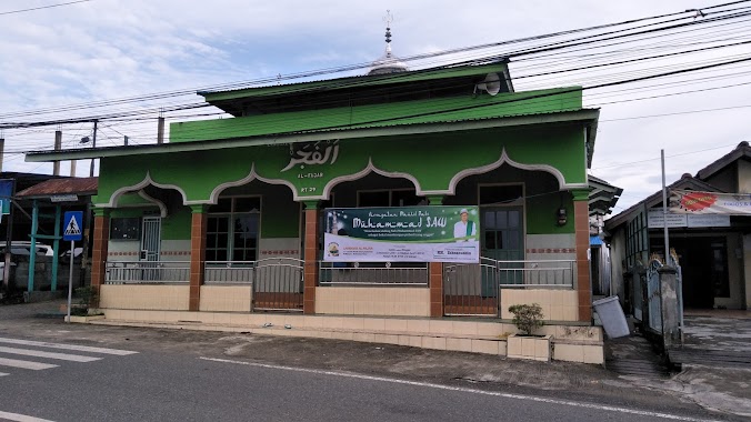
Masjid Babul Jihad
JL. Gunung Steling, Rt. 33 Rw. 34, Gunung Samarinda, Gunung Samarinda Indonesia
contacts phone
:
+62
Latitude:
-1.2305018
, Longitude:
116.8474009
read more
nearest Mosque
210 m
LANGGAR AL-MUKARRAMAH
Jalan Padat Karya, Gunung Samarinda
Mosque
read more
272 m
Masjid Qomarul Hidayah
Gunung Samarinda
Mosque
read more
405 m
Masjid Ar Rahman
JL. Gurinda III, Rt No.31, Gunung Samarinda
Mosque
read more
473 m
Masjid Jabal Nur
gn. stelling RT 52, Gunung Samarinda
Mosque
read more
488 m
Masjid Aljammi
Gunung Samarinda
Mosque
read more
499 m
Parkiran & TPA Masjid AL-AZIZ
Jalan Gunung Steling RT.52, Gunung Samarinda
Mosque
read more
511 m
Al Falaah Mosque
Jalan Gunung Samarinda, Gunung Samarinda
Mosque
read more
558 m
Masjid Al-Qomar
Jalan Soekarno Hatta No.6, Muara Rapak
Mosque
read more
573 m
Musholla Al Fatah
Gunung Samarinda
Mosque
read more
594 m
Masjid Al-Munawarroh
Gunung Samarinda
Mosque
read more
725 m
Musholla Sulubussalam
Gunung Samarinda
Mosque
read more
749 m
Masjid Ibrahim
Jalan Dua, Gunung Samarinda
Mosque
read more
755 m
Masjid Al-Amin
Jalan Soekarno Hatta, Batu Ampar
Mosque
read more
779 m
Masjid Ar Rahman
Gunung Samarinda
Mosque
read more
814 m
Langgar Al-Fajar
Jalan Indrakila No.71, Gunung Samarinda
Mosque
read more
865 m
Masjid Asy Syahid
Jalan Staart 1 No.Rt. 03, Gunung Samarinda
Mosque
read more
878 m
Mesjid Babusalam
D.I. RT. 08, Jalan Di Panjaitan, Gunung Samarinda
Mosque
read more
925 m
Mesjid Babusalam Baru
Jalan Satu, Gunung Samarinda
Mosque
read more
928 m
masjid assysyahid
Jalan Staart 1, Gunung Samarinda
Mosque
read more
949 m
Masjid As Syahid
Gunung Samarinda
Mosque
read more
950 m
Musholla Ash-Habul Yamin
Batu Ampar
Mosque
read more
961 m
Masjid Darussalam
Muara Rapak, Balikpapan Utara, Muara Rapak
Mosque
read more
965 m
Masjid Jami Darussalam
Jalan Soekarno Hatta, Muara Rapak
Mosque
read more
1.083 km
Masjid Babussalam
JL. Strat 1, Rt. 8, Gunung Samarinda, Gunung Samarinda
Mosque
read more
1.16 km
Masjid Nurul Khoir
JL. Projakal, Km. 5, 5, Balikpapan Utara, Muara Rapak
Mosque
read more
📑
all categories
Accounting
Administrative area level 1
Administrative area level 2
Airport
Amusement park
Aquarium
Art gallery
Atm
Bakery
Bank
Bar
Beauty salon
Bicycle store
Book store
Bowling alley
Bus station
Cafe
Campground
Car dealer
Car rental
Car repair
Car wash
Casino
Cemetery
Church
City hall
Clothing store
Colloquial area
Convenience store
Courthouse
Dentist
Department store
Doctor
Electrician
Electronics store
Embassy
Finance
Fire station
Florist
Food
Funeral home
Furniture store
Gas station
General contractor
Grocery or supermarket
Gym
Hair care
Hardware store
Health
Hindu Temple
Home goods store
Hospital
Insurance agency
Intersection
Jewelry store
Laundry
Lawyer
Library
Liquor store
Local government office
Locality
Locksmith
Lodging
Meal delivery
Meal takeaway
Mosque
Movie rental
Movie theater
Moving company
Museum
Natural feature
Neighborhood
Night club
Painter
Park
Parking
Pet store
Pharmacy
Physiotherapist
Place of worship
Plumber
Point of interest
Police
Political
Post office
Premise
Real estate agency
Restaurant
Roofing contractor
Route
Rv park, camping
School
Shoe store
Shopping mall
Spa
Stadium
Storage
Store
Subpremise
Supermarket
Synagogue
Taxi stand
Train station
Transit station
Travel agency
University
Veterinary care
Zoo
administrative area level 3
administrative area level 4
administrative area level 5
sublocality level 1
↑