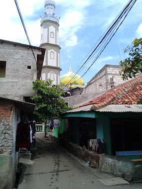
Mosque nearby Al-Istighfar
Indonesia
Mosque nearby Al-Istighfar
Al-Istighfar
Jalan Kayu Besar Dalam RT.13/RW.11, Cengkareng Timur Indonesien
contacts phone
:
+62
Latitude:
-6.1227276
, Longitude:
106.7316673
read more
nearest Mosque
95 m
Masjid "Al-Muzzammil" SMK 1 CITRA ADHI PRATAMA
12, RT.12/RW.11, Cengkareng Timur
Mosque
read more
236 m
Masjid Jami Nurul Qomar
Jalan Kayu Besar 1 RT. 003 RW. 012, Tegal Alur, Kalideres, RT.2/RW.12, Tegal Alur
Mosque
read more
350 m
Mesjid Jami AL Falah
Jalan Kayu Besar Dalam RT.10/RW.11, Cengkareng Timur
Mosque
read more
389 m
Jl Gang Masjid Nurul Qomar
Jalan Masjid Nurul Qomar No.18, RT.1/RW.12, Tegal Alur
Mosque
read more
392 m
Masjid Al Amanah
Jalan Tegal Alur RT.08/RW.10, Kalideres, RT.1/RW.12, Tegal Alur
Mosque
read more
392 m
Masjid Darul Ma`arif
Jalan Mesjid Nurul Kamal No.10, RT.1/RW.12, Tegal Alur
Mosque
read more
392 m
Masjid Nurul Komar
Jalan Mesjid Nurul Kamal No.10, RT.1/RW.12, Tegal Alur
Mosque
read more
392 m
Masjid Al Barkah
Jalan Mesjid Nurul Kamal No.10, RT.1/RW.12, Tegal Alur
Mosque
read more
392 m
Masjid Darurrahman
Jalan Mesjid Nurul Kamal No.10, RT.1/RW.12, Tegal Alur
Mosque
read more
421 m
Masjid Nurul Qomar
Jalan Masjid Nurul Qomar No.216, RT.3/RW.12, Tegal Alur
Mosque
read more
520 m
Masjid Baitul Karim
No., Jalan Kamal Muara No.87, RT.2/RW.2, Kamal Muara
Mosque
read more
564 m
Mushola Al-muhajirin
Jalan Kayu Besar Dalam No.69 Blok Demplon, Cengkareng, RT.7/RW.11, Cengkareng Timur
Mosque
read more
661 m
Masjid Nurul Amin
Blok Pojok 1, Jalan Kayu Besar Dalam Blok Pojok 1 No.22, RT.5/RW.11, Cengkareng Timur
Mosque
read more
702 m
Musollah Nur Fadillah
Jalan Kapuk Kamal No.90, RT.11/RW.12, Tegal Alur
Mosque
read more
881 m
Musholla Al Hikmah, Kapuk Rawa Gabus, Cengkareng
Blok Rawa Gabus, Jalan Kamal Raya Blok Rawa Gabus No.25, RT.7/RW.11, Kapuk
Mosque
read more
936 m
Masjid Ath-Tolibin
Jalan Kamal Raya No.26, RT.1/RW.6, Cengkareng Barat
Mosque
read more
977 m
Jami Baitul Amal
Jalan Raya Menceng RT.8/RW.9, Cengkareng Barat
Mosque
read more
987 m
Masjid Baitul A`mal
JL. Menceng, RT. 09/09, RT.8/RW.9, Cengkareng Barat
Mosque
read more
988 m
Masjid Al Anshor
RT.5/RW.14, Cengkareng Barat
Mosque
read more
1000 m
Mushola Annur
RT.13/RW.11, Kapuk
Mosque
read more
1.022 km
Masjid Rohmatul Muhajirin
JL. Flamboyan, RT. 14/10, Cengkareng, RT.1/RW.4, Cengkareng Barat
Mosque
read more
1.029 km
Masjid Jaami Al Istiqomah
Jalan Kamal Raya, RT.2/RW.8, Cengkareng Barat, Cengkareng, RT.2/RW.8, Cengkareng Barat
Mosque
read more
1.085 km
MASJID AL-MUHAJIRIN
RT.2/RW.10, Cengkareng Barat
Mosque
read more
1.166 km
Mushola Al Mujahidin
Jalan Kapuk Raya Blok Ampera No.20, RT.5/RW.11, Kapuk
Mosque
read more
1.256 km
Masjid Al-Huda
Jalan Kamal Muara RT. 004/RW. 01, RT.4/RW.8, Tegal Alur
Mosque
read more
📑
all categories
Accounting
Administrative area level 1
Administrative area level 2
Airport
Amusement park
Aquarium
Art gallery
Atm
Bakery
Bank
Bar
Beauty salon
Bicycle store
Book store
Bowling alley
Bus station
Cafe
Campground
Car dealer
Car rental
Car repair
Car wash
Casino
Cemetery
Church
City hall
Clothing store
Colloquial area
Convenience store
Courthouse
Dentist
Department store
Doctor
Electrician
Electronics store
Embassy
Finance
Fire station
Florist
Food
Funeral home
Furniture store
Gas station
General contractor
Grocery or supermarket
Gym
Hair care
Hardware store
Health
Hindu Temple
Home goods store
Hospital
Insurance agency
Intersection
Jewelry store
Laundry
Lawyer
Library
Liquor store
Local government office
Locality
Locksmith
Lodging
Meal delivery
Meal takeaway
Mosque
Movie rental
Movie theater
Moving company
Museum
Natural feature
Neighborhood
Night club
Painter
Park
Parking
Pet store
Pharmacy
Physiotherapist
Place of worship
Plumber
Point of interest
Police
Political
Post office
Premise
Real estate agency
Restaurant
Roofing contractor
Route
Rv park, camping
School
Shoe store
Shopping mall
Spa
Stadium
Storage
Store
Subpremise
Supermarket
Synagogue
Taxi stand
Train station
Transit station
Travel agency
University
Veterinary care
Zoo
administrative area level 3
administrative area level 4
administrative area level 5
sublocality level 1
↑