Lodging nearby Villa Samara
Indonesia
Lodging nearby Villa Samara
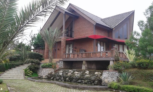
Villa Samara
28, Jalan Waru Doyong, 16750, Bogor, Jawa Barat, ID Indonesia
contacts phone
:
+62
Latitude:
-6.6835538
, Longitude:
106.910601
larger map & directions
read more
nearest Lodging
179 m
Villa Faijo
Jalan Waru Doyong No.41, Kuta
Lodging
read more
359 m
Pondok Salam Ressort
Jalan Kopo, Sukagalih
Lodging
read more
380 m
Pon Pes Tahfidz Quran Daarul Mughni Al Maaliki2 Megamendung
Jalan Megamendung - Ciawi, Kuta
Lodging
read more
543 m
Hotel Pullman Vimala hills agung Podomoro Group
Lodging
read more
553 m
SEDAP ALAMI
Jalan Cikopo Selatan, Sukagalih
Lodging
read more
573 m
Villa 88
Jl. Pasir Kalong No. 37, Megamendung, Sukagalih
Lodging
read more
588 m
Pelepah Pirang
Jalan Lembah Nendeut No.37, Sukagalih
Lodging
read more
599 m
Villa 1001
Jalan Waru Doyong No.45, Kuta
Lodging
read more
614 m
Griya Minna
Kopo
Lodging
read more
674 m
Saung Ikebana
Kuta
Lodging
read more
706 m
Villa Sopohasian
Kuta
Lodging
read more
706 m
Villa Bata Merah
No., Jalan Lembah Nendeut No.37, Sukagalih
Lodging
read more
732 m
Villa Keraton
Jalan Desa Kuta No 56, Cikopo, Sukamahi, Megamendung, Kuta
Lodging
read more
755 m
High Land Hotel
Jl. Babakan Kp. Gadog Tengah, Sukajadi
Lodging
read more
866 m
Vila Bumi Elok Resort
Sukagalih
Lodging
read more
877 m
Villa 27
Kopo
Lodging
read more
903 m
Bale Bengong
Jalan Cikopo Selatan, Sukakarya
Lodging
read more
907 m
Villa CB 383
Unnamed Rd,, Kuta
Lodging
read more
922 m
Cherokee Tent JSI
Sukagalih
Lodging
read more
975 m
Villa Lapang
Kopo
Lodging
read more
982 m
Villa Trimurti
Kopo
Lodging
read more
1.014 km
Villa Kelengkeng Alam Boriska
Jalan Raya Pasir Muncang No.2, Sukamanah
Lodging
read more
1.214 km
Villa Kopasus
Jl. WaruDoyong, Pekancilan, Kuta
Lodging
read more
1.245 km
Pondok Cidokom Indah
Kopo
Lodging
read more
1.294 km
JEEP STATION INDONESIA
Sukaresmi
Lodging
read more
📑
all categories
Accounting
Administrative area level 1
Administrative area level 2
Airport
Amusement park
Aquarium
Art gallery
Atm
Bakery
Bank
Bar
Beauty salon
Bicycle store
Book store
Bowling alley
Bus station
Cafe
Campground
Car dealer
Car rental
Car repair
Car wash
Casino
Cemetery
Church
City hall
Clothing store
Colloquial area
Convenience store
Courthouse
Dentist
Department store
Doctor
Electrician
Electronics store
Embassy
Finance
Fire station
Florist
Food
Funeral home
Furniture store
Gas station
General contractor
Grocery or supermarket
Gym
Hair care
Hardware store
Health
Hindu Temple
Home goods store
Hospital
Insurance agency
Intersection
Jewelry store
Laundry
Lawyer
Library
Liquor store
Local government office
Locality
Locksmith
Lodging
Meal delivery
Meal takeaway
Mosque
Movie rental
Movie theater
Moving company
Museum
Natural feature
Neighborhood
Night club
Painter
Park
Parking
Pet store
Pharmacy
Physiotherapist
Place of worship
Plumber
Point of interest
Police
Political
Post office
Premise
Real estate agency
Restaurant
Roofing contractor
Route
Rv park, camping
School
Shoe store
Shopping mall
Spa
Stadium
Storage
Store
Subpremise
Supermarket
Synagogue
Taxi stand
Train station
Transit station
Travel agency
University
Veterinary care
Zoo
administrative area level 3
administrative area level 4
administrative area level 5
sublocality level 1
↑