Lodging nearby Top View Penginapan Murah
Indonesia
Lodging nearby Top View Penginapan Murah
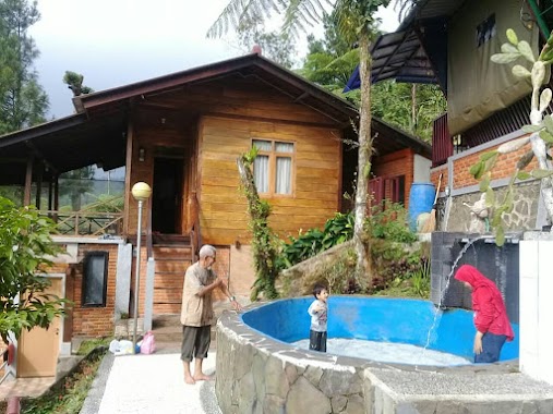
Top View Penginapan Murah
Jalan Gunung Picung, 16810, Bogor, Jawa Barat, ID Indonesia
contacts phone
:
+62 856-8281-708
Latitude:
-6.6987826
, Longitude:
106.6870181
larger map & directions
read more
nearest Lodging
75 m
Villa Lembah Pesona
Jalan Gunung Picung, Gunung Sari
Lodging
read more
119 m
Saung Lokapurna
Lokapurna Gn Salak Endah, Gunung Sari
Lodging
read more
190 m
Villa Kaka Cimudal
Jalan Curug Cigamea, Gunung Sari
Lodging
read more
234 m
Pondok Dr Idris Idham
Gunung Sari
Lodging
read more
236 m
Villa"DAHLIA"
Jl. Raya Salak Endah No. 17-18, Desa Gn. Sari, Pamijahan, Gunung Sari
Lodging
read more
240 m
Villanames2 Gunung Bunder
Jalan Curug Cigamea, Gunung Sari
Lodging
read more
260 m
Vila Betawi
Jalan Curug Cigamea, Gunung Sari
Lodging
read more
262 m
Gerbang Utama Panorama Alam
Gunung Sari
Lodging
read more
306 m
Saung Maranty ( kang Nchepz )
kp. rawa lega Rt. 02 rw 09 desa, Gunung Sari
Lodging
read more
397 m
Pondok Wisata Alam Nur Amir
Gunung Picung
Lodging
read more
458 m
Camping Graun
Air Terjun Cigamea, Jalan Curug Cigamea, Gunung Sari
Lodging
read more
482 m
Vila Dzikri
Gunung Sari
Lodging
read more
485 m
Villa Dinafizka
Jalan Gunung Picung, Gunung Sari
Lodging
read more
502 m
Villa November
Jalan Gunung Picung, Gunung Sari
Lodging
read more
531 m
Saung Benteng
Gunung Picung
Lodging
read more
577 m
Villa Jemaras Batu Gajah
Gunung Picung
Lodging
read more
700 m
Villa Pink
Jalan Gunung Picung, Gunung Sari
Lodging
read more
716 m
HARIS FAMILY CAMP
Gunung Picung
Lodging
read more
721 m
Poeti Mountain View Resort
Gunung Sari
Lodging
read more
789 m
Vila Pink
Jalan Gunung Bunder, Gunung Picung
Lodging
read more
1.046 km
Home Stay Deliza
Gunung Sari
Lodging
read more
1.069 km
Pondok 97
Jalan Gunung Picung, Gunung Sari
Lodging
read more
1.17 km
villa bima
Gunung Sari
Lodging
read more
1.17 km
pondok kalembo ade
Gunung Sari
Lodging
read more
1.334 km
Homestay Lariska
Gunung Sari
Lodging
read more
📑
all categories
Accounting
Administrative area level 1
Administrative area level 2
Airport
Amusement park
Aquarium
Art gallery
Atm
Bakery
Bank
Bar
Beauty salon
Bicycle store
Book store
Bowling alley
Bus station
Cafe
Campground
Car dealer
Car rental
Car repair
Car wash
Casino
Cemetery
Church
City hall
Clothing store
Colloquial area
Convenience store
Courthouse
Dentist
Department store
Doctor
Electrician
Electronics store
Embassy
Finance
Fire station
Florist
Food
Funeral home
Furniture store
Gas station
General contractor
Grocery or supermarket
Gym
Hair care
Hardware store
Health
Hindu Temple
Home goods store
Hospital
Insurance agency
Intersection
Jewelry store
Laundry
Lawyer
Library
Liquor store
Local government office
Locality
Locksmith
Lodging
Meal delivery
Meal takeaway
Mosque
Movie rental
Movie theater
Moving company
Museum
Natural feature
Neighborhood
Night club
Painter
Park
Parking
Pet store
Pharmacy
Physiotherapist
Place of worship
Plumber
Point of interest
Police
Political
Post office
Premise
Real estate agency
Restaurant
Roofing contractor
Route
Rv park, camping
School
Shoe store
Shopping mall
Spa
Stadium
Storage
Store
Subpremise
Supermarket
Synagogue
Taxi stand
Train station
Transit station
Travel agency
University
Veterinary care
Zoo
administrative area level 3
administrative area level 4
administrative area level 5
sublocality level 1
↑