Lodging nearby Outbound Murah
Indonesia
Lodging nearby Outbound Murah
Outbound Murah
Jalan Gunung Batu, 16810, Bogor, Jawa Barat, ID Indonesia
contacts phone
:
+62 812-8279-772
website:
www.outbound-murah.com
Latitude:
-6.6247534
, Longitude:
106.9062388
larger map & directions
read more
nearest Lodging
265 m
Mood Camp Resort
Bojong Koneng
Lodging
read more
291 m
Paradiso Hut
Bojong Koneng
Lodging
read more
356 m
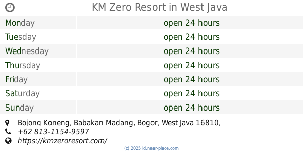
KM Zero Resort
Bojong Koneng
Lodging
read more
492 m
Villa K’Boen Que
Cijayanti
Lodging
read more
561 m
Richie The Farmer
Jl. Gunung Batu - Cijayanti, Desa Bojong Koneng, Babakan Madang, Sentul, Cijayanti
Lodging
read more
639 m
Villa Djawi
Unnamed Road, Cijayanti
Lodging
read more
709 m
Kana St. Valley Inn
Cijayanti
Lodging
read more
803 m
Lookman
Jalan Gunung Batu, Cijayanti
Lodging
read more
926 m
Pondok Pesantren Al-ikhlas Nuruttaqwa
Cijayanti
Lodging
read more
929 m
Kebon Hambalang
Bojong Koneng
Lodging
read more
982 m
Vila Ajun Winara Hs
Unnamed Road, Bojong Koneng
Lodging
read more
1.003 km
Vila 69
Jalan Sentul Paradise Park, Bojong Koneng
Lodging
read more
1.134 km
GnR Farm
Bojong Koneng
Lodging
read more
1.194 km
pemakaman Taman Tulang Bahagia
Unnamed Road, Bojong Koneng
Lodging
read more
1.23 km
Edensor Hills Villa, Resort & Cafe
Bojong Koneng
Lodging
read more
1.6 km
Toduri Villa
Megamendung
Lodging
read more
1.601 km
Villa Wien
Lodging
read more
1.661 km
Kampoeng Awan
Jalan Mega Mendung, Sirnagalih, Bogor Tengah, Megamendung
Lodging
read more
1.829 km
PT. Lima Sukses Utama
Cipayung Datar
Lodging
read more
1.898 km
Villa Bu Hasan
highland park, Megamendung
Lodging
read more
2.024 km
VILLA UMI ADE
Unnamed Road, Megamendung
Lodging
read more
2.091 km
villa om megin
Lodging
read more
2.103 km
Mega Indah Villa Estate
Jalan Perhutani, Megamendung
Lodging
read more
2.219 km
Villa Bergas Mega Indah
Jalan Raya Puncak Cipayung, Cipayung Girang
Lodging
read more
2.23 km
Lumbung Padi Resort
Cipayung Datar
Lodging
read more
📑
all categories
Accounting
Administrative area level 1
Administrative area level 2
Airport
Amusement park
Aquarium
Art gallery
Atm
Bakery
Bank
Bar
Beauty salon
Bicycle store
Book store
Bowling alley
Bus station
Cafe
Campground
Car dealer
Car rental
Car repair
Car wash
Casino
Cemetery
Church
City hall
Clothing store
Colloquial area
Convenience store
Courthouse
Dentist
Department store
Doctor
Electrician
Electronics store
Embassy
Finance
Fire station
Florist
Food
Funeral home
Furniture store
Gas station
General contractor
Grocery or supermarket
Gym
Hair care
Hardware store
Health
Hindu Temple
Home goods store
Hospital
Insurance agency
Intersection
Jewelry store
Laundry
Lawyer
Library
Liquor store
Local government office
Locality
Locksmith
Lodging
Meal delivery
Meal takeaway
Mosque
Movie rental
Movie theater
Moving company
Museum
Natural feature
Neighborhood
Night club
Painter
Park
Parking
Pet store
Pharmacy
Physiotherapist
Place of worship
Plumber
Point of interest
Police
Political
Post office
Premise
Real estate agency
Restaurant
Roofing contractor
Route
Rv park, camping
School
Shoe store
Shopping mall
Spa
Stadium
Storage
Store
Subpremise
Supermarket
Synagogue
Taxi stand
Train station
Transit station
Travel agency
University
Veterinary care
Zoo
administrative area level 3
administrative area level 4
administrative area level 5
sublocality level 1
↑