Lodging nearby Hotel Cemara
Indonesia
Lodging nearby Hotel Cemara
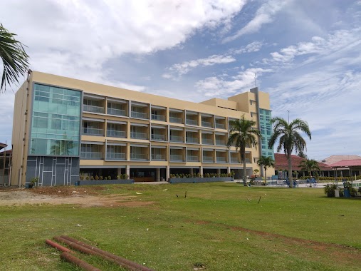
Hotel Cemara
Jalan Gading Cempaka No.47, Penurunan Indonesia
contacts phone
:
+62
Latitude:
-3.80716
, Longitude:
102.2675049
read more
nearest Lodging
223 m
Pondokan Wulan
Jalan Putri Gading Cempaka No.5, Penurunan
Lodging
read more
312 m
Hotel Ananda Bengkulu
Jalan Putri Gading Cempaka No.51, Penurunan
Lodging
read more
576 m
Puteri Gading Hotel
Jalan Sukajadi No.133, Anggut Bawah
Lodging
read more
583 m
Hotel Permata Gading
Jalan Sukajadi, Penurunan
Lodging
read more
705 m
Putri Gading Hotel
Jalan Sukajadi No.31, Anggut Bawah
Lodging
read more
754 m
Hotel Bumi Cendana
Kebun Beler
Lodging
read more
832 m
Mes bintang motor
Jalan Flamboyan 13, Kebun Kenanga
Lodging
read more
864 m
Bumi Endah Hotel
Jl. Fatmawati No. 29-30, Penurunan
Lodging
read more
882 m
Flamboyan Hotel
JL. Flamboyan Raya, No. 2-3 RT. 19, Kebun Kenanga
Lodging
read more
900 m
Fauzah Kost
Anggut Bawah
Lodging
read more
911 m
Hotel Niaga
Jl. Pantai Nala No.1, Anggut Bawah, Ratu Samban, Anggut Bawah
Lodging
read more
921 m
Grage Hotel Bengkulu
Jalan Kesehatan II No.2, Anggut Bawah
Lodging
read more
931 m
Wisata Hotel
JL. Letjen S Parman No.115, Padang Jati
Lodging
read more
954 m
Hayani Hotel
JL Letjen S Parman No.65, Kebun Kenanga
Lodging
read more
966 m
permata gading hotel
Jalan Pariwisata, Anggut Bawah
Lodging
read more
995 m
Kos Putri Azwar
Anggut Atas
Lodging
read more
1.012 km
Hotel Bumi Cendana
Jalan Ratu Agung, Anggut Bawah
Lodging
read more
1.05 km
Hotel Mercure Bengkulu
Padang Jati
Lodging
read more
1.052 km
Sederhana Losmen
Padang Jati
Lodging
read more
1.052 km
Selekta Abadi Hotel
Padang Jati
Lodging
read more
1.064 km
Kendi Wisma
Jalan Soekarno Hatta No.2, Anggut Dalam
Lodging
read more
1.072 km
Pavillion TrioVi
Jalan Kesehatan I No.36, RT.4, Anggut Atas
Lodging
read more
1.094 km
Hotel Bencoolen
Padang Jati
Lodging
read more
1.148 km
Bougainville Hotel
Jalan Jati 5 No.37, Sawah Lebar
Lodging
read more
1.357 km
Hotel Mercure
Jalan Semeru, Padang Jati
Lodging
read more
📑
all categories
Accounting
Administrative area level 1
Administrative area level 2
Airport
Amusement park
Aquarium
Art gallery
Atm
Bakery
Bank
Bar
Beauty salon
Bicycle store
Book store
Bowling alley
Bus station
Cafe
Campground
Car dealer
Car rental
Car repair
Car wash
Casino
Cemetery
Church
City hall
Clothing store
Colloquial area
Convenience store
Courthouse
Dentist
Department store
Doctor
Electrician
Electronics store
Embassy
Finance
Fire station
Florist
Food
Funeral home
Furniture store
Gas station
General contractor
Grocery or supermarket
Gym
Hair care
Hardware store
Health
Hindu Temple
Home goods store
Hospital
Insurance agency
Intersection
Jewelry store
Laundry
Lawyer
Library
Liquor store
Local government office
Locality
Locksmith
Lodging
Meal delivery
Meal takeaway
Mosque
Movie rental
Movie theater
Moving company
Museum
Natural feature
Neighborhood
Night club
Painter
Park
Parking
Pet store
Pharmacy
Physiotherapist
Place of worship
Plumber
Point of interest
Police
Political
Post office
Premise
Real estate agency
Restaurant
Roofing contractor
Route
Rv park, camping
School
Shoe store
Shopping mall
Spa
Stadium
Storage
Store
Subpremise
Supermarket
Synagogue
Taxi stand
Train station
Transit station
Travel agency
University
Veterinary care
Zoo
administrative area level 3
administrative area level 4
administrative area level 5
sublocality level 1
↑