Lodging nearby Bali Holiday Hotel
Indonesia
Lodging nearby Bali Holiday Hotel
Bali Holiday Hotel
Jalan Kuta, Pasawahan Indonesia
contacts phone
:
+62
Latitude:
-6.75101
, Longitude:
106.763
read more
nearest Lodging
63 m
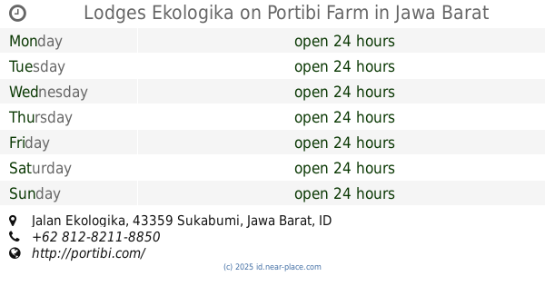
Lodges Ekologika on Portibi Farm
Jalan Ekologika, Pasawahan
Lodging
read more
1.659 km
Negla Sari
Tugujaya
Lodging
read more
1.731 km
Villa Susan Komplek Villa Orchid
desa J, Tugujaya
Lodging
read more
1.921 km
Bio Gas T T P Cigombong
Tugujaya
Lodging
read more
2.291 km
Pondok Sentosa 2
Unnamed Road, Tugujaya
Lodging
read more
3.277 km
Villa Loji
Pasirjaya
Lodging
read more
3.539 km
Villa NRK
Jalan Keloji G. Salak, Pasirjaya
Lodging
read more
3.603 km
Villa Kebon Ashri
Pasirjaya, Cigombong, Ciburayut
Lodging
read more
3.64 km
Villa FALIS
Jalan Keloji G. Salak, Pasirjaya
Lodging
read more
3.849 km
Villa Bunda
pasir jawa, Pasirjaya
Lodging
read more
3.862 km
Pondok Alam NaSri
kawungluwuk, kandang sapi,, Ciburayut
Lodging
read more
4.007 km
Mom & Pop's Family Cabins
Desa Saitem, Ciburayut
Lodging
read more
4.278 km
Homood Villa Bogor
Ciburayut
Lodging
read more
4.279 km
Uwa Kobul
Ciburayut
Lodging
read more
4.386 km
Villa OeL
Unnamed Rd,, Ciburayut
Lodging
read more
4.4 km
Sanggar Gumintang
Bangbayang
Lodging
read more
4.663 km
Villa Pitaya
Jalan Suka Bakti, Palasari
Lodging
read more
4.855 km
Mahir Farm
Cijeruk
Lodging
read more
4.991 km
Nano Residens
Jalan Raya Cigombong No.27, Cijeruk
Lodging
read more
5.036 km
Villa Yelo Pancasila Abadi
Cijeruk
Lodging
read more
5.045 km
Puncak Manik 1 Curug
Pasawahan
Lodging
read more
5.055 km
Hotel Seruni Gunung Salak
Pasawahan
Lodging
read more
5.143 km
Bukit Paralayang Cijeruk
kampung cijeruk desa, Cijeruk
Lodging
read more
5.326 km
villa SADRA
Unnamed Road,, Cijeruk
Lodging
read more
6.481 km
Gunung Sumbul
Gunung
Lodging
read more
📑
all categories
Accounting
Administrative area level 1
Administrative area level 2
Airport
Amusement park
Aquarium
Art gallery
Atm
Bakery
Bank
Bar
Beauty salon
Bicycle store
Book store
Bowling alley
Bus station
Cafe
Campground
Car dealer
Car rental
Car repair
Car wash
Casino
Cemetery
Church
City hall
Clothing store
Colloquial area
Convenience store
Courthouse
Dentist
Department store
Doctor
Electrician
Electronics store
Embassy
Finance
Fire station
Florist
Food
Funeral home
Furniture store
Gas station
General contractor
Grocery or supermarket
Gym
Hair care
Hardware store
Health
Hindu Temple
Home goods store
Hospital
Insurance agency
Intersection
Jewelry store
Laundry
Lawyer
Library
Liquor store
Local government office
Locality
Locksmith
Lodging
Meal delivery
Meal takeaway
Mosque
Movie rental
Movie theater
Moving company
Museum
Natural feature
Neighborhood
Night club
Painter
Park
Parking
Pet store
Pharmacy
Physiotherapist
Place of worship
Plumber
Point of interest
Police
Political
Post office
Premise
Real estate agency
Restaurant
Roofing contractor
Route
Rv park, camping
School
Shoe store
Shopping mall
Spa
Stadium
Storage
Store
Subpremise
Supermarket
Synagogue
Taxi stand
Train station
Transit station
Travel agency
University
Veterinary care
Zoo
administrative area level 3
administrative area level 4
administrative area level 5
sublocality level 1
↑