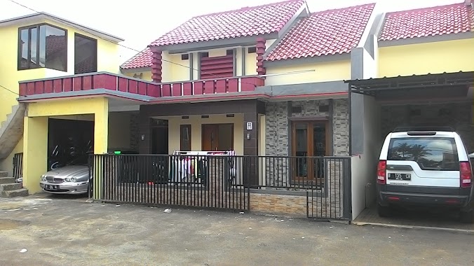
Local government office nearby Taman Permata Jenih
Indonesia
Local government office nearby Taman Permata Jenih
Taman Permata Jenih
Jalan Bumi Harapan Permata No.18, RT.7/RW.1, Rambutan Indonezja
contacts phone
:
+62
Latitude:
-6.2967836
, Longitude:
106.8734353
read more
nearest Local government office
310 m
samsat keliling
Pasar Induk Kramat Djati, Jalan Raya Bogor RT.9/RW.7, Kampung Tengah
Local government office
read more
489 m
Kantor Bardi
Jalan Raya Bogor No.1922, RT.2/RW.2, Rambutan
Local government office
read more
656 m
Dukuh Lurah Office
Jl. Dukuh V RT 7 RW 2, Kramat Jati, RT.7/RW.2, Dukuh
Local government office
read more
715 m
GRIYA DUKUH 263
Griya 263, no.22 Jl. Dukuh V (samping smp 263) Rt.10 rw.05 kel. Dukuh, kec. timur 13550, RT.8, Dukuh
Local government office
read more
749 m
Griya Rambutan Cluster
RT.4/RW.3, Rambutan
Local government office
read more
791 m
Yayasan Cinta Remaja Bangsa Unit Jakarta
Jalan Dukuh VI RT.7/RW.2, Dukuh
Local government office
read more
832 m
Pertiwi Residence
Jalan Haji Taiman No.13, RT.1/RW.2, Gedong
Local government office
read more
889 m
KONSUIL AREA KRAMAT JATI
3,, Jalan Raya Inpres No.2, RT.2/RW.2, Kampung Tengah
Local government office
read more
933 m
Bus Sekolah UPAS Dishub Jakarta
Jalan Bogor Raya No.33, RT.1/RW.2, Rambutan
Local government office
read more
971 m
11 Kelurahan Gedong
Jalan Haji Taiman No.28, RT.3/RW.10, Gedong
Local government office
read more
1.124 km
JACK Kantor Upt. Alkal
Jalan Haji Ahmad Tarmiji RT.15/RW.1, Pinang Ranti
Local government office
read more
1.125 km
Gerai Samsat STNK
Tamini Square Lt. UG Blok US 57 No. 4, Jl. Tmaan Mini Raya, Pinang Ranti, Makasar, RT.3/RW.2, Pinang Ranti
Local government office
read more
1.182 km
Griya Danakarya
Jalan Haji Taiman Barat I No.10, RT.2/RW.2, Gedong
Local government office
read more
1.329 km
Kantor Kecamatan Kramat Jati Jakarta Timur
Jalan Raya Bogor No.4, RT.14/RW.11, Kramat Jati
Local government office
read more
1.354 km
Griya Setya
Jalan Dana Prasetya No.24, RT.6/RW.8, Gedong
Local government office
read more
1.625 km
Balai Latihan Kerja Luar Negeri Yayasan Satria Mandiri
Jalan Raya Tengah No.50, RT.9/RW.3, Kampung Tengah
Local government office
read more
1.861 km
kantor lurah
RT.13/RW.6
Local government office
read more
1.908 km
Setu Medical Centre
Rukan Panorama, Jalan Raya Condet RT.1/RW.1, Gedong
Local government office
read more
1.913 km
Batu Jaya Townhouse
Batu Jaya Townhouse, jln mangga, RT.2/RW.3, Batu Ampar
Local government office
read more
2.013 km
Kantor Pengelola Gedung Sasono TMII
Ceger, Cipayung, Ceger
Local government office
read more
2.027 km
HAS Consulting Group
Perkantoran Zam-Zam Square Unit 8, Jalan Raya Condet No.4
Local government office
read more
2.027 km
HAS Consulting Group
Perkantoran Zam-Zam Square Unit 8, Jalan Raya Condet No.4, RT.5/RW.3, Bale Kambang
Local government office
read more
2.26 km
PT Alqurrny Bagas Pratama
Jalan Raya Condet No.3, RT.10/RW.3, Balekambang
Local government office
read more
2.307 km
Grand Crystal Town House
Jalan Batu Ampar III No.10, RT.14/RW.3, Batu Ampar
Local government office
read more
2.333 km
Perumahan Calista7 Batu Ampar 3
Jalan Raya Condet No.3, RT.9/RW.3, Batu Ampar
Local government office
read more
📑
all categories
Accounting
Administrative area level 1
Administrative area level 2
Airport
Amusement park
Aquarium
Art gallery
Atm
Bakery
Bank
Bar
Beauty salon
Bicycle store
Book store
Bowling alley
Bus station
Cafe
Campground
Car dealer
Car rental
Car repair
Car wash
Casino
Cemetery
Church
City hall
Clothing store
Colloquial area
Convenience store
Courthouse
Dentist
Department store
Doctor
Electrician
Electronics store
Embassy
Finance
Fire station
Florist
Food
Funeral home
Furniture store
Gas station
General contractor
Grocery or supermarket
Gym
Hair care
Hardware store
Health
Hindu Temple
Home goods store
Hospital
Insurance agency
Intersection
Jewelry store
Laundry
Lawyer
Library
Liquor store
Local government office
Locality
Locksmith
Lodging
Meal delivery
Meal takeaway
Mosque
Movie rental
Movie theater
Moving company
Museum
Natural feature
Neighborhood
Night club
Painter
Park
Parking
Pet store
Pharmacy
Physiotherapist
Place of worship
Plumber
Point of interest
Police
Political
Post office
Premise
Real estate agency
Restaurant
Roofing contractor
Route
Rv park, camping
School
Shoe store
Shopping mall
Spa
Stadium
Storage
Store
Subpremise
Supermarket
Synagogue
Taxi stand
Train station
Transit station
Travel agency
University
Veterinary care
Zoo
administrative area level 3
administrative area level 4
administrative area level 5
sublocality level 1
↑