Local government office nearby Puskesmas Desa Dago
Indonesia
Local government office nearby Puskesmas Desa Dago
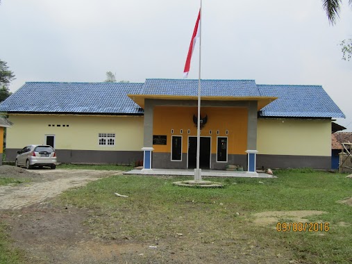
Puskesmas Desa Dago
Dago, Parung Panjang, Bogor, West Java 16360, Indonezja
contacts phone
:
+62
Latitude:
-6.4077438
, Longitude:
106.5879953
larger map & directions
read more
nearest Local government office
904 m
Desa Dago Mba Pia
Dago
Local government office
read more
3.374 km
Village Head Office Kertajaya
Jalan Raya Cikandang No.1, Kertajaya
Local government office
read more
3.906 km
Puskesmas Gorowong
Gorowong
Local government office
read more
3.934 km
Kantor Desa Cikuda
Jalan Raya Dago, Cikuda
Local government office
read more
4.202 km
Kantor Kepala Desa Mekarsari
Mekar Sari
Local government office
read more
4.464 km
Kantor Desa Gorowong
Gorowong
Local government office
read more
4.791 km
UPT PTPH I Parungpanjang
Jagabaya
Local government office
read more
5.32 km
griya Parung Panjang
Unnamed Road, Kabasiran
Local government office
read more
5.504 km
Kantor Desa Sukamulya
Jalan Raya Rumpin, Sukamulya
Local government office
read more
8.7 km
GSA ASTER
Jalan Raya Serpong Rumpin No.109, Suradita
Local government office
read more
10.817 km
Mayor of South Jakarta Housing
16330, Jalan Raya Haji Usa, Cibeuteung Muara
Local government office
read more
12.99 km
Satuan Polisi Pamong Praja (Satpol PP) Kota Tangerang Selatan
Setu
Local government office
read more
13.294 km
Komplek Posgiro Serpong
Jaletreng 15310, Serpong
Local government office
read more
14.228 km
Perum. Villa Waru
Unnamed Road, Waru
Local government office
read more
14.267 km
Gedung Biru
Jalan Atmaja No.84, Bakti Jaya
Local government office
read more
14.556 km
Kantor Kelurahan Bakti Jaya
Bakti Jaya
Local government office
read more
15.72 km
KADIN Kota Tangerang Selatan
Ruko Golden Road, Jl. NN Blok C1 No.30, Lengkong Gudang, Serpong
Local government office
read more
15.781 km
Perumahan Griya Pamulang Asri
Jalan Inpres No.44, Benda Baru, Pamulang, Benda Baru
Local government office
read more
15.79 km
TABG Tangsel
Lengkong Gudang
Local government office
read more
15.899 km
Perumahan Muslim Al Falaah 3
Jalan Salak Raya, Pondok Benda
Local government office
read more
16.026 km
Pondok Benda Residen
Jalan Salak IX No.13, Pondok Benda
Local government office
read more
16.546 km
Pearl Cluster Tigaraksa 2
Jambe
Local government office
read more
16.76 km
Kantor Polresta Tangerang Selatan
Jalan Kampung Lengkong No.48, Lengkong Gudang Timur
Local government office
read more
17.048 km
Perumahan Serua Barokah
Jalan Palapa, Serua
Local government office
read more
19.098 km
Green Gardena
Jalan Cendrawasih I No.104-105, Sawah Baru
Local government office
read more
📑
all categories
Accounting
Administrative area level 1
Administrative area level 2
Airport
Amusement park
Aquarium
Art gallery
Atm
Bakery
Bank
Bar
Beauty salon
Bicycle store
Book store
Bowling alley
Bus station
Cafe
Campground
Car dealer
Car rental
Car repair
Car wash
Casino
Cemetery
Church
City hall
Clothing store
Colloquial area
Convenience store
Courthouse
Dentist
Department store
Doctor
Electrician
Electronics store
Embassy
Finance
Fire station
Florist
Food
Funeral home
Furniture store
Gas station
General contractor
Grocery or supermarket
Gym
Hair care
Hardware store
Health
Hindu Temple
Home goods store
Hospital
Insurance agency
Intersection
Jewelry store
Laundry
Lawyer
Library
Liquor store
Local government office
Locality
Locksmith
Lodging
Meal delivery
Meal takeaway
Mosque
Movie rental
Movie theater
Moving company
Museum
Natural feature
Neighborhood
Night club
Painter
Park
Parking
Pet store
Pharmacy
Physiotherapist
Place of worship
Plumber
Point of interest
Police
Political
Post office
Premise
Real estate agency
Restaurant
Roofing contractor
Route
Rv park, camping
School
Shoe store
Shopping mall
Spa
Stadium
Storage
Store
Subpremise
Supermarket
Synagogue
Taxi stand
Train station
Transit station
Travel agency
University
Veterinary care
Zoo
administrative area level 3
administrative area level 4
administrative area level 5
sublocality level 1
↑