Local government office nearby Bumi Parahyangan Kencana
Coronavirus disease (COVID-19) Situation
confirmed cases
6829221
deaths
162063
Indonesia
Local government office nearby Bumi Parahyangan Kencana
Bumi Parahyangan Kencana
blok E, Jalan Merdeka No.56, Babakan Ciamis Indonesia
contacts phone
:
+62
Latitude:
-6.9082042
, Longitude:
107.6108738
read more
nearest Local government office
142 m
BPMPT West Java Province
Jalan Sumatra No.50, Citarum
Local government office
read more
276 m
Bandung Planning Gallery
Jalan Aceh No.36, Babakan Ciamis
Local government office
read more
307 m
Kantor Walikota Bandung
Jalan Merdeka, Babakan Ciamis
Local government office
read more
322 m
Kantor Walikota Bandung
Jalan Wastukancana No.2, Babakan Ciamis
Local government office
read more
324 m
Kantor Advokat Dan Konsultan Hukum Rikhi Lazuardi SH., MH., & Rekan
Jalan Wastukancana No.31, Babakan Ciamis
Local government office
read more
332 m
Bandung Command Center
Jalan Wastukancana No.2, Babakan Ciamis
Local government office
read more
335 m
Dinas Kependudukan dan Catatan Sipil Kota Bandung
Jalan Ambon No.1, Citarum
Local government office
read more
336 m
Dinas Kesehatan
Jalan Ternate No.2, Citarum
Local government office
read more
338 m
Kantor Catatan Sipil Kota Bandung
Citarum
Local government office
read more
427 m
Bandung City Government
Jalan Wastukancana No.2, Babakan Ciamis
Local government office
read more
591 m
Bandung City Government
Jl. Wastukencana No. 2, Babakan Ciamis
Local government office
read more
592 m
Portal Bandung
Jalan Wastukancana No.2, Babakan Ciamis
Local government office
read more
617 m
Kogartap II (Garnisun) Bandung
Jalan Nias No.3, Babakan Ciamis
Local government office
read more
654 m
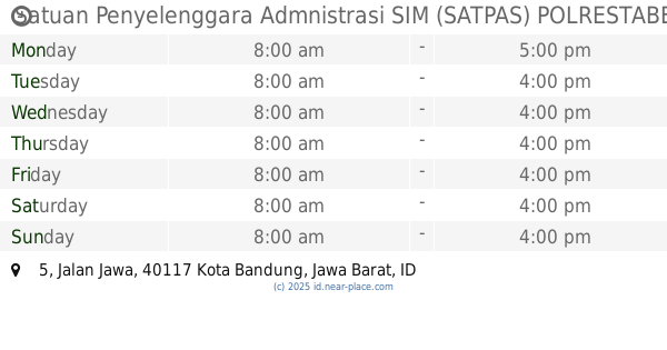
Satuan Penyelenggara Admnistrasi SIM (SATPAS) POLRESTABES BANDUNG
Jalan Jawa No.5, Babakan Ciamis
Local government office
read more
743 m
GSG - Kantor RW 01 Gubernuran
Jalan Kebon Sirih No.1, Babakan Ciamis
Local government office
read more
783 m
Gedung Pakuan
Jl. Cicendo No 1 Pasir Kaliki Bandung, Babakan Ciamis
Local government office
read more
826 m
INSPEKTORAT KOTA BANDUNG(IRBANSUS)
Jalan Tera No.20, Braga
Local government office
read more
972 m
Pilkada Jabar
Citarum
Local government office
read more
1.036 km
Fraksi PKB DPRD Jabar
Jalan Diponegoro No.20, Citarum
Local government office
read more
1.05 km
Fraksi Partai Demokrat DPRD Prov. Jawa Barat
No., Jalan Diponegoro No.27, Citarum
Local government office
read more
1.068 km
MENARA GEDUNG SATE
Jalan Diponegoro No.22, Citarum
Local government office
read more
1.142 km
Lapangan Arhanudri 3
Jalan Menado No.12, Merdeka
Local government office
read more
1.161 km
Badan Pengelolaan Keuangan dan Aset Daerah Provinsi Jawa Barat
Jalan Diponegoro No.22, Citarum
Local government office
read more
1.274 km
Madya Office (GT-PAG)
Jalan Diponegoro No.57, Cihaur Geulis
Local government office
read more
1.62 km
Kantor Wilayah Direktorat Jenderal Bea dan Cukai (DJBC)
Jalan Asia Afrika No.114, Kebon Pisang
Local government office
read more
📑
all categories
Accounting
Administrative area level 1
Administrative area level 2
Airport
Amusement park
Aquarium
Art gallery
Atm
Bakery
Bank
Bar
Beauty salon
Bicycle store
Book store
Bowling alley
Bus station
Cafe
Campground
Car dealer
Car rental
Car repair
Car wash
Casino
Cemetery
Church
City hall
Clothing store
Colloquial area
Convenience store
Courthouse
Dentist
Department store
Doctor
Electrician
Electronics store
Embassy
Finance
Fire station
Florist
Food
Funeral home
Furniture store
Gas station
General contractor
Grocery or supermarket
Gym
Hair care
Hardware store
Health
Hindu Temple
Home goods store
Hospital
Insurance agency
Intersection
Jewelry store
Laundry
Lawyer
Library
Liquor store
Local government office
Locality
Locksmith
Lodging
Meal delivery
Meal takeaway
Mosque
Movie rental
Movie theater
Moving company
Museum
Natural feature
Neighborhood
Night club
Painter
Park
Parking
Pet store
Pharmacy
Physiotherapist
Place of worship
Plumber
Point of interest
Police
Political
Post office
Premise
Real estate agency
Restaurant
Roofing contractor
Route
Rv park, camping
School
Shoe store
Shopping mall
Spa
Stadium
Storage
Store
Subpremise
Supermarket
Synagogue
Taxi stand
Train station
Transit station
Travel agency
University
Veterinary care
Zoo
administrative area level 3
administrative area level 4
administrative area level 5
sublocality level 1
↑