Hospital nearby Puskesmas Bogor Utara
Indonesia
Hospital nearby Puskesmas Bogor Utara
Puskesmas Bogor Utara
Jalan Tegallega No.7-13, Tegallega Indonesia
contacts phone
:
+62
Latitude:
-6.5920908
, Longitude:
106.8144887
read more
nearest Hospital
89 m
klinik tegallega
Jalan Tegallega No.13, Tegallega
Hospital
read more
328 m
Petshop Johan & Sam & Cooper
Jalan Cimandiri, Tegal Gundil
Hospital
read more
511 m
Budy Santoso
Kampung Parung Jambu, Tegal Gundil
Hospital
read more
847 m
RS PMI Bogor Igd
Jalan Malabar Ujung No.16, Tegallega
Hospital
read more
897 m
Posyandu Anggrek
Jl Kondang No.9, Babakan
Hospital
read more
913 m
RS PMI IGD
Jalan Rumah Sakit I, Tegallega
Hospital
read more
914 m
RS.PMI IGD BOGOR
Jalan Taman Malabar, Babakan
Hospital
read more
955 m
Rumah Sakit Mulia
Jalan Cidangiang, Tegallega
Hospital
read more
974 m
RS GRIYA DRAMAGA
Jl. Jagung No. 14, RT. 001 RW. 09, Ciheuleut, Tim. 16143, Baranangsiang
Hospital
read more
976 m
Patyaaa
Baranangsiang
Hospital
read more
985 m
KLINIKA VENEER GIGI
Jalan Kumbang, Babakan
Hospital
read more
994 m
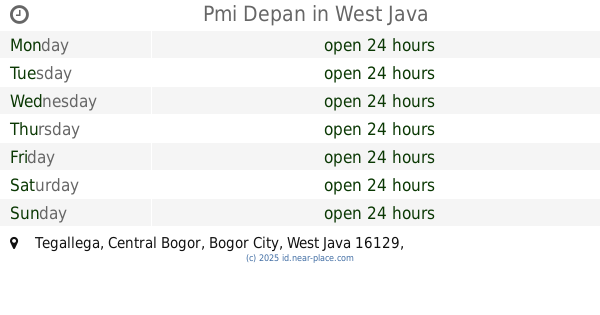
Pmi Depan
Tegallega
Hospital
read more
1.028 km
RS PMI BOGOR
Jalan Rumah Sakit I, Tegallega
Hospital
read more
1.056 km
Rs PMI BOGOR
Tegallega, Bogor Tengah
Hospital
read more
1.089 km
Rumah Sakit Karya Mandiri Utama
Kampung Parung Jambu, Babakan
Hospital
read more
1.089 km
Puskesmas Pasir Orai
jalan pasir orai desa, Cinangka
Hospital
read more
1.161 km
POTI BOGOR
Kampung Parung Jambu, Tegallega
Hospital
read more
1.187 km
EBONI Ruang Perawatan VIP
Tegallega
Hospital
read more
1.271 km
Rs Pmi Bogor Utama
Tegallega, Bogor Tengah, Tegallega
Hospital
read more
1.287 km
Bedah Urologi
Tegallega
Hospital
read more
1.287 km
Psikolog
Tegallega
Hospital
read more
1.287 km
Klinik Kosmetik Medik
Tegallega
Hospital
read more
1.287 km
Fisioterapi
Tegallega
Hospital
read more
1.287 km
Bedah Mulut
Tegallega
Hospital
read more
1.287 km
Bedah Saraf
Tegallega
Hospital
read more
📑
all categories
Accounting
Administrative area level 1
Administrative area level 2
Airport
Amusement park
Aquarium
Art gallery
Atm
Bakery
Bank
Bar
Beauty salon
Bicycle store
Book store
Bowling alley
Bus station
Cafe
Campground
Car dealer
Car rental
Car repair
Car wash
Casino
Cemetery
Church
City hall
Clothing store
Colloquial area
Convenience store
Courthouse
Dentist
Department store
Doctor
Electrician
Electronics store
Embassy
Finance
Fire station
Florist
Food
Funeral home
Furniture store
Gas station
General contractor
Grocery or supermarket
Gym
Hair care
Hardware store
Health
Hindu Temple
Home goods store
Hospital
Insurance agency
Intersection
Jewelry store
Laundry
Lawyer
Library
Liquor store
Local government office
Locality
Locksmith
Lodging
Meal delivery
Meal takeaway
Mosque
Movie rental
Movie theater
Moving company
Museum
Natural feature
Neighborhood
Night club
Painter
Park
Parking
Pet store
Pharmacy
Physiotherapist
Place of worship
Plumber
Point of interest
Police
Political
Post office
Premise
Real estate agency
Restaurant
Roofing contractor
Route
Rv park, camping
School
Shoe store
Shopping mall
Spa
Stadium
Storage
Store
Subpremise
Supermarket
Synagogue
Taxi stand
Train station
Transit station
Travel agency
University
Veterinary care
Zoo
administrative area level 3
administrative area level 4
administrative area level 5
sublocality level 1
↑