Gym nearby Auroeria Valent
Coronavirus disease (COVID-19) Situation
confirmed cases
6829221
deaths
162063
Indonesia
Gym nearby Auroeria Valent
Auroeria Valent
27, Jalan Perum Ganesha, 16310, Bogor, Jawa Barat, ID Indonezja
contacts phone
:
+62
Latitude:
-6.4838891
, Longitude:
106.6958419
larger map & directions
read more
nearest Gym
1.645 km
BODY ARMY GYM/ FITNESS CENTRE
Jl. Teras 2 candraloka aa6/25 rt 02/011, Tegal
Gym
read more
2.374 km
Panti Pijat Ki ijom Gang Berenuk
Jalan Haji Miing, Karihkil
Gym
read more
2.618 km
Lapangan Tenis
Babakan
Gym
read more
2.813 km
Lapangan Mutiara
Babakan
Gym
read more
4.002 km
Roby Gym
Cidokom
Gym
read more
4.454 km
Lapangan Bulutangkis Butonk
cibar butong, Cimulang
Gym
read more
4.53 km
Pos Ronda Gg Makmur Babakan
Unnamed Road, Pondok Udik
Gym
read more
4.578 km
IKH Gym And Men Spa
Jalan Raya Cibodas, Cibodas
Gym
read more
4.615 km
Lapang Badminton
Jabon Mekar
Gym
read more
5.027 km
Gedung Taekwondo Al Ashriyyah Nurul Iman
Warujaya
Gym
read more
5.16 km
Rizky Berkah Jamu Seduh
Jalan AMD Cibentang, Cibentang
Gym
read more
5.213 km
Rendy Fitnes Club
Jalan Raya Kalisuren
Gym
read more
5.617 km
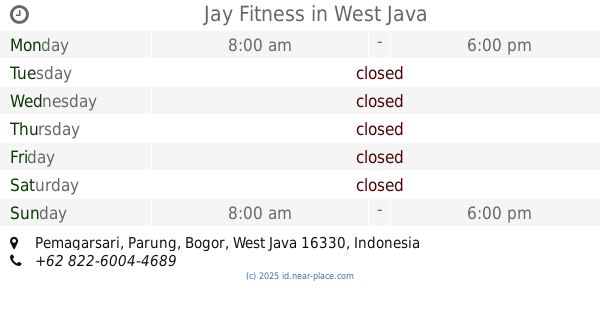
Jay Fitness
Pemagarsari
Gym
read more
5.735 km
ARGO FC
Jalan Raya Gobang, Gobang
Gym
read more
5.84 km
Galatama Lele Riko
Pemagarsari
Gym
read more
6.101 km
Lapangan Bulu Tangkis
Kalisuren
Gym
read more
6.158 km
Lapangan Badminton
Jalan H. Nani No.51, Pemagarsari
Gym
read more
8.695 km
Taman Angin Angin Pura
Jalan Bandung 7, Tajurhalang
Gym
read more
9.956 km
Lapangan GERHANA FC
Kayu Manis
Gym
read more
11.623 km
Villa Pabuaran Pradana
Jalan Kompleks Departemen Agama Ri No.57, Pabuaran
Gym
read more
14.746 km
NAMI NAMONG
Serpong, Jalan Kompleks Panorama No.26, RT.002/RW.OO2, Bakti Jaya
Gym
read more
16.602 km
Kursus Yoga
Blok, Jalan Mahoni Raya Blok H No.12A, Mekarjaya
Gym
read more
16.628 km
Lapangan Basket Sempur
Sempur
Gym
read more
17.058 km
Selang Jogging Club
Babakan
Gym
read more
19.34 km
ARITA CLUB
Jalan Timbul No.002/003, RT.4 RT/RW.3, Cipedak
Gym
read more
📑
all categories
Accounting
Administrative area level 1
Administrative area level 2
Airport
Amusement park
Aquarium
Art gallery
Atm
Bakery
Bank
Bar
Beauty salon
Bicycle store
Book store
Bowling alley
Bus station
Cafe
Campground
Car dealer
Car rental
Car repair
Car wash
Casino
Cemetery
Church
City hall
Clothing store
Colloquial area
Convenience store
Courthouse
Dentist
Department store
Doctor
Electrician
Electronics store
Embassy
Finance
Fire station
Florist
Food
Funeral home
Furniture store
Gas station
General contractor
Grocery or supermarket
Gym
Hair care
Hardware store
Health
Hindu Temple
Home goods store
Hospital
Insurance agency
Intersection
Jewelry store
Laundry
Lawyer
Library
Liquor store
Local government office
Locality
Locksmith
Lodging
Meal delivery
Meal takeaway
Mosque
Movie rental
Movie theater
Moving company
Museum
Natural feature
Neighborhood
Night club
Painter
Park
Parking
Pet store
Pharmacy
Physiotherapist
Place of worship
Plumber
Point of interest
Police
Political
Post office
Premise
Real estate agency
Restaurant
Roofing contractor
Route
Rv park, camping
School
Shoe store
Shopping mall
Spa
Stadium
Storage
Store
Subpremise
Supermarket
Synagogue
Taxi stand
Train station
Transit station
Travel agency
University
Veterinary care
Zoo
administrative area level 3
administrative area level 4
administrative area level 5
sublocality level 1
↑