Grocery or supermarket nearby Kusuma Kaisan
Indonesia
Grocery or supermarket nearby Kusuma Kaisan
Kusuma Kaisan
Jalan Lintang Raya, Sentul Indonesien
contacts phone
:
+62
Latitude:
-6.5179233
, Longitude:
106.8529221
read more
nearest Grocery or supermarket
356 m
warung ade ago
Jalan Lan Bau No.9, Sentul
Grocery or supermarket
read more
497 m
Warung Sayur Checep
Jalan Babakan Rawa Haur No.52-24, Sentul
Grocery or supermarket
read more
725 m
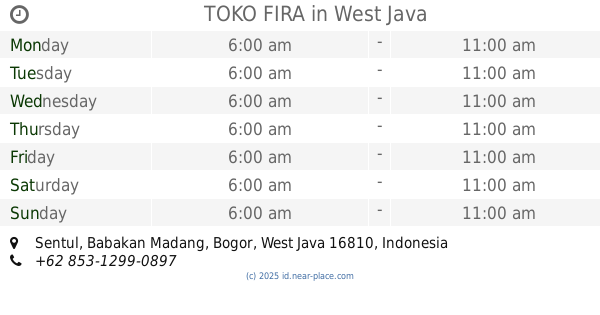
TOKO FIRA
Sentul
Grocery or supermarket
read more
748 m
Toko Fira Jaya
Sentul
Grocery or supermarket
read more
772 m
Olympic CBD
Jalan Olympic Raya, Sentul
Grocery or supermarket
read more
833 m
Indomaret Gg.Oleh
Jalan Tangkil - Agrabinta No.47, Leuwinutug
Grocery or supermarket
read more
912 m
Aef Speed Shoop
kp rt/rw 04/06 desa, Jalan Babakan Rawa Haur, Sentul
Grocery or supermarket
read more
969 m
Aef Home Stay
kp rt/rw 04/06 desa, Jalan Babakan Rawa Haur, Sentul
Grocery or supermarket
read more
978 m
Warung Rey
Jalan Babakan Rawa Haur, Sentul
Grocery or supermarket
read more
1.009 km
Toko Raffy Snack
Jalan Pahlawan, Sentul
Grocery or supermarket
read more
1.153 km
Cerkuit Sentul
Jalan Raya Sirkuit Sentul, Sentul
Grocery or supermarket
read more
1.182 km
warung Yaman
Jalan Desa Leuwinutug No.32-19, Leuwinutug
Grocery or supermarket
read more
1.215 km
Toko Anugrah
Rt 001 Rw 03 Kecamatan Citeureup, Jalan Raya Sirkuit Sentul, Sentul
Grocery or supermarket
read more
1.384 km
Toko Koperasi Mentos
Jalan Raya Bogor - Jakarta No.6, Nanggewer
Grocery or supermarket
read more
1.401 km
Warung Sitante
Jalan Raya Sirkuit Sentul No.65-67, Sentul
Grocery or supermarket
read more
1.493 km
Warung Alat Tulis *gilang Makmur*
Jalan Kampung Jolok Setu No.56-57, Leuwinutug
Grocery or supermarket
read more
1.503 km
Rumah Sahrul Hidayat (Engkoh)
Jalan Alternatif Sentul No.5 C, Cijujung
Grocery or supermarket
read more
1.545 km
DEPOT AIR ISI ULANG RIZKI RAMA
Leuwinutug
Grocery or supermarket
read more
1.627 km
Warung Dali
Jalan Alternatif Sentul, Sentul
Grocery or supermarket
read more
1.659 km
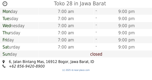
Toko 28
Jalan Bintang Mas No.6, Nanggewer
Grocery or supermarket
read more
1.829 km
BYEES
21, Jl.Tatya Asri II JC, Cijujung
Grocery or supermarket
read more
1.917 km
Alfamart Kandang Roda
Jalan Raya Bogor - Jakarta, Nanggewer
Grocery or supermarket
read more
1.942 km
bintang mas nagewer
Jalan Bintang Mas, Nanggewer
Grocery or supermarket
read more
2.127 km
Warung Lipong
Jalan Murai, Nanggewer Mekar
Grocery or supermarket
read more
2.325 km
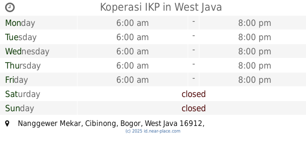
Koperasi IKP
Nanggewer Mekar
Grocery or supermarket
read more
📑
all categories
Accounting
Administrative area level 1
Administrative area level 2
Airport
Amusement park
Aquarium
Art gallery
Atm
Bakery
Bank
Bar
Beauty salon
Bicycle store
Book store
Bowling alley
Bus station
Cafe
Campground
Car dealer
Car rental
Car repair
Car wash
Casino
Cemetery
Church
City hall
Clothing store
Colloquial area
Convenience store
Courthouse
Dentist
Department store
Doctor
Electrician
Electronics store
Embassy
Finance
Fire station
Florist
Food
Funeral home
Furniture store
Gas station
General contractor
Grocery or supermarket
Gym
Hair care
Hardware store
Health
Hindu Temple
Home goods store
Hospital
Insurance agency
Intersection
Jewelry store
Laundry
Lawyer
Library
Liquor store
Local government office
Locality
Locksmith
Lodging
Meal delivery
Meal takeaway
Mosque
Movie rental
Movie theater
Moving company
Museum
Natural feature
Neighborhood
Night club
Painter
Park
Parking
Pet store
Pharmacy
Physiotherapist
Place of worship
Plumber
Point of interest
Police
Political
Post office
Premise
Real estate agency
Restaurant
Roofing contractor
Route
Rv park, camping
School
Shoe store
Shopping mall
Spa
Stadium
Storage
Store
Subpremise
Supermarket
Synagogue
Taxi stand
Train station
Transit station
Travel agency
University
Veterinary care
Zoo
administrative area level 3
administrative area level 4
administrative area level 5
sublocality level 1
↑