Gas station nearby SPBU Saranani
Coronavirus disease (COVID-19) Situation
confirmed cases
6829221
deaths
162063
Indonesia
Gas station nearby SPBU Saranani
SPBU Saranani
Jalan Malik Raya, Korumba Indonesia
contacts phone
:
+62
Latitude:
-3.9717846
, Longitude:
122.519609
read more
nearest Gas station
785 m
Warung Mas Eka
Korumba
Gas station
read more
898 m
SPBU Pertamina Tapal kuda
Korumba
Gas station
read more
1.314 km
SPBU H.BATARAI
Mandonga
Gas station
read more
1.335 km
SPBU Pertamina Punggolaka
Mandonga
Gas station
read more
1.476 km
SPBU Rabam
Jalan Ahmad Yani, Bende
Gas station
read more
1.494 km
SPBU Ahmad Yani
Bende
Gas station
read more
2.078 km
Pertamina
Watu-Watu
Gas station
read more
2.085 km
SPBU TERATAI KENDARI
Watu-Watu
Gas station
read more
2.542 km
Pertamina
Jalan Budi Utomo, Kadia, Mataiwoi
Gas station
read more
2.557 km
SPBU THR
Jalan Budi Utomo No.34, Mataiwoi
Gas station
read more
2.76 km
XL Center Kendari
Lorong Sahara No.167, Anaiwoi, Kadia
Gas station
read more
2.76 km
XL Center Kendari
Jl. Ahmad Yani No. 167, Kel. Anaiwoi, Kec. Kadia, Anaiwoi
Gas station
read more
3.174 km
SPBU Pertamina Tipulu
Tipulu
Gas station
read more
3.192 km
Pertamina gas station 74-931.08
Jalan Mayjen. Sutoyo, Tipulu, Kendari Barat, Tipulu, Kendari Barat, Tipulu
Gas station
read more
3.525 km
Pertamina
Kambu
Gas station
read more
3.531 km
SPBU Martandu
Kambu
Gas station
read more
3.549 km
SPBU Pertamina Anduonohu
Kambu
Gas station
read more
3.775 km
Pertamini Digital Da Sepatu
Kambu
Gas station
read more
4.005 km
SPBU Taruna Bumi
Jalan Jendral A Yani No.133, Bonggoeya
Gas station
read more
4.357 km
SPBU Bonggoeya
Bonggoeya
Gas station
read more
4.365 km
Pertamina
Bonggoeya
Gas station
read more
4.926 km
SPBU Polres Kendari
Bonggoeya
Gas station
read more
5.125 km
SPBT TNI
Wundudopi
Gas station
read more
7.929 km
Pertamina
Jalan Kapten Piere Tendean, Baruga
Gas station
read more
7.931 km
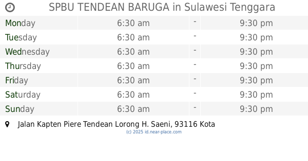
SPBU TENDEAN BARUGA
Jalan Kapten Piere Tendean Lorong H. Saeni, Baruga
Gas station
read more
📑
all categories
Accounting
Administrative area level 1
Administrative area level 2
Airport
Amusement park
Aquarium
Art gallery
Atm
Bakery
Bank
Bar
Beauty salon
Bicycle store
Book store
Bowling alley
Bus station
Cafe
Campground
Car dealer
Car rental
Car repair
Car wash
Casino
Cemetery
Church
City hall
Clothing store
Colloquial area
Convenience store
Courthouse
Dentist
Department store
Doctor
Electrician
Electronics store
Embassy
Finance
Fire station
Florist
Food
Funeral home
Furniture store
Gas station
General contractor
Grocery or supermarket
Gym
Hair care
Hardware store
Health
Hindu Temple
Home goods store
Hospital
Insurance agency
Intersection
Jewelry store
Laundry
Lawyer
Library
Liquor store
Local government office
Locality
Locksmith
Lodging
Meal delivery
Meal takeaway
Mosque
Movie rental
Movie theater
Moving company
Museum
Natural feature
Neighborhood
Night club
Painter
Park
Parking
Pet store
Pharmacy
Physiotherapist
Place of worship
Plumber
Point of interest
Police
Political
Post office
Premise
Real estate agency
Restaurant
Roofing contractor
Route
Rv park, camping
School
Shoe store
Shopping mall
Spa
Stadium
Storage
Store
Subpremise
Supermarket
Synagogue
Taxi stand
Train station
Transit station
Travel agency
University
Veterinary care
Zoo
administrative area level 3
administrative area level 4
administrative area level 5
sublocality level 1
↑