Gas station nearby Gas Station 34 -16926
Indonesia
Gas station nearby Gas Station 34 -16926
Gas Station 34 -16926
Jalan Raya Kusumayadi, Tengah Indonesia
contacts phone
:
+62
Latitude:
-6.4723672
, Longitude:
106.822026
read more
nearest Gas station
32 m
Bc Ubc Uber Bogor Club
Jalan KSR Dadi Kusmayadi, Tengah
Gas station
read more
540 m
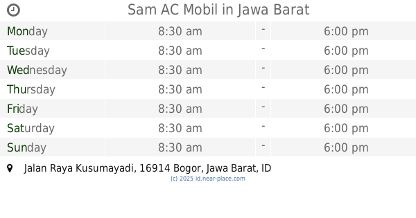
Sam AC Mobil
Jalan Raya Kusumayadi, Sukahati
Gas station
read more
776 m
SPBU Pertamina
Pondok Rajeg
Gas station
read more
899 m
Pertamina gas station 34.169.30
Jalan KSR Dadi Kusmayadi, Tengah
Gas station
read more
1.637 km
Spbe Raja Gas
Jatimulya
Gas station
read more
1.655 km
PT.Gas Elpiji Negara
Jalan Al-Hawi Blok Central No.23, RT.1/RW.11, Jatimulya
Gas station
read more
1.786 km
Bengkel Las Bubut
Jalan Raya Kampung Sawah, Jatimulya
Gas station
read more
2.094 km
Pertamina
Jalan Raya Cikaret No.53, RT.2/RW.1, Harapan Jaya
Gas station
read more
2.114 km
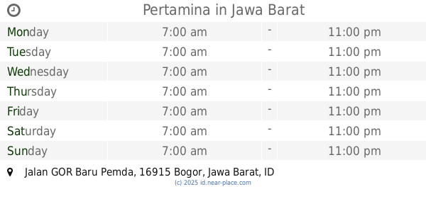
Pertamina
Jalan GOR Baru Pemda, Pakansari
Gas station
read more
2.121 km
Pemda Gas Station
Pakansari
Gas station
read more
2.283 km
Pertamina Spbu Pertamina Spbu
Jalan Kampung Padurenan No.17, RT.2/RW.13, Harapan Jaya
Gas station
read more
2.634 km
Star Motor
Jl. Raya Cibinong Km. 49 Cibinong Cibinong Kabupaten Bogor Jawa Barat, Pabuaran
Gas station
read more
2.677 km
SPBU 34.16123
Jalan Raya Bojong Gede, Bojong Gede, Bojonggede
Gas station
read more
2.716 km
SPBU 34-16906
Jalan Raya Bogor Blok Haji Abd Gani No.1, RT.2/RW.11, Pabuaran
Gas station
read more
2.747 km
Pertimina
Jalan Raya Bogor Blok Haji Abd Gani No.1, RT.2/RW.11, Pabuaran
Gas station
read more
2.929 km
Pertamini
Jalan Majapahit Raya, Pabuaran
Gas station
read more
2.999 km
PERTAMINI BABEH
Pabuaran
Gas station
read more
3.118 km
SPBU 34-16935
Jalan Raya Bogor, Cibinong
Gas station
read more
3.148 km
Bensin Eceran Bang Aput
Jalan Plered Raya, Pabuaran
Gas station
read more
3.199 km
Spbe Draf Gasitas
Jalan Raya Sukahati No.47, Sukahati
Gas station
read more
3.229 km
Sppbe
Jalan Raya Muara Beres, Sukahati
Gas station
read more
3.351 km
pos lebak
Jalan Lebak Pos No.45, Bojong Pondok Terong
Gas station
read more
3.599 km
Jalan Setasiun Bojonggede, Pasar Lama
Gang Pasar Lama, Bojonggede
Gas station
read more
4.189 km
Pertamina
Jalan Raya Bojong Gede No.10, RT.3/RW.5, Kedung Waringin
Gas station
read more
4.19 km
Pertamina Bojong Gede
Jalan Haji Abdul Halim, Kedung Waringin
Gas station
read more
📑
all categories
Accounting
Administrative area level 1
Administrative area level 2
Airport
Amusement park
Aquarium
Art gallery
Atm
Bakery
Bank
Bar
Beauty salon
Bicycle store
Book store
Bowling alley
Bus station
Cafe
Campground
Car dealer
Car rental
Car repair
Car wash
Casino
Cemetery
Church
City hall
Clothing store
Colloquial area
Convenience store
Courthouse
Dentist
Department store
Doctor
Electrician
Electronics store
Embassy
Finance
Fire station
Florist
Food
Funeral home
Furniture store
Gas station
General contractor
Grocery or supermarket
Gym
Hair care
Hardware store
Health
Hindu Temple
Home goods store
Hospital
Insurance agency
Intersection
Jewelry store
Laundry
Lawyer
Library
Liquor store
Local government office
Locality
Locksmith
Lodging
Meal delivery
Meal takeaway
Mosque
Movie rental
Movie theater
Moving company
Museum
Natural feature
Neighborhood
Night club
Painter
Park
Parking
Pet store
Pharmacy
Physiotherapist
Place of worship
Plumber
Point of interest
Police
Political
Post office
Premise
Real estate agency
Restaurant
Roofing contractor
Route
Rv park, camping
School
Shoe store
Shopping mall
Spa
Stadium
Storage
Store
Subpremise
Supermarket
Synagogue
Taxi stand
Train station
Transit station
Travel agency
University
Veterinary care
Zoo
administrative area level 3
administrative area level 4
administrative area level 5
sublocality level 1
↑