Cafe nearby warung zakia (Indonesian kuliner)
Indonesia
Cafe nearby warung zakia (Indonesian kuliner)
warung zakia (Indonesian kuliner)
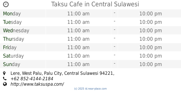
Jalan HOS Cokroaminoto, 94221, Kota Palu, Sulawesi Tengah, ID Indonesia
contacts phone
:
+62
Latitude:
-0.8951438
, Longitude:
119.8599725
larger map & directions
read more
nearest Cafe
94 m
Bubuk Minuman Palu
Siranindi
Cafe
read more
101 m
Kios SURYA BANJAR
Jalan Teuku Umar No.80, Baru
Cafe
read more
133 m
Bakso Tenis
Siranindi
Cafe
read more
182 m
Palbar Cafe & Co
Siranindi
Cafe
read more
236 m
Manna Bakery
Jalan Gajah Mada, Siranindi
Cafe
read more
294 m
D'Warunk
Jalan Kyai Haji Wahid Hasyim No.52, Baru
Cafe
read more
296 m
Warkop Harapan Indah
Jalan Danau Lindu No. 2, Siranindi, Palu Barat, Siranindi
Cafe
read more
320 m
Cafe Intel
Jl. Wahid Hasyim, Baru
Cafe
read more
437 m
Es Teler Bandung
Jalan Imam Bonjol, Baru
Cafe
read more
525 m
Kedai "Bean The Kitty"
Jalan Rajamoili No.33, Besusu Barat
Cafe
read more
616 m
YR Mart & Travel
Kamonji
Cafe
read more
632 m
Taksu Cafe
Lere
Cafe
read more
647 m
WARUNG MAKAN TOLEDO
Jalan Sis Aljufri, Siranindi
Cafe
read more
658 m
ROM Food And Dessert
Jalan Sungai Wera, Ujuna
Cafe
read more
745 m
Kedai The Kamondji
Kamonji
Cafe
read more
758 m
Cuci Motor Salju Lampu 10
Ujuna
Cafe
read more
888 m
Tree By Three
Jalan Sultan Hasanuddin No.65, Lolu Utara
Cafe
read more
890 m
Home industri ROM Food And Dessert
Jalan Sungai Wera, Ujuna
Cafe
read more
911 m
Warkop Celebes
Jalan Haji Hayun, Besusu Barat
Cafe
read more
1.003 km
warkop kurnia
Jalan Pattimura, Lolu Utara
Cafe
read more
1.007 km
Infinity Gaming Net
Jalan Doktor Suharso, Besusu Barat
Cafe
read more
1.008 km
Quick Cafe (Eat Play Fun)
North Lolu
Cafe
read more
1.009 km
Infinity Net
Jalan Doktor Suharso, Besusu Barat
Cafe
read more
1.057 km
Shop Black and White
Jalan Belimbing, Kamonji
Cafe
read more
1.217 km
THE ALLEGIANT Eatery and Beer
Besusu Barat
Cafe
read more
📑
all categories
Accounting
Administrative area level 1
Administrative area level 2
Airport
Amusement park
Aquarium
Art gallery
Atm
Bakery
Bank
Bar
Beauty salon
Bicycle store
Book store
Bowling alley
Bus station
Cafe
Campground
Car dealer
Car rental
Car repair
Car wash
Casino
Cemetery
Church
City hall
Clothing store
Colloquial area
Convenience store
Courthouse
Dentist
Department store
Doctor
Electrician
Electronics store
Embassy
Finance
Fire station
Florist
Food
Funeral home
Furniture store
Gas station
General contractor
Grocery or supermarket
Gym
Hair care
Hardware store
Health
Hindu Temple
Home goods store
Hospital
Insurance agency
Intersection
Jewelry store
Laundry
Lawyer
Library
Liquor store
Local government office
Locality
Locksmith
Lodging
Meal delivery
Meal takeaway
Mosque
Movie rental
Movie theater
Moving company
Museum
Natural feature
Neighborhood
Night club
Painter
Park
Parking
Pet store
Pharmacy
Physiotherapist
Place of worship
Plumber
Point of interest
Police
Political
Post office
Premise
Real estate agency
Restaurant
Roofing contractor
Route
Rv park, camping
School
Shoe store
Shopping mall
Spa
Stadium
Storage
Store
Subpremise
Supermarket
Synagogue
Taxi stand
Train station
Transit station
Travel agency
University
Veterinary care
Zoo
administrative area level 3
administrative area level 4
administrative area level 5
sublocality level 1
↑