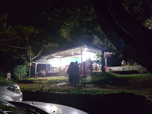
Cafe nearby Warung Kang Nano, Kondang - Ciherang
Indonesia
Cafe nearby Warung Kang Nano, Kondang - Ciherang
Warung Kang Nano, Kondang - Ciherang
Pabuaran Indonezja
contacts phone
:
+62
Latitude:
-6.549646
, Longitude:
106.9419842
read more
nearest Cafe
1.254 km
Salon SpA Adinda
Unnamed Road, Pabuaran
Cafe
read more
1.256 km
Cafee Anggi Kusnadi
Pabuaran
Cafe
read more
1.491 km
BATU Kali Repleksi
Pabuaran
Cafe
read more
2.082 km
Hafid Fadilah
Jl. Tajur Leuwi Bilik Rt. 01/06, Tajur
Cafe
read more
2.307 km
Toko Jumadi Katasasmita
Pabuaran
Cafe
read more
2.407 km
Cafe Aiun
Pabuaran
Cafe
read more
2.408 km
Kafe Angin Marumbus
Pabuaran
Cafe
read more
2.429 km
Warung Nasi Rindanis
Jalan Tajurrayaleuwi No.184, Tajur
Cafe
read more
2.67 km
Kafe Indrah
Jalan Raya Cioray, Leuwikaret
Cafe
read more
3.587 km
Warung Sederhana
Jl. Tajur Leuwi Bilik, Tajur
Cafe
read more
3.595 km
Toko Bajak Laut
Leuwikaret
Cafe
read more
3.607 km
Warung Sate Madura
Jalan Ke Bojong Sari, Leuwikaret
Cafe
read more
3.638 km
Toko Anies Matta
Jalan Ke Bojong Sari, Leuwikaret
Cafe
read more
3.793 km
toko zaki
Cibadak
Cafe
read more
3.89 km
Warung Pak Ramlan
Leuwikaret
Cafe
read more
4.327 km
Warung Bakso Lis Dahlia
Ligarmukti
Cafe
read more
4.642 km
Dunia Spa Jun
Central Karang
Cafe
read more
5.082 km
Wawas Argo
Jalan Bojong Sari, Cibodas
Cafe
read more
5.258 km
Ameera Cafe
Jalan Desa, Karang Tengah
Cafe
read more
5.461 km
Cafe Bukit Batu Kemun
Central Karang
Cafe
read more
5.554 km
Bakso AA
Unnamed Road, Hambalang
Cafe
read more
5.563 km
Blue.net
Jalan Haji Abu Bakar, Hambalang
Cafe
read more
5.572 km
Warkop Reborn Pak Ikhsan
Jalan Haji Abu Bakar No.9
Cafe
read more
5.572 km
Warkop Reborn Pak Ikhsan
Jalan Haji Abu Bakar No.9, Tajur
Cafe
read more
6.726 km
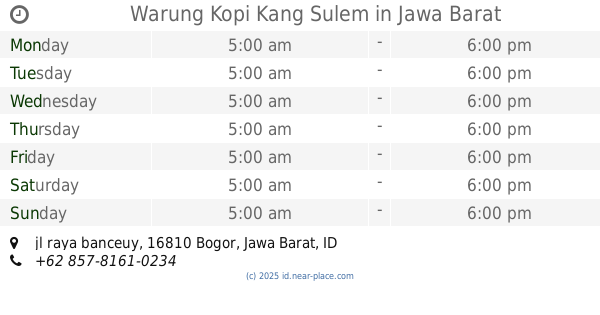
Warung Kopi Kang Sulem
jl raya banceuy, Bojong Koneng
Cafe
read more
📑
all categories
Accounting
Administrative area level 1
Administrative area level 2
Airport
Amusement park
Aquarium
Art gallery
Atm
Bakery
Bank
Bar
Beauty salon
Bicycle store
Book store
Bowling alley
Bus station
Cafe
Campground
Car dealer
Car rental
Car repair
Car wash
Casino
Cemetery
Church
City hall
Clothing store
Colloquial area
Convenience store
Courthouse
Dentist
Department store
Doctor
Electrician
Electronics store
Embassy
Finance
Fire station
Florist
Food
Funeral home
Furniture store
Gas station
General contractor
Grocery or supermarket
Gym
Hair care
Hardware store
Health
Hindu Temple
Home goods store
Hospital
Insurance agency
Intersection
Jewelry store
Laundry
Lawyer
Library
Liquor store
Local government office
Locality
Locksmith
Lodging
Meal delivery
Meal takeaway
Mosque
Movie rental
Movie theater
Moving company
Museum
Natural feature
Neighborhood
Night club
Painter
Park
Parking
Pet store
Pharmacy
Physiotherapist
Place of worship
Plumber
Point of interest
Police
Political
Post office
Premise
Real estate agency
Restaurant
Roofing contractor
Route
Rv park, camping
School
Shoe store
Shopping mall
Spa
Stadium
Storage
Store
Subpremise
Supermarket
Synagogue
Taxi stand
Train station
Transit station
Travel agency
University
Veterinary care
Zoo
administrative area level 3
administrative area level 4
administrative area level 5
sublocality level 1
↑