Cafe nearby Waroeng Kopi Taman Dewa
Indonesia
Cafe nearby Waroeng Kopi Taman Dewa
Waroeng Kopi Taman Dewa
Jalan El Tari No.102, Oebobo Indonesia
contacts phone
:
+62
Latitude:
-10.1715819
, Longitude:
123.605446
read more
nearest Cafe
16 m
GEBBY FLOWER & CAFE
Jalan El Tari, Oebobo
Cafe
read more
18 m
GEBBY FLORA & CAFE
Oebobo
Cafe
read more
240 m
Afra Cofee
Oebobo
Cafe
read more
314 m
Warung Kelapa Muda Polmil
Belakang Gedung DPRD NTT,, Jalan Polisi Militer, Oebobo
Cafe
read more
381 m
Depot Baja Laut
Jalan El Tari, Oebobo
Cafe
read more
442 m
WARKOP HSC
Oebobo
Cafe
read more
473 m
Warung Masbro
Jalan W.J. Lalamentik, Fatululi
Cafe
read more
505 m
Es BUAH Es TELLER Es CAMPUR mas NURRIL
Oebobo
Cafe
read more
520 m
Titon Bozz
Jalan W.J. Lalamentik No.66, Fatululi
Cafe
read more
534 m
Brotus Fried Chicken (BFC)
Fatululi
Cafe
read more
535 m
Kopi Kupangkoe
Oebobo
Cafe
read more
643 m
Rattan Cafe
Jalan Frans Seda, Fatululi
Cafe
read more
648 m
Pantai Kelapa Lima
On the rock hotel, Oebobo
Cafe
read more
648 m
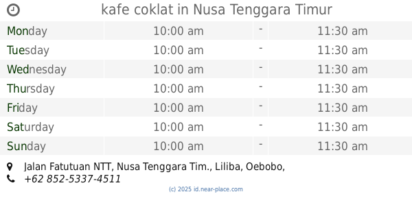
kafe coklat
Jalan Fatutuan NTT, Nusa Tenggara Tim., Liliba
Cafe
read more
675 m
Waroeng Ragil
Naikoten I
Cafe
read more
685 m
TEMPAT MAKAN
Jalan Herewilla No.52, Naikoten II
Cafe
read more
818 m
yakusa net
Jalan Bajawa, Oebufu
Cafe
read more
831 m
BurjoNow33
Jalan Bhakti Besi, Oebobo
Cafe
read more
839 m
Istana Juice
Fatululi
Cafe
read more
888 m
Depot Makan-Kedai Kopi KLA & Batagor BDG Kang Dede
Fatululi
Cafe
read more
888 m
Warung Kopi Ungu & Rumah Es Krim
jln.bakti warga,oebobo, Fatululi
Cafe
read more
965 m
Bubur Ayam Mama Jo
Jalan Palapa, Oebobo
Cafe
read more
975 m
Vapethrough Vape & Caffe
Oebufu
Cafe
read more
994 m
Coffee Gerobak Kupang
Oebobo
Cafe
read more
1.088 km
B&W BARBERSHOP
Jalan Bajawa No.30, Oebufu
Cafe
read more
📑
all categories
Accounting
Administrative area level 1
Administrative area level 2
Airport
Amusement park
Aquarium
Art gallery
Atm
Bakery
Bank
Bar
Beauty salon
Bicycle store
Book store
Bowling alley
Bus station
Cafe
Campground
Car dealer
Car rental
Car repair
Car wash
Casino
Cemetery
Church
City hall
Clothing store
Colloquial area
Convenience store
Courthouse
Dentist
Department store
Doctor
Electrician
Electronics store
Embassy
Finance
Fire station
Florist
Food
Funeral home
Furniture store
Gas station
General contractor
Grocery or supermarket
Gym
Hair care
Hardware store
Health
Hindu Temple
Home goods store
Hospital
Insurance agency
Intersection
Jewelry store
Laundry
Lawyer
Library
Liquor store
Local government office
Locality
Locksmith
Lodging
Meal delivery
Meal takeaway
Mosque
Movie rental
Movie theater
Moving company
Museum
Natural feature
Neighborhood
Night club
Painter
Park
Parking
Pet store
Pharmacy
Physiotherapist
Place of worship
Plumber
Point of interest
Police
Political
Post office
Premise
Real estate agency
Restaurant
Roofing contractor
Route
Rv park, camping
School
Shoe store
Shopping mall
Spa
Stadium
Storage
Store
Subpremise
Supermarket
Synagogue
Taxi stand
Train station
Transit station
Travel agency
University
Veterinary care
Zoo
administrative area level 3
administrative area level 4
administrative area level 5
sublocality level 1
↑