Cafe nearby The C cafe
Indonesia
Cafe nearby The C cafe
The C cafe
Jalan Raya Cibadak - Sukabumi, 43351, Sukabumi, Jawa Barat, ID Indonezja
contacts phone
:
+62 896-8148-8711
Latitude:
-6.8943164
, Longitude:
106.7900028
larger map & directions
read more
nearest Cafe
11 m
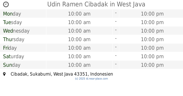
Udin Ramen Cibadak
Cibadak
Cafe
read more
315 m
Istana Juice
Cibadak
Cafe
read more
437 m
ES SARI TEBU ,AYAH
Jalan Sekarwangi, Cibadak
Cafe
read more
451 m
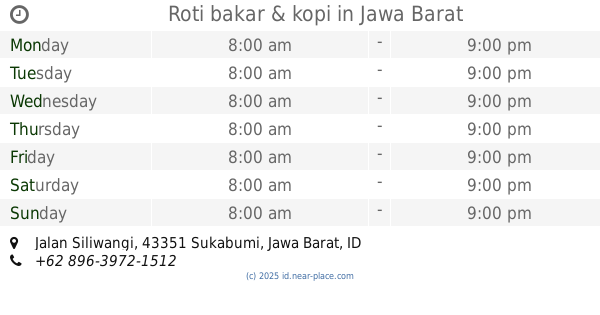
Roti bakar & kopi
Jalan Siliwangi, Cibadak
Cafe
read more
490 m
WAROENG MASGUN
Puskesmas, Batununggal
Cafe
read more
540 m
Kedai Surabi
Cibadak
Cafe
read more
691 m
WAROENG OMA
Cibadak
Cafe
read more
691 m
WAROENG OMA
Cafe
read more
767 m
Xultun Coffee And More
Jalan Perintis Kemerdekaan No.19, Cibadak
Cafe
read more
769 m
CORE Internet & Game Center
Jalan Perintis Kemerdekaan No.50, Cibadak
Cafe
read more
813 m
Warung Soto Mang Bedor
Kp Babakan Panjang Rw 014, Cibadak
Cafe
read more
833 m
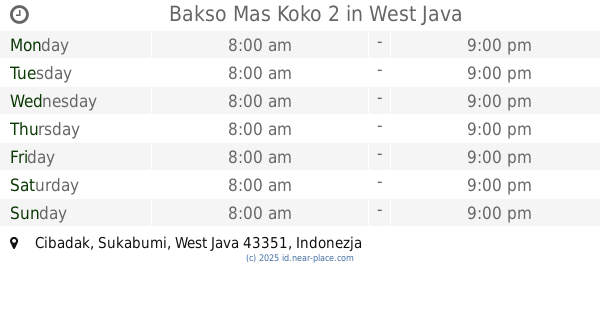
Bakso Mas Koko 2
Cibadak
Cafe
read more
906 m
Mie Jakarta M2M
Jalan Perintis Kemerdekaan, Cibadak
Cafe
read more
909 m
Roti Bakar Ogoed
No.31, Jalan Suryakencana, Cibadak
Cafe
read more
919 m
Roti Bakar Bandung Ogoed
Jalan Raya Sukaraja - Sukabumi, Cibadak
Cafe
read more
1.057 km
Warung Santai Sedia Masakan
jln. alternatif cibadak sukabumi. bungur sarang., Balekambang
Cafe
read more
1.082 km
Agnes Kitchen
Situsaeur
Cafe
read more
1.1 km
Seventeenplus
Jalan Perintis Kemerdekaan No.70, Cibadak
Cafe
read more
1.206 km
NAYOR VAPESTORE
Jalan Raya Cibadak, Cibadak
Cafe
read more
1.24 km
Counter Hana
Jalan Suryakencana, Cibadak
Cafe
read more
1.473 km
Cafe Bunda Ratu
Jalan Raya Nagrak
Cafe
read more
1.479 km
Kopi Padepokan
Balekambang
Cafe
read more
1.707 km
Nasgor AY
Jalan Raya Nagrak, Cisarua
Cafe
read more
1.755 km
Es Kelapa Jelegong
Balekambang
Cafe
read more
2.024 km
Warkop BBT
Warnajati
Cafe
read more
📑
all categories
Accounting
Administrative area level 1
Administrative area level 2
Airport
Amusement park
Aquarium
Art gallery
Atm
Bakery
Bank
Bar
Beauty salon
Bicycle store
Book store
Bowling alley
Bus station
Cafe
Campground
Car dealer
Car rental
Car repair
Car wash
Casino
Cemetery
Church
City hall
Clothing store
Colloquial area
Convenience store
Courthouse
Dentist
Department store
Doctor
Electrician
Electronics store
Embassy
Finance
Fire station
Florist
Food
Funeral home
Furniture store
Gas station
General contractor
Grocery or supermarket
Gym
Hair care
Hardware store
Health
Hindu Temple
Home goods store
Hospital
Insurance agency
Intersection
Jewelry store
Laundry
Lawyer
Library
Liquor store
Local government office
Locality
Locksmith
Lodging
Meal delivery
Meal takeaway
Mosque
Movie rental
Movie theater
Moving company
Museum
Natural feature
Neighborhood
Night club
Painter
Park
Parking
Pet store
Pharmacy
Physiotherapist
Place of worship
Plumber
Point of interest
Police
Political
Post office
Premise
Real estate agency
Restaurant
Roofing contractor
Route
Rv park, camping
School
Shoe store
Shopping mall
Spa
Stadium
Storage
Store
Subpremise
Supermarket
Synagogue
Taxi stand
Train station
Transit station
Travel agency
University
Veterinary care
Zoo
administrative area level 3
administrative area level 4
administrative area level 5
sublocality level 1
↑