Cafe nearby SOSIS BAKAR DA'WAH
Indonesia
Cafe nearby SOSIS BAKAR DA'WAH
SOSIS BAKAR DA'WAH
Mustika Jaya Indonezja
contacts phone
:
+62
Latitude:
-6.2963304
, Longitude:
107.0385859
read more
nearest Cafe
161 m
Warung kopi pojok
Mustika Jaya
Cafe
read more
406 m
Njero Cangkir HSGF
Mustika Jaya
Cafe
read more
414 m
Kopaltine Khazio (Es Kepal Ovaltine)
Mustika Jaya
Cafe
read more
500 m
Cuci Steam Motor &Mobil (ADUHAI MOTOR)
Jalan Gondang No.13-6, Lambangsari
Cafe
read more
579 m
De CakesNCookies
Garden Terrace Blok EA 11 no. 3. Sel., Tambun
Cafe
read more
646 m
Kedai BILOR MAMAH AZKA 🍟
Lambangsari
Cafe
read more
691 m
Sekretariat GLECI
Jalan Kampung Tenggilis, Lambangsari
Cafe
read more
708 m
Warung Bu Bidan
Kampung ciketing, Jalan Kuris RT.02/RW.20, Mustika Jaya
Cafe
read more
714 m
Cafe Kolam
Gang Cupang, Mustika Jaya
Cafe
read more
715 m
Warung Ka Rose
Jl Kp Pekopen Kulon No.49, Lambangjaya
Cafe
read more
727 m
Warung Pa'de Uwes
Mustika Jaya
Cafe
read more
834 m
Waroeng Amar Kusumo
Jalan Kampung Tenggilis No.47, Mustika Jaya
Cafe
read more
840 m
Seblak Bunda Ratu
Jl. Perum Kodam Raya Blok D10 No.2, Mustika Jaya
Cafe
read more
850 m
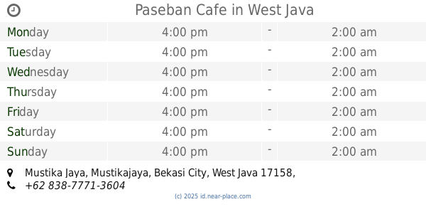
Paseban Cafe
Mustika Jaya
Cafe
read more
869 m
Kedai Es
Jalan Raya Mustika Jaya No.52, Mustika Jaya
Cafe
read more
907 m
Kopdar
Jalan Warung Doyong No.3, Tambun
Cafe
read more
932 m
Risoles Montox
Jalan Raya Mustika Jaya No.103, Mustika Jaya
Cafe
read more
934 m
Cappucino Cincau
Jalan Raya Mustika Jaya, Mustika Jaya
Cafe
read more
935 m
Kedai aLVi
Jalan Raya Mustika Jaya, Mustika Jaya
Cafe
read more
937 m
Warung Asoy Geboy
Jalan Perum Kodam Mustika Jaya, Mustika Jaya
Cafe
read more
961 m
SOPEL NENEK
Lambangsari
Cafe
read more
971 m
Pangkalan OKC
Jalan Perum Kodam Raya Blok B1 No.1, Mustika Jaya
Cafe
read more
1.012 km
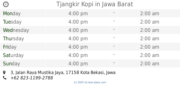
Tjangkir Kopi
Jalan Raya Mustika Jaya No.3, Mustika Jaya
Cafe
read more
1.069 km
CIAWI Juice
Mustika Jaya
Cafe
read more
1.083 km
Es Kelapa Muda Ciawi 1
Mustika Jaya
Cafe
read more
📑
all categories
Accounting
Administrative area level 1
Administrative area level 2
Airport
Amusement park
Aquarium
Art gallery
Atm
Bakery
Bank
Bar
Beauty salon
Bicycle store
Book store
Bowling alley
Bus station
Cafe
Campground
Car dealer
Car rental
Car repair
Car wash
Casino
Cemetery
Church
City hall
Clothing store
Colloquial area
Convenience store
Courthouse
Dentist
Department store
Doctor
Electrician
Electronics store
Embassy
Finance
Fire station
Florist
Food
Funeral home
Furniture store
Gas station
General contractor
Grocery or supermarket
Gym
Hair care
Hardware store
Health
Hindu Temple
Home goods store
Hospital
Insurance agency
Intersection
Jewelry store
Laundry
Lawyer
Library
Liquor store
Local government office
Locality
Locksmith
Lodging
Meal delivery
Meal takeaway
Mosque
Movie rental
Movie theater
Moving company
Museum
Natural feature
Neighborhood
Night club
Painter
Park
Parking
Pet store
Pharmacy
Physiotherapist
Place of worship
Plumber
Point of interest
Police
Political
Post office
Premise
Real estate agency
Restaurant
Roofing contractor
Route
Rv park, camping
School
Shoe store
Shopping mall
Spa
Stadium
Storage
Store
Subpremise
Supermarket
Synagogue
Taxi stand
Train station
Transit station
Travel agency
University
Veterinary care
Zoo
administrative area level 3
administrative area level 4
administrative area level 5
sublocality level 1
↑